File:Roraima ASTER 15 avril 2008.jpg
Jump to navigation
Jump to search
No higher resolution available.
Roraima_ASTER_15_avril_2008.jpg (472 × 426 pixels, file size: 27 KB, MIME type: image/jpeg)
Captions
Captions
Add a one-line explanation of what this file represents
Summary[edit]
| Camera location | | View this and other nearby images on: OpenStreetMap |
|---|
| Description |
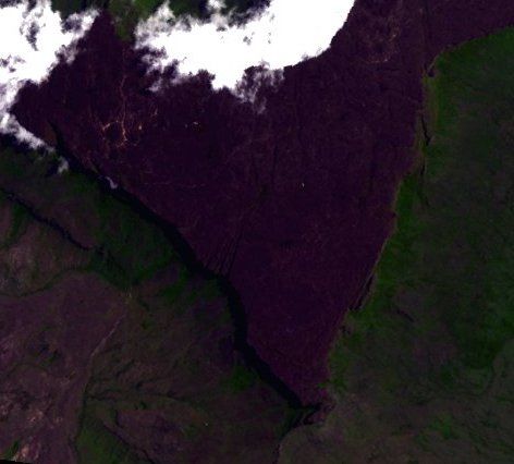
Français : Image satellite du massif du mont Roraima, un tepuy ayant pour caractéristique d'être situé au tripoint du Brésil, du Venezuela et du Guyana. Les récits de la première ascension du mont Roraima à l'époque victorienne ont inspiré Arthur Conan Doyle pour l'écriture du Monde perdu en 1912.
Deutsch: Fernerkundung von Roraima-Tepui.
English: Satellite image in French language of Mount Roraima.
Español: Imagen satelital del Roraima.
Italiano: Immagini satellitari del Roraima.
日本語: ロライマ山の衛星画像.
Português: Imagem de satélite do Monte Roraima. |
||
| Date | (UTC) | ||
| Source |
Création personnelle ;
|
||
| Author | © Bourrichon (talk) - fr:Bourrichon | ||
| Permission (Reusing this file) |
|
| This file is in the public domain in the United States because it was solely created by NASA. NASA copyright policy states that "NASA material is not protected by copyright unless noted". (See Template:PD-USGov, NASA copyright policy page or JPL Image Use Policy.) | ||
 |
Warnings:
|
Licensing[edit]
I, the copyright holder of this work, hereby publish it under the following licenses:

|
Permission is granted to copy, distribute and/or modify this document under the terms of the GNU Free Documentation License, Version 1.2 or any later version published by the Free Software Foundation; with no Invariant Sections, no Front-Cover Texts, and no Back-Cover Texts. A copy of the license is included in the section entitled GNU Free Documentation License. |
This file is licensed under the Creative Commons Attribution-Share Alike 3.0 Unported, 2.5 Generic, 2.0 Generic and 1.0 Generic license.
- You are free:
- to share – to copy, distribute and transmit the work
- to remix – to adapt the work
- Under the following conditions:
- attribution – You must give appropriate credit, provide a link to the license, and indicate if changes were made. You may do so in any reasonable manner, but not in any way that suggests the licensor endorses you or your use.
- share alike – If you remix, transform, or build upon the material, you must distribute your contributions under the same or compatible license as the original.
You may select the license of your choice.
File history
Click on a date/time to view the file as it appeared at that time.
| Date/Time | Thumbnail | Dimensions | User | Comment | |
|---|---|---|---|---|---|
| current | 22:46, 26 April 2012 | | 472 × 426 (27 KB) | Bourrichon (talk | contribs) | == {{int:filedesc}} == {{Location|5|08|28|N|60|45|50|W|scale:500000}} {{Information |Description= {{fr|Image satellite du massif du mont Roraima, un tepuy ayant pour caractéristique d'être situé au [[:fr:tripoint|t... |
You cannot overwrite this file.
File usage on Commons
There are no pages that use this file.
File usage on other wikis
The following other wikis use this file:
- Usage on fr.wikipedia.org