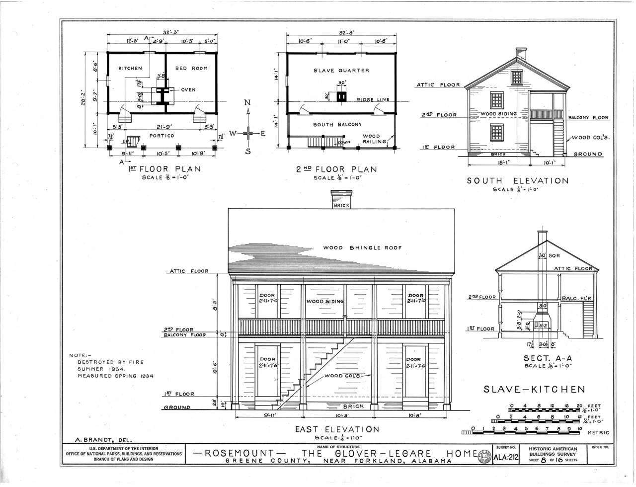
File:Rosemount, County Road 19, Forkland, Greene County, AL HABS ALA,32-FORK.V,1- (sheet 8 of 16).tif
Jump to navigation
Jump to search

Size of this JPG preview of this TIF file: 783 × 600 pixels. Other resolutions: 314 × 240 pixels | 627 × 480 pixels | 1,003 × 768 pixels | 1,280 × 980 pixels | 2,560 × 1,960 pixels | 9,360 × 7,168 pixels.
Original file (9,360 × 7,168 pixels, file size: 630 KB, MIME type: image/tiff)
Captions
Captions
Add a one-line explanation of what this file represents
Summary[edit]
| HABS ALA,32-FORK.V,1- (sheet 8 of 16) - Rosemount, County Road 19, Forkland, Greene County, AL | ||||
|---|---|---|---|---|
| Photographer |
Related names:
|
|||
| Title |
HABS ALA,32-FORK.V,1- (sheet 8 of 16) - Rosemount, County Road 19, Forkland, Greene County, AL |
|||
| Depicted place | Alabama; Greene County; Forkland | |||
| Date | Documentation compiled after 1933 | |||
| Medium | 19 x 24 in. (B size) | |||
| Current location |
Library of Congress Prints and Photographs Division Washington, D.C. 20540 USA http://hdl.loc.gov/loc.pnp/pp.print |
|||
| Accession number |
HABS ALA,32-FORK.V,1- (sheet 8 of 16) |
|||
| Credit line |
|
|||
| Notes |
|
|||
| References |
|
|||
| Source | https://www.loc.gov/pictures/item/al0201.sheet.00008a | |||
| Permission (Reusing this file) |
|
|||
| Other versions |
.png) .png) .png) .png) .png) .png) .png) .png) |
|||

| Camera location | | View this and other nearby images on: OpenStreetMap |
|---|
File history
Click on a date/time to view the file as it appeared at that time.
| Date/Time | Thumbnail | Dimensions | User | Comment | |
|---|---|---|---|---|---|
| current | 01:18, 28 June 2014 |  | 9,360 × 7,168 (630 KB) | Fæ (talk | contribs) | GWToolset: Creating mediafile for Fæ. HABS batch upload restart 26 June 2014 (p21:101)x |
You cannot overwrite this file.
File usage on Commons
The following 2 pages use this file: