File:Sanborn Seattle 1893 map 51a - transformed.jpg

Original file (1,371 × 1,743 pixels, file size: 329 KB, MIME type: image/jpeg)
Captions
Captions
|
This is an image of a place or building that is listed on the National Register of Historic Places in the United States of America. Its reference number is 70000644. |
Summary[edit]
| Description |
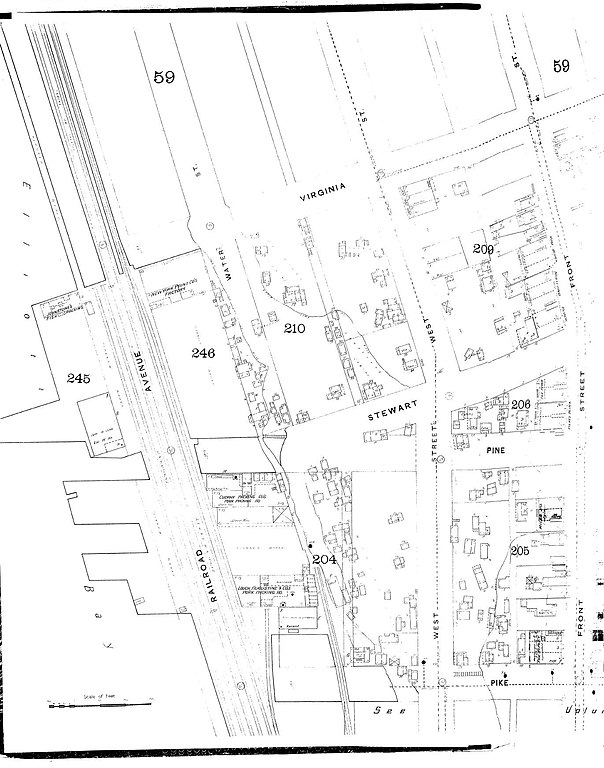
1893 map of part of Seattle, Washington. The map extends from the waterfront northeast to Front Street (now First Avenue) and from Pike Street northwest roughly to Virginia Street. Most of what is visible here now falls within the city-designated Pike Place Market Historical District. This considerably predates the Market, which began in 1907 (and Pike Place itself, built around that same era). West Street is now Western Avenue. Railroad Avenue is now Alaskan Way. Water Street is now Elliott Avenue, but I believe this portion of it no longer exists. This is not a great scan. The portion at right is clearly distorted: these streets run straight (except that Front Street jogs at Stewart). |
| Date | |
| Source | Map 51a, Seattle, Washington 1893 Volume 2, Sanborn-Perris Map Co. Limited, New York (1893), reproduced on the "Digital Sanborn Maps 1867-1970" online (subscription) database |
| Author | Sanborn-Perris Map Company |
| Permission (Reusing this file) |
PD-US |
| Other versions | Image:Sanborn Seattle 1893 map 51a.jpg is raw. Image:Sanborn Seattle 1893 map 51a - transformed.jpg is transformed with GIMP to try to clean up the distortion. Needless to say, the correction isn't perfect. |
| Object location | | View this and other nearby images on: OpenStreetMap |
|---|
Licensing[edit]
This media file is in the public domain in the United States. This applies to U.S. works where the copyright has expired, often because its first publication occurred prior to January 1, 1929, and if not then due to lack of notice or renewal. See this page for further explanation.
|
 | |
 |
This image might not be in the public domain outside of the United States; this especially applies in the countries and areas that do not apply the rule of the shorter term for US works, such as Canada, Mainland China (not Hong Kong or Macao), Germany, Mexico, and Switzerland. The creator and year of publication are essential information and must be provided. See Wikipedia:Public domain and Wikipedia:Copyrights for more details.
|
File history
Click on a date/time to view the file as it appeared at that time.
| Date/Time | Thumbnail | Dimensions | User | Comment | |
|---|---|---|---|---|---|
| current | 20:31, 4 October 2008 | | 1,371 × 1,743 (329 KB) | Jmabel (talk | contribs) | == Summary == {{Information |Description=1893 map of part of Seattle, Washington. The map extends from the waterfront northeast to Front Street (now First Avenue) and from Pike Street northwest roughly to Virginia Street. Most of what is visible here now |
You cannot overwrite this file.
File usage on Commons
There are no pages that use this file.
File usage on other wikis
The following other wikis use this file:
- Usage on en.wikipedia.org