File:Satellitenfotos des japanischen Katastrophengebietes nach dem Tsunami 2011.jpg
Jump to navigation
Jump to search

Size of this preview: 800 × 450 pixels. Other resolutions: 320 × 180 pixels | 640 × 360 pixels | 1,024 × 576 pixels | 1,418 × 798 pixels.
Original file (1,418 × 798 pixels, file size: 1.08 MB, MIME type: image/jpeg)
Captions
Captions
Fukushima nuclear accident
Summary[edit]
| Description |
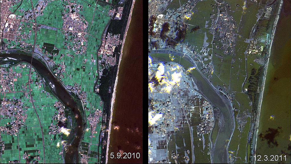
Deutsch: Das Bild zeigt Satellitenaufnahmen desselben Küstenabschnitts in Japan am 5 September 2010 und am 12 March 2011 in dem zerstörte Siedlungen durch den Tsunami des Tōhoku-Erdbeben erkennbar sind.
English: The picture show the same region from japanese coast twice. The first shot was created on 5 September 2010, the second on 12 March 2011. You can see destroyed settlements, caused by the tsunami from the Tōhoku earthquake. |
| Date | 5 September 2010 and 12 March 2011 |
| Source | http://www.dlr.de/dlr/desktopdefault.aspx/tabid-10460/685_read-759/year-all/ |
| Author |
Deutsch: Deutsches Zentrum für Luft- und Raumfahrt, Rapid Eye
English: German Aerospace Center, Rapid Eye |
Licensing[edit]
| This media has been released under a free license by the Deutsches Zentrum für Luft- und Raumfahrt (DLR). Their website states: "Where expressly stated, DLR images and videos are covered by a Creative Commons Attribution 3.0 Germany (CC BY 3.0) licence. This licence grants permission to reproduce or distribute the work, to make the work and/or its contents publically available, to alter or edit the work and/or its contents and to make commercial use of the work, provided that you explicitly mention DLR as its source in a clearly legible format. Examples: 'Photo: DLR, CC-BY 3.0', 'Images: DLR, CC-BY 3.0', 'Video: DLR, CC-BY 3.0'." To the uploader: You must provide a link (URL) to the original file and the authorship information if available. |
This file is licensed under the Creative Commons Attribution 3.0 Germany license.
Attribution: DLR, CC-BY 3.0
- You are free:
- to share – to copy, distribute and transmit the work
- to remix – to adapt the work
- Under the following conditions:
- attribution – You must give appropriate credit, provide a link to the license, and indicate if changes were made. You may do so in any reasonable manner, but not in any way that suggests the licensor endorses you or your use.

File history
Click on a date/time to view the file as it appeared at that time.
| Date/Time | Thumbnail | Dimensions | User | Comment | |
|---|---|---|---|---|---|
| current | 20:22, 28 April 2012 | | 1,418 × 798 (1.08 MB) | Jotpe (talk | contribs) |
You cannot overwrite this file.
File usage on Commons
The following 2 pages use this file:
File usage on other wikis
The following other wikis use this file:
- Usage on de.wikipedia.org