File:Schluchsee-Ursee.jpg
Jump to navigation
Jump to search
Size of this preview: 800 × 564 pixels. Other resolutions: 320 × 225 pixels | 640 × 451 pixels | 982 × 692 pixels.
Original file (982 × 692 pixels, file size: 89 KB, MIME type: image/jpeg)
Captions
Captions
Add a one-line explanation of what this file represents
Summary
[edit]
| Description |
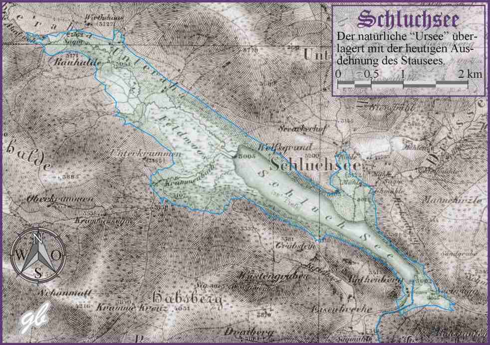
Deutsch: Überlagerung einer Karte des natürlich Schluchsees, wie er bis Anfang der 30-er Jahre des 20. Jahrhunderts als sogenannter Ursee bestand, mit der neutigen Ausdehung des Stausees bei Vollstau |
| Date | |
| Source | Kartengrundlage: Topographische Karte über das GROSSHERZOGTHUM BADEN nach der allgemeinen Landesvermeßung des Großherzoglichen militairisch topographischen Bureaus aus dem Jahre 1847. |
| Author | G. Boll, Waldshut |
Licensing
[edit]

|
Permission is granted to copy, distribute and/or modify this document under the terms of the GNU Free Documentation License, Version 1.2 or any later version published by the Free Software Foundation; with no Invariant Sections, no Front-Cover Texts, and no Back-Cover Texts. A copy of the license is included in the section entitled GNU Free Documentation License. |
| This file is licensed under the Creative Commons Attribution-Share Alike 3.0 Unported license. | ||
| ||
| This licensing tag was added to this file as part of the GFDL licensing update. |
Original upload log
[edit]
The original description page was here. All following user names refer to de.wikipedia.
- 2006-04-05 22:06 G-Boll 982×692× (91199 bytes) Überlagerung einer Karte des natürlich Schluchsees, wie er bis Anfang der 30-er Jahre des 20. Jahrhunderts als sogenannter ''Ursee'' bestand, mit der neutigen Ausdehung des Stausees bei Vollstau.<br> Kartengrundlage: ''Topographische Karte über das GRO
- 2006-04-05 22:01 G-Boll 982×691× (91011 bytes) Überlagerung einer Karte des natürlich Schluchsees, wie er bis Anfang der 30-er Jahre des 20. Jahrhunderts als sogenannter ''Ursee'' bestand, mit der neutigen Ausdehung des Stausees bei Vollstau.<br> Kartengrundlage: ''Topographische Karte über das GRO
File history
Click on a date/time to view the file as it appeared at that time.
| Date/Time | Thumbnail | Dimensions | User | Comment | |
|---|---|---|---|---|---|
| current | 17:54, 7 September 2009 | | 982 × 692 (89 KB) | File Upload Bot (Magnus Manske) (talk | contribs) | {{BotMoveToCommons|de.wikipedia|year={{subst:CURRENTYEAR}}|month={{subst:CURRENTMONTHNAME}}|day={{subst:CURRENTDAY}}}} {{Information |Description={{de|Überlagerung einer Karte des natürlich Schluchsees, wie er bis Anfang der 30-er Jahre des 20. Jahrhun |
You cannot overwrite this file.
File usage on Commons
The following page uses this file:
File usage on other wikis
The following other wikis use this file:
- Usage on als.wikipedia.org
- Usage on de.wikipedia.org
- Usage on de.wikivoyage.org
- Usage on en.wikipedia.org
- Usage on nl.wikipedia.org
- Usage on pl.wikipedia.org
- Usage on ru.wikipedia.org