File:Sea-of-Okhotsk-Full-Map-Hokkaido-Kuril-Kamchatka-Sakhalin.png
Jump to navigation
Jump to search

Size of this preview: 800 × 547 pixels. Other resolutions: 320 × 219 pixels | 640 × 438 pixels | 1,024 × 700 pixels | 1,280 × 875 pixels | 2,560 × 1,751 pixels | 5,188 × 3,548 pixels.
Original file (5,188 × 3,548 pixels, file size: 14.83 MB, MIME type: image/png)
Captions
Captions
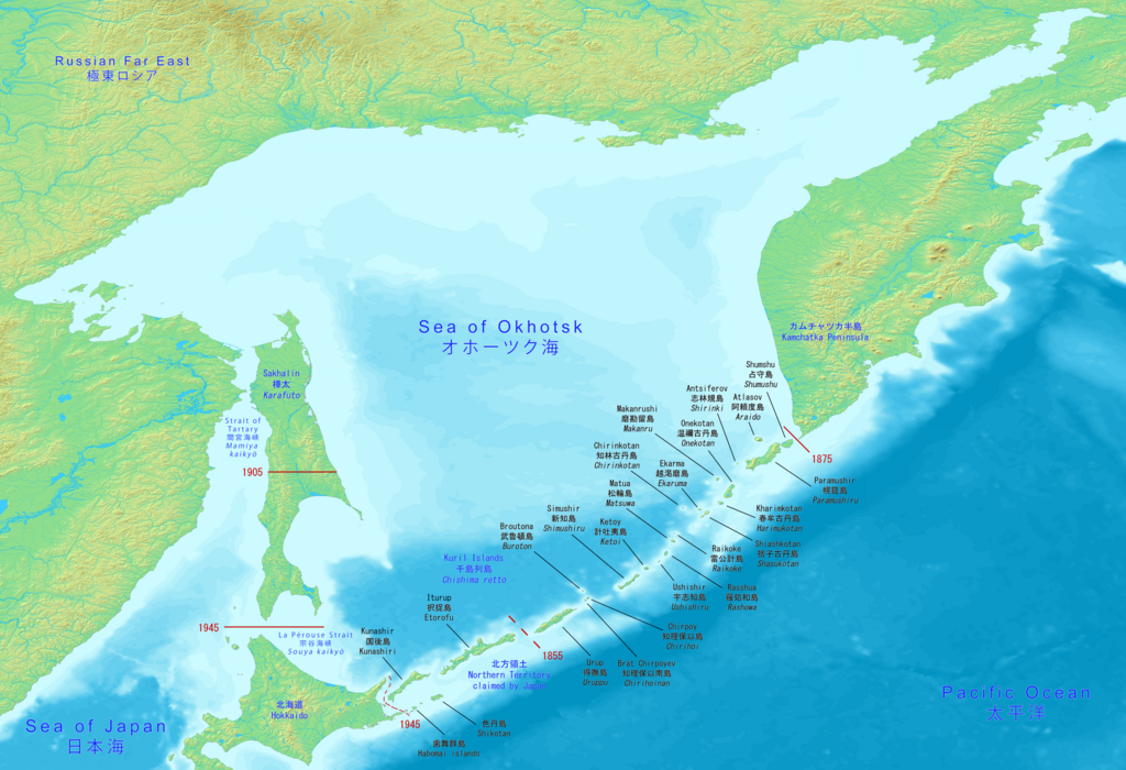
Full map of the Sea of Okhotsk with Hokkaido, Kuril islands, Kamchatka peninsula and Sakhalin.
Summary
[edit]| Description |
English: Big map has the full Sea of Okhotsk with Hokkaido, Kuril islands, Kamchatka peninsula and Sakhalin (Karafuto). It includes the Japanese and Russian names with English.
日本語: 大きな地図には、北海道、千島列島、カムチャッカ半島、サハリン(樺太)を含むオホーツク海全体が表示されます。 日本語とロシア語の名前と英語が含まれています。
Русский: Большая карта имеет полное Охотское море с Хоккайдо, Курильскими островами, полуостровом Камчатка и Сахалином (Карафуто). В него входят японские и русские названия с английскими. |
| Date | |
| Source | Made with DEMIS World Map Server https://www.demis.nl/products/web-map-server/examples |
| Author | DEMIS World Map Server, Artanisen |
| Other versions |
|

Licensing
[edit]
| This file is made available under the Creative Commons CC0 1.0 Universal Public Domain Dedication. | |
| The person who associated a work with this deed has dedicated the work to the public domain by waiving all of their rights to the work worldwide under copyright law, including all related and neighboring rights, to the extent allowed by law. You can copy, modify, distribute and perform the work, even for commercial purposes, all without asking permission.
|
File history
Click on a date/time to view the file as it appeared at that time.
| Date/Time | Thumbnail | Dimensions | User | Comment | |
|---|---|---|---|---|---|
| current | 15:10, 17 June 2020 | | 5,188 × 3,548 (14.83 MB) | Artanisen (talk | contribs) | Corrected Japanese spelling: オホーツク海 |
| 00:37, 17 June 2020 |  | 5,188 × 3,548 (14.83 MB) | Artanisen (talk | contribs) | Fixed letter font of Shumshu. | |
| 16:44, 16 June 2020 |  | 5,188 × 3,548 (14.83 MB) | Artanisen (talk | contribs) | Updated to show the full Sea of Okhotsk with a big detailed map. It includes the Japanese and Russian names with standard English translations. | |
| 21:00, 13 June 2020 |  | 3,280 × 2,144 (2.24 MB) | Artanisen (talk | contribs) | Uploaded a work by DEMIS World Map Server, Artanisen from https://www.demis.nl/products/web-map-server/examples with UploadWizard |
You cannot overwrite this file.
File usage on Commons
The following 3 pages use this file:
File usage on other wikis
The following other wikis use this file:
- Usage on ca.wikipedia.org
- Usage on en.wikipedia.org
- Usage on ky.wikipedia.org
- Usage on sl.wikipedia.org
- Usage on sr.wikipedia.org