File:Serbia ethnic 6 8 century-sr.png
Jump to navigation
Jump to search

Size of this preview: 334 × 600 pixels. Other resolutions: 133 × 240 pixels | 638 × 1,146 pixels.
Original file (638 × 1,146 pixels, file size: 66 KB, MIME type: image/png)
Captions
Captions
Add a one-line explanation of what this file represents
Summary[edit]
| Description |
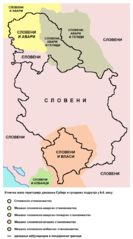
English: Ethnic map of the territory of present-day Serbia and neighbouring areas in the 6th-8th century (according to the historical atlas for schools, published in Belgrade in 1970). Српски / srpski: Етничка мапа територије данашње Србије и околних подручја у 6-8. веку (мапа је урађена према Школском историјском атласу, објављеном у Београду 1970. године). |
| Date | |
| Source | Own work |
| Author | PANONIAN |
Licensing[edit]
I, the copyright holder of this work, hereby publish it under the following license:
| This file is made available under the Creative Commons CC0 1.0 Universal Public Domain Dedication. | |
| The person who associated a work with this deed has dedicated the work to the public domain by waiving all of their rights to the work worldwide under copyright law, including all related and neighboring rights, to the extent allowed by law. You can copy, modify, distribute and perform the work, even for commercial purposes, all without asking permission.
|
References[edit]
Main reference:
- Created according to the historical map from this history atlas: "Školski istorijski atlas, Zavod za izdavanje udžbenika SR Srbije, Beograd, 1970."
Secondary references (with similar maps):
- The Times - Atlas Svjetske Povijesti, Dopunjeno izdanje za Jugoslaviju, Cankarjeva založba, Ljubljana, 1986. - this is Yugoslav (Serbo-Croatian) edition of this original source: The Times Atlas of World History, Times Books Limited, London, 1984. (in Yugoslav version from 1986 there is similar map on page number 298)
- Denis Šehić - Demir Šehić, Istorijski atlas Sveta, Beograd, 2007. (similar map is published on page number 29)
- The former Yugoslavia's diverse peoples: a reference sourcebook By Matjaž Klemenčič, Mitja Žagar: https://books.google.com/books?id=ORSMBFwjAKcC&pg=PA3&lpg=PA5&vq=maps&output=html (a source with similar map published on page number 3)
- Here is an external link with similar map: http://www.camo.ch/illiricum7.htm archive copy at the Wayback Machine
File history
Click on a date/time to view the file as it appeared at that time.
| Date/Time | Thumbnail | Dimensions | User | Comment | |
|---|---|---|---|---|---|
| current | 19:45, 25 February 2014 | | 638 × 1,146 (66 KB) | PANONIAN (talk | contribs) | {{Information |Description ={{en|1=Ethnic map of the territory of present-day Serbia and neighbouring areas in the 6th-8th century (according to the historical atlas for schools, published in Belgrade in 1970).}} |Source ={{own}} |Author... |
You cannot overwrite this file.
File usage on Commons
There are no pages that use this file.
File usage on other wikis
The following other wikis use this file:
- Usage on mk.wikipedia.org
- Usage on sr.wikipedia.org
Categories:
- Historical maps of ethnic groups in Vojvodina
- Historical maps of ethnic groups in Kosovo
- Historical maps of ethnic groups in the Balkans
- Maps of the South Slavs
- Maps of the Gepids
- Maps of Eurasian Avars
- Avar Khaganate
- Maps of ethnic groups in Serbia
- Maps of the history of Serbia in the Early Middle Ages
- Maps of the history of Romania in the Middle Ages
- Serbian-language maps