File:Serra do Suido.svg
Jump to navigation
Jump to search

Size of this PNG preview of this SVG file: 800 × 588 pixels. Other resolutions: 320 × 235 pixels | 640 × 471 pixels | 1,024 × 753 pixels | 1,280 × 941 pixels | 2,560 × 1,882 pixels | 1,258 × 925 pixels.
Original file (SVG file, nominally 1,258 × 925 pixels, file size: 958 KB)
Captions
Captions
Add a one-line explanation of what this file represents
Summary[edit]
| Description |
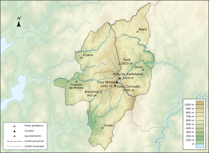
English: topographical map from "Serra do Suído" in Galicia (Spain) with rivers, mountains and main populations
Español: Mapa topográfico de la "Serra do Suído" en Galicia (España) con ríos, cimas y ayuntamientos |
| Date | |
| Source | Own work |
| Author | Edoarado |
Elevación topográfica obtenida a partir de los datos de SRTM, procesados con 3DEM y MapWindow GIS (http://www.mapwindow.org/).
Licensing[edit]
I, the copyright holder of this work, hereby publish it under the following licenses:

|
Permission is granted to copy, distribute and/or modify this document under the terms of the GNU Free Documentation License, Version 1.2 or any later version published by the Free Software Foundation; with no Invariant Sections, no Front-Cover Texts, and no Back-Cover Texts. A copy of the license is included in the section entitled GNU Free Documentation License. |
This file is licensed under the Creative Commons Attribution-Share Alike 3.0 Unported license.
- You are free:
- to share – to copy, distribute and transmit the work
- to remix – to adapt the work
- Under the following conditions:
- attribution – You must give appropriate credit, provide a link to the license, and indicate if changes were made. You may do so in any reasonable manner, but not in any way that suggests the licensor endorses you or your use.
- share alike – If you remix, transform, or build upon the material, you must distribute your contributions under the same or compatible license as the original.
You may select the license of your choice.
File history
Click on a date/time to view the file as it appeared at that time.
| Date/Time | Thumbnail | Dimensions | User | Comment | |
|---|---|---|---|---|---|
| current | 11:05, 19 November 2010 | | 1,258 × 925 (958 KB) | Edoarado (talk | contribs) | {{Information |Description={{en|1=topographical map from "Serra do Suído" in Galicia (Spain) with rivers, mountains and main populations}} {{es|1=Mapa topográfico de la "Serra do Suído" en Galicia (España) con ríos, cimas y ayuntamientos}} |Source={{ |
You cannot overwrite this file.
File usage on Commons
The following page uses this file:
File usage on other wikis
The following other wikis use this file:
- Usage on es.wikipedia.org
- Usage on gl.wikipedia.org
- Usage on mt.wikipedia.org