File:Map 61 - Bosnia - Srebrenica & Zepa, July 1995.jpg
(Redirected from File:Srebrenica massacre map.jpg)

Size of this preview: 458 × 599 pixels. Other resolutions: 183 × 240 pixels | 367 × 480 pixels | 587 × 768 pixels | 782 × 1,024 pixels | 1,679 × 2,197 pixels.
Original file (1,679 × 2,197 pixels, file size: 498 KB, MIME type: image/jpeg)
Captions
Captions
Add a one-line explanation of what this file represents
Summary[edit]
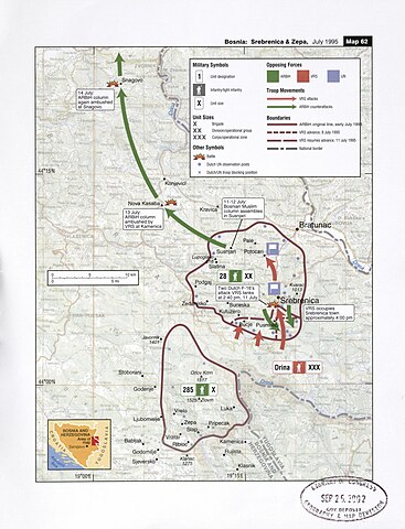
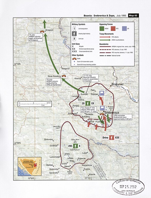
| Description | Map of military operations on July, 1995 against the town of Srebrenica |
| Date | |
| Source | Balkan Battlegrounds: A Military History of the Yugoslav Conflict; Map Case, 2002, Library of Congress (Original Size) |
| Author | Central Intelligence Agency |
| Other versions | Derivative works of this file: Map 61 - Bosnia - Srebrenica & Zepa, July 1995 hu.png |
Licensing[edit]
| This image is a work of a Central Intelligence Agency employee, taken or made as part of that person's official duties. As a Work of the United States Government, this image or media is in the public domain in the United States.
|

|
File history
Click on a date/time to view the file as it appeared at that time.
| Date/Time | Thumbnail | Dimensions | User | Comment | |
|---|---|---|---|---|---|
| current | 01:16, 9 October 2016 | | 1,679 × 2,197 (498 KB) | Ранко Николић (talk | contribs) | https://www.loc.gov/resource/g6841sm.gct00210/?sp=61 |
| 08:40, 26 May 2006 |  | 697 × 896 (213 KB) | Vercingetorix~commonswiki (talk | contribs) | Map of military operations during the Srebrenica massacre, July 1995 From "Balkan Battlegrounds", 2002 {{PD-USGov-CIA}} From: http://en.wikipedia.org/wiki/Image:Srebrenica_massacre_map.jpg |
You cannot overwrite this file.
File usage on Commons
The following 5 pages use this file:
File usage on other wikis
The following other wikis use this file:
- Usage on ar.wikipedia.org
- Usage on azb.wikipedia.org
- Usage on az.wikipedia.org
- Usage on be.wikipedia.org
- Usage on bg.wikipedia.org
- Usage on ca.wikipedia.org
- Usage on cs.wikipedia.org
- Usage on da.wikipedia.org
- Usage on en.wikipedia.org
- Usage on es.wikipedia.org
- Usage on eu.wikipedia.org
- Usage on fa.wikipedia.org
- Usage on fi.wikipedia.org
- Usage on gl.wikipedia.org
- Usage on he.wikipedia.org
- Usage on hr.wikipedia.org
- Usage on hu.wikipedia.org
- Usage on is.wikipedia.org
- Usage on it.wikipedia.org
- Usage on ja.wikipedia.org
- Usage on ka.wikipedia.org
- Usage on ko.wikipedia.org
- Usage on lt.wikipedia.org
- Usage on mk.wikipedia.org
- Usage on ms.wikipedia.org
- Usage on no.wikipedia.org
- Usage on ru.wikipedia.org
- Usage on sh.wikipedia.org
- Usage on sl.wikipedia.org
- Usage on sr.wikipedia.org
- Usage on tr.wikipedia.org
- Usage on tt.wikipedia.org
View more global usage of this file.