File:Svetloyarsk anticlinal structure. Profile cut.png
Jump to navigation
Jump to search

Size of this preview: 800 × 577 pixels. Other resolutions: 320 × 231 pixels | 640 × 461 pixels | 1,024 × 738 pixels | 1,280 × 923 pixels | 2,560 × 1,845 pixels | 3,786 × 2,729 pixels.
Original file (3,786 × 2,729 pixels, file size: 540 KB, MIME type: image/png)
Captions
Captions
Add a one-line explanation of what this file represents
Summary[edit]
| Description |
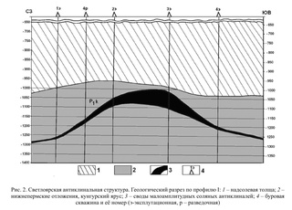
Русский: Светлоярская антиклинальная структура. Геологический разрез по профилю I: 1 — надсолевая толща; 2 — нижнепермские отложения, кунгурский ярус; 3 — своды малоамплитудных соляных антиклиналей; 4 — буровая скважина и её номер (э — эксплутационная, р — разведочная). |
| Date | |
| Source | Внутренняя соляная тектоника в галогенной толще Гремячинского месторождения калийных солей // Известия Саратовского университета. Новая серия. Серия Науки о Земле. — 2011. — № 2. |
| Author | Свидзинский С. А., Фёдоров С. А., Московский Г. А. |
Licensing[edit]
This file is licensed under the Creative Commons Attribution 4.0 International license.
Attribution: https://geo.sgu.ru
- You are free:
- to share – to copy, distribute and transmit the work
- to remix – to adapt the work
- Under the following conditions:
- attribution – You must give appropriate credit, provide a link to the license, and indicate if changes were made. You may do so in any reasonable manner, but not in any way that suggests the licensor endorses you or your use.
File history
Click on a date/time to view the file as it appeared at that time.
| Date/Time | Thumbnail | Dimensions | User | Comment | |
|---|---|---|---|---|---|
| current | 19:43, 4 February 2021 | | 3,786 × 2,729 (540 KB) | Redboston (talk | contribs) | Uploaded a work by Свидзинский С. А., Федоров С. А., Московский Г. А. from [https://cyberleninka.ru/article/n/vnutrennyaya-solyanaya-tektonika-v-galogennoy-tolsche-gremyachinskogo-mestorozhdeniya-kaliynyh-soley Внутренняя соляная тектоника в галогенной толще Гремячинского месторождения калийных солей] // [https://geo.sgu.ru Известия Саратовского университета. Новая серия. Серия Науки о Земле]. — 2011. — [https://geo.sgu.ru/ru/journal/2011/2 № 2]. with UploadWizard |
You cannot overwrite this file.
File usage on Commons
The following page uses this file:
File usage on other wikis
The following other wikis use this file:
- Usage on ru.wikipedia.org