File:Tarawa-old.jpg
Jump to navigation
Jump to search

Size of this preview: 485 × 599 pixels. Other resolutions: 194 × 240 pixels | 389 × 480 pixels | 643 × 794 pixels.
Original file (643 × 794 pixels, file size: 119 KB, MIME type: image/jpeg)
Captions
Captions
Add a one-line explanation of what this file represents
Summary[edit]
| Description |
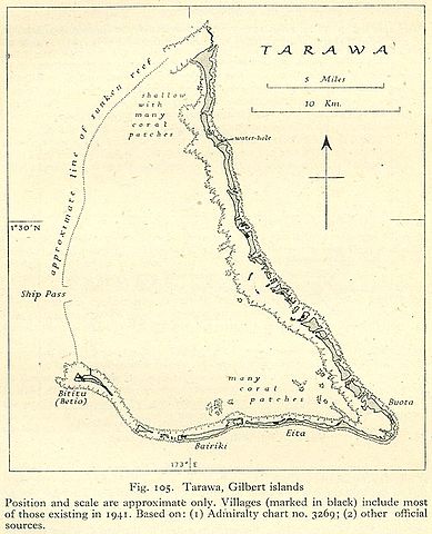
English: World War II map of Tarawa Atoll, Gilbert Islands, Kiribati, Pacific Ocean
Public domain, as explained on page http://www.lib.utexas.edu/usage_statement.html?maps=yes: "Most of the maps scanned by the University of Texas Libraries and served from this web site are in the public domain. No permissions are needed to copy them. You may download them and use them as you wish. A few maps are copyrighted, and are clearly marked as such." |
| Date | between 1943 and 1945 |
| Source | http://www.lib.utexas.edu/maps/historical/pacific_islands_1943_1945/tarawa.jpg |
| Author | Unknown author |
Licensing[edit]
This file is in the public domain because it has been taken from a collection of public domain maps at the University of Texas Library
|
File history
Click on a date/time to view the file as it appeared at that time.
| Date/Time | Thumbnail | Dimensions | User | Comment | |
|---|---|---|---|---|---|
| current | 14:43, 16 June 2012 | | 643 × 794 (119 KB) | Ratzer (talk | contribs) | {{Information |Description ={{en|1=World War II map of Tarawa Atoll, Gilbert Islands, Kiribati, Pacific Ocean}} |Source =http://www.lib.utexas.edu/maps/historical/pacific_islands_1943_1945/tarawa.jpg |Author =unknown |Date ... |
You cannot overwrite this file.
File usage on Commons
There are no pages that use this file.