File:The Mid-Atlantic States.png
Jump to navigation
Jump to search

Size of this preview: 800 × 520 pixels. Other resolutions: 320 × 208 pixels | 640 × 416 pixels | 1,024 × 665 pixels | 1,513 × 983 pixels.
Original file (1,513 × 983 pixels, file size: 43 KB, MIME type: image/png)
Captions
Captions
Add a one-line explanation of what this file represents
Summary[edit]
| Description |
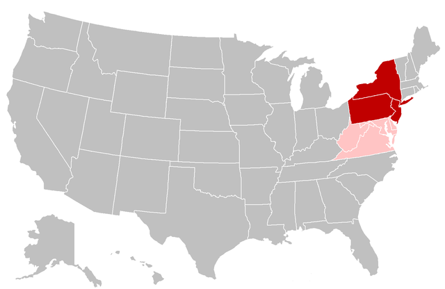
English: Map of the Mid-Atlantic United States. Red shading indicates the states most commonly defined as the Mid-Atlantic in their entirety (i.e. the southern portion of the Northeast) by public sector agencies and private organizations. Pink shading indicates states that are grouped in the region less frequently. |
| Date | |
| Source | Modified from: File:BlankMap-USA-states.PNG |
| Author | Grayshi, Roke, Maher-shalal-hashbaz |
Licensing[edit]
This file is licensed under the Creative Commons Attribution-Share Alike 3.0 Unported license.
- You are free:
- to share – to copy, distribute and transmit the work
- to remix – to adapt the work
- Under the following conditions:
- attribution – You must give appropriate credit, provide a link to the license, and indicate if changes were made. You may do so in any reasonable manner, but not in any way that suggests the licensor endorses you or your use.
- share alike – If you remix, transform, or build upon the material, you must distribute your contributions under the same or compatible license as the original.
File history
Click on a date/time to view the file as it appeared at that time.
| Date/Time | Thumbnail | Dimensions | User | Comment | |
|---|---|---|---|---|---|
| current | 01:33, 11 February 2023 | | 1,513 × 983 (43 KB) | Estshr (talk | contribs) | Maryland and Delaware are Southern states per the US Census Bureau Reverted to version as of 20:03, 3 November 2019 (UTC) |
| 06:03, 25 January 2023 |  | 1,513 × 983 (28 KB) | JsfasdF252 (talk | contribs) | Delaware, Maryland, and DC are included in the region more often then Virginias, but not as often as NJ/NY/PA (also fixed West Virginia color) | |
| 20:03, 3 November 2019 |  | 1,513 × 983 (43 KB) | Rubensbathsheba (talk | contribs) | Delaware, Maryland, and Washington D.C are Southeastern states. | |
| 16:47, 30 August 2017 |  | 1,513 × 983 (36 KB) | 007bond (talk | contribs) | User created page with UploadWizard |
You cannot overwrite this file.
File usage on Commons
The following page uses this file:
File usage on other wikis
The following other wikis use this file:
- Usage on ar.wikipedia.org
- Usage on ca.wikipedia.org
- Usage on en.wikipedia.org
- Usage on eo.wikipedia.org
- Usage on es.wikipedia.org
- Usage on et.wikipedia.org
- Usage on fr.wikivoyage.org
- Usage on gl.wikipedia.org
- Usage on hy.wikipedia.org
- Usage on id.wikipedia.org
- Usage on ko.wikipedia.org
- Usage on ru.wikipedia.org
- Usage on sr.wikipedia.org
- Usage on uk.wikipedia.org
- Usage on www.wikidata.org
- Usage on zh.wikipedia.org