File:The Town Hall, High Street, Garstang - geograph.org.uk - 436225.jpg
Jump to navigation
Jump to search

Size of this preview: 438 × 599 pixels. Other resolutions: 175 × 240 pixels | 468 × 640 pixels.
Original file (468 × 640 pixels, file size: 74 KB, MIME type: image/jpeg)
Captions
Captions
Add a one-line explanation of what this file represents
Summary[edit]
| Description |
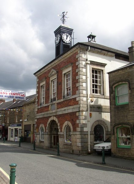
English: The Town Hall, High Street, Garstang First built in 1680, but burnt down in 1750 and rebuilt in 1755. The ground floor market hall is now used as shops, and there is a club upstairs. A plaque commemorates the Jubilee of Queen Victoria in 1887. The clock tower is of timber. |
| Date | |
| Source | From geograph.org.uk |
| Author | Humphrey Bolton |
| Attribution (required by the license) | Humphrey Bolton / The Town Hall, High Street, Garstang / |
| Camera location | | View this and other nearby images on: OpenStreetMap |
|---|
_heading:45.00&language=en)
| Object location | | View this and other nearby images on: OpenStreetMap |
|---|
_heading:45.00&language=en)
Licensing[edit]

|
This image was taken from the Geograph project collection. See this photograph's page on the Geograph website for the photographer's contact details. The copyright on this image is owned by Humphrey Bolton and is licensed for reuse under the Creative Commons Attribution-ShareAlike 2.0 license.
|
This file is licensed under the Creative Commons Attribution-Share Alike 2.0 Generic license.
Attribution: Humphrey Bolton
- You are free:
- to share – to copy, distribute and transmit the work
- to remix – to adapt the work
- Under the following conditions:
- attribution – You must give appropriate credit, provide a link to the license, and indicate if changes were made. You may do so in any reasonable manner, but not in any way that suggests the licensor endorses you or your use.
- share alike – If you remix, transform, or build upon the material, you must distribute your contributions under the same or compatible license as the original.
File history
Click on a date/time to view the file as it appeared at that time.
| Date/Time | Thumbnail | Dimensions | User | Comment | |
|---|---|---|---|---|---|
| current | 09:17, 4 February 2011 | | 468 × 640 (74 KB) | GeographBot (talk | contribs) | == {{int:filedesc}} == {{Information |description={{en|1=The Town Hall, High Street, Garstang First built in 1680, but burnt down in 1750 and rebuilt in 1755. The ground floor market hall is now used as shops, and there is a club upstairs. A plaque co |
You cannot overwrite this file.
File usage on Commons
There are no pages that use this file.
File usage on other wikis
The following other wikis use this file:
- Usage on en.wikipedia.org
- Borough of Wyre
- Rossall School
- RNAS Inskip (HMS Nightjar)
- Pharos Lighthouse, Fleetwood
- Shard Bridge
- Beach Lighthouse, Fleetwood
- Wyre Light
- Greenhalgh Castle
- Fleetwood Pier
- List of city and town halls in England
- Listed buildings in Poulton-le-Fylde
- St Chad's Church, Poulton-le-Fylde
- St Michael's Church, St Michael's on Wyre
- Church of St John the Evangelist, Poulton-le-Fylde
- Old St John the Baptist's Church, Pilling
- St John the Baptist's Church, Pilling
- Listed buildings in Fleetwood
- St Peter's Church, Fleetwood
- St Mary's Church, Fleetwood
- St Nicholas Church, Fleetwood
- Wyresdale Park
- St Oswald's Church, Preesall
- Church of St Mary and St Michael, Bonds
- Marsh Mill
- St Helen's Church, Churchtown
- Fleetwood Museum
- North Euston Hotel
- St Thomas' Church, Garstang
- St Peter's Church, Scorton
- St Luke's Church, Winmarleigh
- All Saints Church, Barnacre
- Cartford Bridge
- St Hilda's Church, Bilsborrow
- Christ Church, Thornton
- Winmarleigh Hall
- Rossall Point Observation Tower
- Listed buildings in Barnacre-with-Bonds
- Listed buildings in Bleasdale
- Listed buildings in Cabus
- Listed buildings in Catterall
- Listed buildings in Claughton, Wyre
- Listed buildings in Forton, Lancashire
- Listed buildings in Garstang
- Listed buildings in Great Eccleston
- Listed buildings in Hambleton, Lancashire
- Listed buildings in Inskip-with-Sowerby
- Listed buildings in Kirkland, Lancashire
- Listed buildings in Myerscough and Bilsborrow
- Listed buildings in Nateby, Lancashire
- Listed buildings in Nether Wyresdale
View more global usage of this file.