File:Topographic map of the districts of Socotra (de).svg
Jump to navigation
Jump to search

Size of this PNG preview of this SVG file: 800 × 229 pixels. Other resolutions: 320 × 92 pixels | 640 × 183 pixels | 1,024 × 293 pixels | 1,280 × 367 pixels | 2,560 × 733 pixels | 1,309 × 375 pixels.
Original file (SVG file, nominally 1,309 × 375 pixels, file size: 412 KB)
Captions
Captions
Add a one-line explanation of what this file represents
Summary[edit]
| Description |
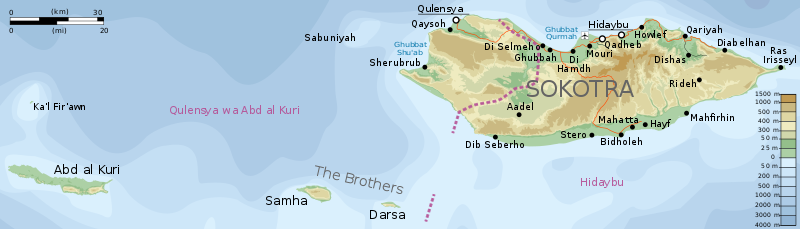
English: Topographic map of the districts of Socotra.
Deutsch: Topographische Karte der Distrikte von Sokotra.
Français : Carte topographique des départements de Socotra.
Македонски: Топографска карта на Сокотра.
Suomi: Sokotran topografinen kartta.
Русский: Топографическая карта Сокотры |
||
| Date | |||
| Source |
Self-made in Inkscape. |
||
| Author | Oona Räisänen (Mysid) | ||
| Permission (Reusing this file) |
I, the copyright holder of this work, hereby publish it under the following licenses:
This file is licensed under the Creative Commons Attribution-Share Alike 4.0 International, 3.0 Unported, 2.5 Generic, 2.0 Generic and 1.0 Generic license.
You may select the license of your choice. |
||
| Other versions |
|

.svg&action=edit§ion=1)
.svg)
|
This SVG file contains embedded text that can be translated into your language, using any capable SVG editor, text editor or the SVG Translate tool. For more information see: About translating SVG files. |
.svg)
File history
Click on a date/time to view the file as it appeared at that time.
| Date/Time | Thumbnail | Dimensions | User | Comment | |
|---|---|---|---|---|---|
| current | 23:57, 1 July 2017 | 1,309 × 375 (412 KB) | Furfur (talk | contribs) | == {{int:filedesc}} == {{Information |Description= {{en|Topographic map of the districts of Socotra.}} {{de|Topographische Karte der Distrikte von Sokotra.}} {{fr|Carte topographique des départements de [[:fr:Socotra|So... |
You cannot overwrite this file.
File usage on Commons
The following page uses this file:
File usage on other wikis
The following other wikis use this file:
- Usage on de.wikipedia.org
- Usage on frr.wikipedia.org
- Usage on it.wikipedia.org
- Usage on zh.wikipedia.org
.svg&oldid=631390880)