File:Transvaal railway map 1899.svg
Jump to navigation
Jump to search

Size of this PNG preview of this SVG file: 800 × 498 pixels. Other resolutions: 320 × 199 pixels | 640 × 398 pixels | 1,024 × 637 pixels | 1,280 × 796 pixels | 2,560 × 1,593 pixels | 982 × 611 pixels.
Original file (SVG file, nominally 982 × 611 pixels, file size: 104 KB)
Captions
Captions
Add a one-line explanation of what this file represents
| Description |
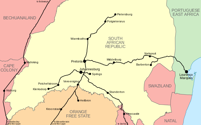
English: Map of the railway network of the en:South African Republic (Transvaal), as it stood in 1899 at the outbreak of the Anglo-Boer War. |
|||
| Date | ||||
| Source |
|
|||
| Author | Htonl | |||
| Permission (Reusing this file) |
I, the copyright holder of this work, hereby publish it under the following license: This file is licensed under the Creative Commons Attribution-Share Alike 4.0 International and 3.0 Unported license.
|
|||
| Other versions | File:NZASM line map.svg |
File history
Click on a date/time to view the file as it appeared at that time.
| Date/Time | Thumbnail | Dimensions | User | Comment | |
|---|---|---|---|---|---|
| current | 21:19, 29 January 2013 | | 982 × 611 (104 KB) | Htonl (talk | contribs) | ocean colour |
| 15:50, 29 January 2013 |  | 982 × 611 (104 KB) | Htonl (talk | contribs) | remove Zululand label; it had been incorporated into Natal by 1899 | |
| 01:17, 29 January 2013 |  | 982 × 611 (105 KB) | Htonl (talk | contribs) | {{Information |Description ={{en|1=Map of the railway network of the en:South African Republic (Transvaal), as it stood in 1899 at the outbreak of the Anglo-Boer War.}} |Source =* Own work * OpenStreetMap data used for railway lines |Au... |
You cannot overwrite this file.
File usage on Commons
The following page uses this file:
File usage on other wikis
The following other wikis use this file:
- Usage on de.wikipedia.org
- Usage on nl.wikipedia.org