File:Trebizond1300.png
Jump to navigation
Jump to search
No higher resolution available.
Trebizond1300.png (552 × 392 pixels, file size: 67 KB, MIME type: image/png)
Captions
Captions
Add a one-line explanation of what this file represents
Summary[edit]
| Description |
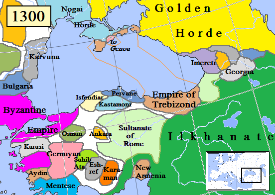
English: Map of the Trebizond Empire in Anatolia, AD 1300.
(Partially based on Euratlas map of Europe, 1300.) |
| Date | |
| Source | Own work |
| Author | Gabagool |

|
This historical map image could be re-created using vector graphics as an SVG file. This has several advantages; see Commons:Media for cleanup for more information. If an SVG form of this image is available, please upload it and afterwards replace this template with
{{vector version available|new image name}}.
It is recommended to name the SVG file “Trebizond1300.svg”—then the template Vector version available (or Vva) does not need the new image name parameter. |
Licensing[edit]
I, the copyright holder of this work, hereby publish it under the following license:
This file is licensed under the Creative Commons Attribution 3.0 Unported license.
- You are free:
- to share – to copy, distribute and transmit the work
- to remix – to adapt the work
- Under the following conditions:
- attribution – You must give appropriate credit, provide a link to the license, and indicate if changes were made. You may do so in any reasonable manner, but not in any way that suggests the licensor endorses you or your use.
File history
Click on a date/time to view the file as it appeared at that time.
| Date/Time | Thumbnail | Dimensions | User | Comment | |
|---|---|---|---|---|---|
| current | 15:21, 12 August 2023 | | 552 × 392 (67 KB) | Gyalu22 (talk | contribs) | Reverted to version as of 16:24, 16 November 2022 (UTC) Wallachia was not part of the Second Bulgarian Empire, see https://www.google.com/search?q=europe+map+1300 |
| 15:09, 12 May 2023 |  | 564 × 404 (143 KB) | Moodylo333 (talk | contribs) | Correct borders & states year 1300 | |
| 16:24, 16 November 2022 |  | 552 × 392 (67 KB) | Gyalu22 (talk | contribs) | Reverted to version as of 00:49, 13 December 2012 (UTC) | |
| 17:46, 15 August 2019 |  | 552 × 392 (94 KB) | Georgiano (talk | contribs) | Reverted to version as of 17:44, 15 August 2019 (UTC) correct source: File:Map–Principality of Samtskhe till c.1325–ka.svg | |
| 17:45, 15 August 2019 |  | 552 × 392 (89 KB) | Georgiano (talk | contribs) | Reverted to version as of 23:21, 2 April 2016 (UTC) | |
| 17:44, 15 August 2019 |  | 552 × 392 (94 KB) | Georgiano (talk | contribs) | added Principality of Samtskhe (vassal of Ilkhanate between 1266–1334) source: File:Caucasus 1311 AD map de.png | |
| 23:21, 2 April 2016 |  | 552 × 392 (89 KB) | Julieta39 (talk | contribs) | Cosmetic work, add Amastris, Montecastro, Caffa & Cembalo (to Genoa) and some details according with Claude Mutafian & Eric Van Lauwe’s « Atlas Historique de l’Armenie », Paris, ed. Autrement 2001, ISBN 2-7467-0100-6 | |
| 20:06, 14 March 2016 |  | 552 × 392 (75 KB) | Georgiano (talk | contribs) | fixed borders of Georgian kingdoms | |
| 10:25, 17 July 2015 |  | 552 × 392 (89 KB) | Spiridon Ion Cepleanu (talk | contribs) | Little rectifications. according with H.E.Stier's (dir.) « Westermann Grosser Atlas zur Weltgeschichte », 1985, ISBN 3-14-100919-8 for the year 1300 | |
| 00:49, 13 December 2012 |  | 552 × 392 (67 KB) | Geagea (talk | contribs) | Reverted to version as of 19:54, 30 March 2009 |
You cannot overwrite this file.
File usage on Commons
The following 3 pages use this file:
- User:Jaqeli/Georgia
- File:Trapezunt1300.png (file redirect)
- Category:Empire of Trebizond
File usage on other wikis
The following other wikis use this file:
- Usage on ar.wikipedia.org
- Usage on azb.wikipedia.org
- Usage on az.wikipedia.org
- Usage on be.wikipedia.org
- Usage on bg.wikipedia.org
- Usage on cs.wikipedia.org
- Usage on diq.wikipedia.org
- Usage on dsb.wikipedia.org
- Usage on el.wikipedia.org
- Usage on en.wikipedia.org
- Usage on es.wikipedia.org
- Usage on et.wikipedia.org
- Usage on eu.wikipedia.org
- Usage on fa.wikipedia.org
- Usage on fiu-vro.wikipedia.org
- Usage on fr.wikipedia.org
- Usage on gl.wikipedia.org
- Usage on hr.wikipedia.org
- Usage on hu.wikipedia.org
- Usage on hy.wikipedia.org
- Usage on id.wikipedia.org
- Usage on it.wikipedia.org
- Usage on ka.wikipedia.org
- Usage on ku.wikipedia.org
- Usage on lt.wikipedia.org
- Usage on mk.wikipedia.org
- Usage on ms.wikipedia.org
- Usage on nl.wikipedia.org
View more global usage of this file.