File:Wells Fargo and Company Building, Main and Washington Streets (Columbia State Historical Park), Columbia, Tuolumne County, HABS CAL,55-COLUM,3- (sheet 9 of 11).tif
Jump to navigation
Jump to search

Size of this JPG preview of this TIF file: 781 × 600 pixels. Other resolutions: 313 × 240 pixels | 625 × 480 pixels | 1,001 × 768 pixels | 1,280 × 983 pixels | 2,560 × 1,965 pixels | 9,296 × 7,136 pixels.
Original file (9,296 × 7,136 pixels, file size: 694 KB, MIME type: image/tiff)
Captions
Captions
Add a one-line explanation of what this file represents
Summary[edit]
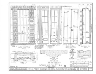
| HABS CAL,55-COLUM,3- (sheet 9 of 11) - Wells Fargo and Company Building, Main and Washington Streets (Columbia State Historical Park), Columbia, Tuolumne County, CA | ||||
|---|---|---|---|---|
| Title |
HABS CAL,55-COLUM,3- (sheet 9 of 11) - Wells Fargo and Company Building, Main and Washington Streets (Columbia State Historical Park), Columbia, Tuolumne County, CA |
|||
| Depicted place | California; Tuolumne County; Columbia | |||
| Date | Documentation compiled after 1933 | |||
| Dimensions | 19 x 24 in. (B size) | |||
| Current location |
Library of Congress Prints and Photographs Division Washington, D.C. 20540 USA http://hdl.loc.gov/loc.pnp/pp.print |
|||
| Accession number |
HABS CAL,55-COLUM,3- (sheet 9 of 11) |
|||
| Credit line |
|
|||
| Notes |
|
|||
| Source | https://www.loc.gov/pictures/item/ca1156.sheet.00009a | |||
| Permission (Reusing this file) |
|
|||

| Object location | | View this and other nearby images on: OpenStreetMap |
|---|
File history
Click on a date/time to view the file as it appeared at that time.
| Date/Time | Thumbnail | Dimensions | User | Comment | |
|---|---|---|---|---|---|
| current | 11:47, 2 July 2014 |  | 9,296 × 7,136 (694 KB) | Fæ (talk | contribs) | GWToolset: Creating mediafile for Fæ. HABS batch upload 2 July 2014 (301:400) |
You cannot overwrite this file.
File usage on Commons
The following 2 pages use this file:
- File:HABS CAL,55-COLUM,3- (sheet 9 of 11) - Wells Fargo and Company Building, Main and Washington Streets (Columbia State Historical Park), Columbia, Tuolumne County, HABS CAL,55-COLUM,3- (sheet 9 of 11).tif (file redirect)
- File:Wells Fargo and Company Building, Main and Washington Streets (Columbia State Historical Park), Columbia, Tuolumne County, HABS CAL,55-COLUM,3- (sheet 9 of 11).tif