File:Westray to Papa Westray air route map.png
跳至導覽
跳至搜尋

預覽大小:467 × 599 像素。 其他解析度:187 × 240 像素 | 374 × 480 像素 | 667 × 856 像素。
原始檔案 (667 × 856 像素,檔案大小:192 KB,MIME 類型:image/png)
說明
說明
添加單行說明來描述出檔案所代表的內容
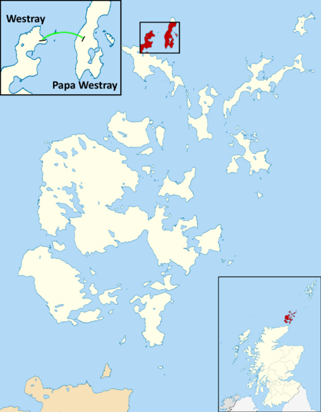
A map depicting the Westray to Papa Westray air route.
摘要
[編輯]
| 描述 |
English: This is a map depicting the shortest scheduled airline flight in the world as of December, 2016. The record was established in 1967. The flight goes between two islands in Orkney, Scotland: Westray and Papa Westray. |
| 日期 | |
| 來源 | 自己的作品 |
| 作者 | Dcs002 |
I believe I am the copyright holder because I used a Wikimedia Commons image (File:Orkney_Islands_UK_blank_map.svg) and substantially altered it myself. I release the work I have added to it under the license above. The image I began with is posted under the "Creative Commons Attribution-Share Alike 3.0 Unported license", which is why I selected that license. I am not experienced enough in these matters to select the correct license based on the work I altered. I do not care to retain any rights for myself. I just want this image (or a similar image) for the Wikipedia article about the flight. Please help if I have done this incorrectly.
授權條款
[編輯]
我,本作品的著作權持有者,決定用以下授權條款發佈本作品:
此檔案採用創用CC 姓名標示-相同方式分享 3.0 未在地化版本授權條款。
- 您可以自由:
- 分享 – 複製、發佈和傳播本作品
- 重新修改 – 創作演繹作品
- 惟需遵照下列條件:
- 姓名標示 – 您必須指名出正確的製作者,和提供授權條款的連結,以及表示是否有對內容上做出變更。您可以用任何合理的方式來行動,但不得以任何方式表明授權條款是對您許可或是由您所使用。
- 相同方式分享 – 如果您利用本素材進行再混合、轉換或創作,您必須基於如同原先的相同或兼容的條款,來分布您的貢獻成品。
檔案歷史
點選日期/時間以檢視該時間的檔案版本。
| 日期/時間 | 縮圖 | 尺寸 | 使用者 | 備註 | |
|---|---|---|---|---|---|
| 目前 | 2017年4月18日 (二) 20:17 | | 667 × 856(192 KB) | Maproom(留言 | 貢獻) | Adjusted map to show the Loch of St. Tredwell as a freshwater loch, not a sea loch. |
| 2016年12月21日 (三) 01:56 |  | 667 × 856(284 KB) | Dcs002(留言 | 貢獻) | User created page with UploadWizard |
無法覆蓋此檔案。
檔案用途
全域檔案使用狀況
以下其他 wiki 使用了這個檔案:
- en.wikipedia.org 的使用狀況
- hu.wikipedia.org 的使用狀況
- vi.wikipedia.org 的使用狀況
- zh.wikipedia.org 的使用狀況