File:Zanjan Counties Map.png
Jump to navigation
Jump to search

Size of this preview: 634 × 599 pixels. Other resolutions: 254 × 240 pixels | 508 × 480 pixels | 813 × 768 pixels | 1,084 × 1,024 pixels | 2,167 × 2,048 pixels | 3,449 × 3,259 pixels.
Original file (3,449 × 3,259 pixels, file size: 161 KB, MIME type: image/png)
Captions
Captions
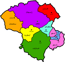
Administrative division map: counties of zanjan
Summary
[edit]
| Description |
English: Administrative division map: counties of Zanjan until May 2020 |
| Date | |
| Source | Own work |
| Author | Hadi94K |
Licensing
[edit]
I, the copyright holder of this work, hereby publish it under the following license:
This file is licensed under the Creative Commons Attribution-Share Alike 4.0 International license.
- You are free:
- to share – to copy, distribute and transmit the work
- to remix – to adapt the work
- Under the following conditions:
- attribution – You must give appropriate credit, provide a link to the license, and indicate if changes were made. You may do so in any reasonable manner, but not in any way that suggests the licensor endorses you or your use.
- share alike – If you remix, transform, or build upon the material, you must distribute your contributions under the same or compatible license as the original.
File history
Click on a date/time to view the file as it appeared at that time.
| Date/Time | Thumbnail | Dimensions | User | Comment | |
|---|---|---|---|---|---|
| current | 17:41, 25 April 2021 | | 3,449 × 3,259 (161 KB) | Hadi94K (talk | contribs) | Uploaded own work with UploadWizard |
You cannot overwrite this file.
File usage on Commons
The following page uses this file:
- File:ZANJAN.png (file redirect)
File usage on other wikis
The following other wikis use this file:
- Usage on fa.wikipedia.org
- زنجان
- استان زنجان
- شهرستان طارم
- ابهر
- خرمدره
- هیدج
- صایینقلعه
- شهرستان زنجان
- شهرستان خدابنده
- شهرستان ماهنشان
- شهرستان خرمدره
- شهرستان ابهر
- غار کتلهخور
- سجاس
- ماهنشان
- الگو:استان زنجان
- شهرستان ایجرود
- مردان نمکی
- گنبد سلطانیه
- بنای رختشویخانه
- زرینآباد
- حلب (زنجان)
- گرماب (خدابنده)
- چورزق
- آببر (زنجان)
- دندی
- بازار زنجان
- بخش مرکزی شهرستان ابهر
- بخش مرکزی شهرستان سلطانیه
- بخش مرکزی شهرستان خدابنده
- بخش افشار
- بخش بزینهرود
- بخش سجاسرود
- بخش زنجانرود
- بخش قرهپشتلو
- بخش مرکزی شهرستان ایجرود
- بخش حلب
- بخش مرکزی شهرستان طارم
- بخش چورزق
- بخش مرکزی شهرستان ماهنشان
- بخش انگوران
- حسینیه اعظم زنجان
- مسجد جامع زنجان
- قلعه بهستان
- مجموعه تفریحی گاوازنگ زنجان
- سهرورد
- ارمغانخانه
- آبشار شارشار
- فهرست شهرهای استان زنجان
- سلطانیه
View more global usage of this file.