Maps of Ukraine
(Redirected from Historical maps of Ukraine)
Countries of Europe: Albania · Andorra · Armenia‡ · Austria · Azerbaijan‡ · Belarus · Belgium · Bosnia and Herzegovina · Bulgaria · Croatia · Cyprus‡ · Czech Republic · Denmark · Estonia · Finland · France‡ · Georgia‡ · Germany · Greece · Hungary · Iceland · Republic of Ireland · Italy · Kazakhstan‡ · Latvia · Lithuania · Luxembourg · Malta · Monaco · Netherlands‡ · North Macedonia · Norway · Poland · Portugal‡ · Romania · Russia‡ · San Marino · Slovakia · Slovenia · Spain‡ · Sweden · Switzerland · Turkey‡ · Ukraine · United Kingdom · Vatican City
Specific status: Faroe Islands · Gibraltar · Isle of Man – Limited recognition: Abkhazia‡ · Kosovo
‡: partly located in Europe
Specific status: Faroe Islands · Gibraltar · Isle of Man – Limited recognition: Abkhazia‡ · Kosovo
‡: partly located in Europe
Maps of Ukraine. For versions in your langugage contact Steschke.
General[edit]
-
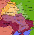
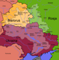
 Location of Ukraine
 -
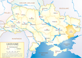
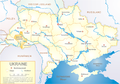
 Simple map blank
 -
 Ukrainian oblast capitals (English)
 -
 Ukrainian oblast capitals (Polish)
 -
 English map from CIA's World Factbook
 -
 English map Numbered
 -
 Ethnic Ukrainians in Ukraine (2001)


.png)


Regions[edit]
-
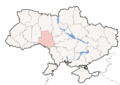
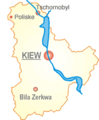 Map of Kiev district (oblast), region of Chornobyl. Location of Poliske
 -
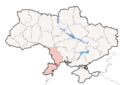
 Donbass region
 -
 Carpathians
 -
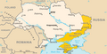
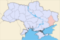
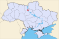
 Zaporizhzhia
 -
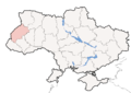
 Galicia and Volhynia
 -
 Donets Basin
 -
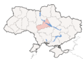
 Sloboda Ukraine
 -
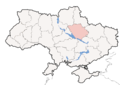
 Podolia
 -
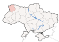
 Polesia
 -
 Ukraine Black Sea Lands


Oblasts[edit]
Oblast locations[edit]
-
 Oblast Charkiw
 -
 Oblast Czernowitz
 -
 Oblast Donezk
 -
 Oblast Iwano-Frankiwsk
 -
 Oblast Kiew
 -
 Oblast Krim
 -
 Oblast Lemberg
 -
 Oblast Rivne
 -
 Oblast Schytomyr
 -
 City Sewastopol
 -
 Oblast Ternopil
 -
 Oblast Transkarpatien
 -
 Oblast Tscherkasy
 -
 Oblast Wolhynien
 -
 Oblast Cherson
 -
 Oblast Chmelnyzkyj
 -
 Oblast Dnipropetrowsk
 -
 Oblast Kirowohrad
 -
 Oblast Luhansk
 -
 Oblast Poltawa
 -
 Oblast Sumy
 -
 Oblast Tschernihiw
 -
 Oblast Wynnyzja
 -
 city Kiew
 -
 Oblast Mykolajiw
 -
 Oblast Odessa
 -
 Oblast Saporischja


Rivers[edit]
-
 Oblast Volynsk
 -
 Oblast Kiev
 -
 Oblast Zhytomyr
 -
 Oblast Transcarpathia
 -
 Oblast Lviv (Lwiw)
 -
 Dnepr-Basin (ukrainian)
 -
 Dnepr-Basin (deutsch)
 -
 Dnepr-Basin (polish)
 -
 Dnepr-Basin (french)
 -
 Dnepr-Basin (english/kyrill)
 -
 Dnepr-Basin (swedish)
 -
 Dnepr-Basin (blank version)


Raion borders[edit]
-
 Oblast Volynsk
 -
 Oblast Rivne
 -
 Oblast Lviv
 -
 Ivano-Frankivsk
 -
 Oblast Transcarpathia
 -
 Oblast Kirovograd
 -
 Oblast Cherkasy
 -
 Oblast Saporischja
 -
 Oblast Saporischja


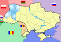
Deutsch/German[edit]
-
 Oblast Kiew
 -
 Oblast Riwne
 -
 Oblast Schytomyr
 -
 Oblast Ternopil
 -
 Oblast Transkarpatien
 -
 Oblast Tscherkasy
 -
 Oblast Wolhynien
 -
 Oblast Donezk
 -
 Oblast Lemberg
 -
 Oblast Charkiw
 -
 Oblast Iwano-Frankiwsk
 -
 Oblast Czernowitz


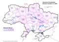
Presidential election, 2004[edit]
-
 Presidential election first vote 2004-10-30
 -
 Presidential election runoff vote 2004-11-21
 -
 Presidential election second runoff vote 2004-12-26
 -
 en:Presidential election second runoff vote 2004-12-26


First round[edit]
-
 Viktor Yushchenko (First round) - percentage of total national vote
 -
 Viktor Yanukovych (First round) - percentage of total national vote
 -
 Olexandr Moroz (First round) - percentage of total national vote
.png)
.png)
.png)
Run-off[edit]
-
 Viktor Yushchenko (Second round) - percentage of total national vote
 -
 Viktor Yanukovych (Second round) - percentage of total national vote
.png)
.png)
Final Round[edit]
-
 Viktor Yushchenko (Final round) - percentage of total national vote
 -
 Viktor Yanukovych (Final round) - percentage of total national vote
.png)
.png)
Parliamentary election, 2006[edit]
-
 Ukraine, Non-administrative regional division used by KIIS

Maps showing the top five candidates support in the first round of voting- percentage of total national vote
-
 Party of Regions results (32.14%) Percentage of total national vote
 -
 Bloc Yulia Tymoshenko results (22.29%) Percentage of total national vote
 -
 Our Ukraine results (13.95%) Percentage of total national vote
 -
 Socialist Party of Ukraine results (5.69%) Percentage of total national vote
 -
 Communist Party of Ukraine results (3.66%) Percentage of total national vote
v.PNG)
v.PNG)
v.PNG)
v.PNG)
v.PNG)
Parliamentary election, 2007[edit]
Maps showing the top six candidates support in the first round of voting- percentage of total national vote
-
 Party of Regions results (34.37%)
 -
 Bloc Yulia Tymoshenko results (30.71%)
 -
 Our Ukraine People's Self-Defence results (14.15%)
 -
 Communist Party of Ukraine results (5.39%)
 -
 Bloc Lytvyn Party results (3.96%)
 -
 Socialist Party of Ukraine results (2.86%)
v.PNG)
v.PNG)
v.PNG)
v.PNG)
v.PNG)
v.PNG)
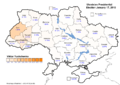
Presidential election, 2010[edit]
Maps showing the top five candidates support in the first round of voting- percentage of total national vote
First round[edit]
-
 Viktor Yanukovych (First round) - percentage of total national vote (35.33%)
 -
 Yulia Tymoshenko (First round) - percentage of total national vote (25.05%)
 -
 Serhiy Tihipko (First round) - percentage of total national vote (13.06%)
 -
 Arseniy Yatsenyuk (First round) - percentage of total national vote (6.69%)
 -
 Viktor Yushchenko (First round) - percentage of total national vote (5.46%)
 -
 Total vote distribution (First round) - percentage of total national vote
.png)
.png)
.png)
.png)
.png)
.png)
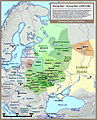
Historical maps[edit]
-
 European territory inahibted by East Slavic tribes in 8th and 9th century.
 -
 Principalities of Kievan Rus' (1054-1132).
 -
 Kievan Rus 13th Century
 -
 The Kingdom of Galicia–Volhynia (1245-1349).
 -
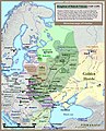
 Grand Duchy of Lithuania, Rus' (Ukraine) and Samogitia (1386-1434).
 -
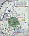
 Historical map of Polish–Lithuanian–Ruthenian Commonwealth or Commonwealth of Three Nations (1658).
 -
 Historical map of Ukrainian Cossack Hetmanate and territory of Zaporozhian Cossacks under rule of Russian Empire (1751).
 -
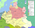
 Polish-Lithuanian Commonwealth in 17th and 18th century
 -
 Polish-Lithuanian Commonwealth - administrative division
 -
 Volynsk (blank)
 -
 Karte des Fürstentums Wolhynien
 -
 Volynsk/Wolhynien 1921-1939 part of Poland/Teil von Polen
 -
 Poland Galicia Volyna
 -
 Kudin hill fort

.jpg)


