File:ארץ ישראל Erez Israel (FL197701839 1100165).jpg
קפיצה לניווט
קפיצה לחיפוש

גודל התצוגה המקדימה הזאת: 421 × 599 פיקסלים. רזולוציות אחרות: 168 × 240 פיקסלים | 337 × 480 פיקסלים | 539 × 768 פיקסלים | 719 × 1,024 פיקסלים | 1,438 × 2,048 פיקסלים | 11,122 × 15,834 פיקסלים.
לקובץ המקורי (11,122 × 15,834 פיקסלים, גודל הקובץ: 242.21 מ"ב, סוג MIME: image/jpeg)
כיתובים
כיתובים
נא להוסיף משפט שמסביר מה הקובץ מייצג
תקציר
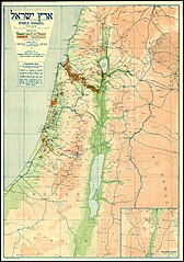
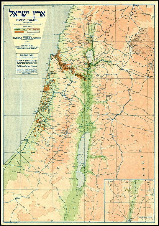
[עריכה]| ארץ ישראל Erez Israel
( |
||||||||||||||||||||||||
|---|---|---|---|---|---|---|---|---|---|---|---|---|---|---|---|---|---|---|---|---|---|---|---|---|
| כותרת |
ארץ ישראל Erez Israel |
|||||||||||||||||||||||
| מפרסם |
Head Office of the Keren Kayemeth Leisrael |
|||||||||||||||||||||||
| תיאור |
ארץ ישראל Erez Israel.. |
|||||||||||||||||||||||
| שפה | אנגלית | |||||||||||||||||||||||
| תאריך הוצאה לאור | 1934 | |||||||||||||||||||||||
| טכניקה | 1 sheet : color ; | |||||||||||||||||||||||
| ממדים | גובה: 66 ס"מ; רוחב: 46 ס"מ | |||||||||||||||||||||||
| אוסף |
|
|||||||||||||||||||||||
| מיקום נוכחי |
|
|||||||||||||||||||||||
| מיקום הוצאה | ירושלים | |||||||||||||||||||||||
| חיפוש בקטלוג מרחב | ירושלים | |||||||||||||||||||||||
| הערות | See also Hebrew edition Pal 1361, English edition Pal 1361.1, German edition Pal 1361.3.; Inset: Southern Edom, scale 1:1,000,000 | |||||||||||||||||||||||
| קנה מידה | 1:500,000 cm | |||||||||||||||||||||||
| IE PID | IE197701837 | |||||||||||||||||||||||
| רוזטה שם קובץ | FL197701839 | |||||||||||||||||||||||
| מזהה רשומה בספרייה הלאומית (P3959) | 997011001656405171 | |||||||||||||||||||||||
| חיפוש בקטלוג מרחב | אנגלית | |||||||||||||||||||||||
| חיפוש בקטלוג מרחב | Erez Israelארץ ישראלLand tenureEretz IsraelMapsHead Office of the Keren Kayemeth Leisrael | |||||||||||||||||||||||
| מקור/צלם |
|
|||||||||||||||||||||||
| גרסאות אחרות | ||||||||||||||||||||||||
| Jpg / Tif version |
|
|||||||||||||||||||||||

.jpg)

.jpg&action=edit§ion=1)
רישיון
[עריכה].jpg&action=edit§ion=2)
This UK artistic or literary work, of which the author is unknown and cannot be ascertained by reasonable enquiry, is in the public domain because it is one of the following:
|
 |
היסטוריית הקובץ
ניתן ללחוץ על תאריך/שעה כדי לראות את הקובץ כפי שנראה באותו זמן.
| תאריך/שעה | תמונה ממוזערת | ממדים | משתמש | הערה | |
|---|---|---|---|---|---|
| נוכחית | 16:33, 2 בספטמבר 2023 | | 15,834 × 11,122 (242.21 מ"ב) | Geagea (שיחה | תרומות) | pattypan 22.03 |
אין באפשרותך לדרוס את הקובץ הזה.
שימוש בקובץ
הדף הבא משתמש בקובץ הזה:
.jpg&oldid=797858174)