File:A1 railway.png

לקובץ המקורי (1,596 × 1,204 פיקסלים, גודל הקובץ: 319 ק"ב, סוג MIME: image/png)
כיתובים
כיתובים
| תיאור |
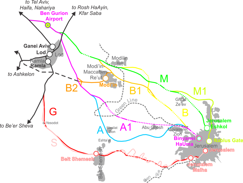
Map showing the plans for a Tel-Aviv--Jerusalem railway connection. Each alternative (S, G, A, A1, B, B1, B2, M, M1) is represented by a different color. Bold text and ciricles is for stations, while regular dark grey text is for city (12pt)/town (10pt)/village (8pt) names. Done with the help of a slew of other maps, not all of which had the same aspect ratio, etc. Therefore, try as I might, the map did not come out exactly to scale (probably) and has a few minor errors. The grey areas (built-up urban) are only shown for relevant localities, and are strictly demonstrative - they are generally not exact at all. Dotted lines denote tunnels. Bridges were not added, as I don't have the actual plans for these lines and the maps I have do not show bridges. |
| תאריך יצירה | |
| מקור | נוצר על־ידי מעלה היצירה |
| יוצר | Ynhockey |

|
מוענקת בכך הרשות להעתיק, להפיץ או לשנות את המסמך הזה, לפי תנאי הרישיון לשימוש חופשי במסמכים של גנו, גרסה 1.2 או כל גרסה מאוחרת יותר שתפורסם על־ידי המוסד לתוכנה חופשית; ללא פרקים קבועים, ללא טקסט עטיפה קדמית וללא טקסט עטיפה אחורית. עותק של הרישיון כלול בפרק שכותרתו הרישיון לשימוש חופשי במסמכים של גנו. |
| הקובץ הזה מתפרסם לפי תנאי רישיון קריאייטיב קומונז ייחוס-שיתוף זהה 3.0 לא מותאם. | ||
| ||
| תבנית רישוי זו הוספה לקובץ כחלק מעדכון רישיון GFDL. |
היסטוריית הקובץ
ניתן ללחוץ על תאריך/שעה כדי לראות את הקובץ כפי שנראה באותו זמן.
| תאריך/שעה | תמונה ממוזערת | ממדים | משתמש | הערה | |
|---|---|---|---|---|---|
| נוכחית | 10:44, 2 במאי 2016 | | 1,204 × 1,596 (319 ק"ב) | Ynhockey (שיחה | תרומות) | Small clarifications in accordance with article text |
| 17:26, 24 באפריל 2008 |  | 1,206 × 1,600 (305 ק"ב) | Ynhockey (שיחה | תרומות) | {{Information |Description=Map showing the plans for a Tel-Aviv--Jerusalem railway connection. Each plan (S, G, A, A1, B, B1, B2, M, M1) is represented by a different color. Bold text and ciricles is for stations, while regular dark grey text is for city |
אין באפשרותך לדרוס את הקובץ הזה.
שימוש בקובץ
הדפים הבאים משתמשים בקובץ הזה:
שימוש גלובלי בקובץ
אתרי הוויקי השונים הבאים משתמשים בקובץ זה:
- שימוש באתר ar.wikipedia.org
- שימוש באתר de.wikipedia.org
- שימוש באתר en.wikipedia.org
- שימוש באתר fr.wikipedia.org
- שימוש באתר he.wikipedia.org
- שימוש באתר ko.wikipedia.org
- שימוש באתר nl.wikivoyage.org
- שימוש באתר ru.wikipedia.org
- שימוש באתר tr.wikipedia.org
- שימוש באתר zh.wikipedia.org