File:Accurata Utopiae Tabula (FL173085858 3423220).jpg
קפיצה לניווט
קפיצה לחיפוש

גודל התצוגה המקדימה הזאת: 676 × 600 פיקסלים. רזולוציות אחרות: 270 × 240 פיקסלים | 541 × 480 פיקסלים | 865 × 768 פיקסלים | 1,154 × 1,024 פיקסלים | 2,308 × 2,048 פיקסלים | 14,542 × 12,906 פיקסלים.
לקובץ המקורי (14,542 × 12,906 פיקסלים, גודל הקובץ: 231.2 מ"ב, סוג MIME: image/jpeg)
כיתובים
כיתובים
נא להוסיף משפט שמסביר מה הקובץ מייצג
תקציר
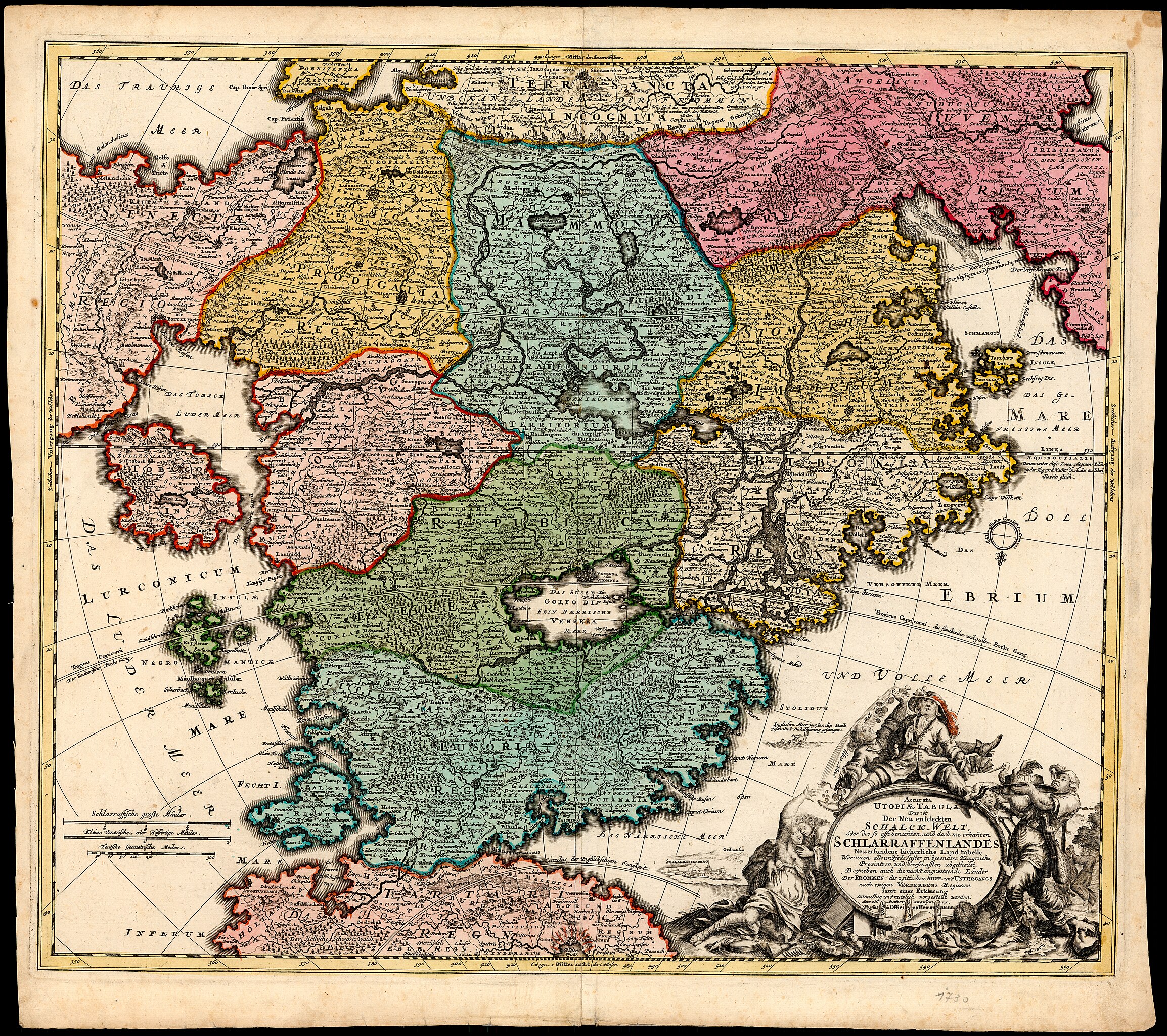
[עריכה]| Accurata Utopiae Tabula
( |
||||||||||||||||||||||||
|---|---|---|---|---|---|---|---|---|---|---|---|---|---|---|---|---|---|---|---|---|---|---|---|---|
| אומן |
| |||||||||||||||||||||||
| יוצרים נוספים | Homann, Johann Baptist, 1663-1724 | |||||||||||||||||||||||
| כותרת |
Accurata Utopiae Tabula |
|||||||||||||||||||||||
| מפרסם |
Officina Homanniana |
|||||||||||||||||||||||
| תיאור |
Accurata Utopiae Tabula : Das ist Der Neu-entdeckten Schalck-Welt oder des so offt benannten, und doch nie erkannten Schlaraffenlandes Neu-erfundene lächerliche Land-Tabell Worinnen all und jede Laster in besondere Königreich, Provintzien und Herrschafften abgetheilet Beyneben auch die nächst angräntzende Länder der Frommen, des Zeitlichen Auff- u. Unterg. auch ewigen Verderbens Regionen. durch Author. anonymus. |
|||||||||||||||||||||||
| שפה | גרמנית | |||||||||||||||||||||||
| תאריך הוצאה לאור | 1720 ייתכן | |||||||||||||||||||||||
| טכניקה | 1 map : col ; | |||||||||||||||||||||||
| ממדים | 49 × 57 ס"מ | |||||||||||||||||||||||
| אוסף |
|
|||||||||||||||||||||||
| מיקום נוכחי |
|
|||||||||||||||||||||||
| מיקום הוצאה | נירנברג | |||||||||||||||||||||||
| הערות | 1 inset: Schlarraffenburg. | |||||||||||||||||||||||
| IE PID | IE173085856 | |||||||||||||||||||||||
| רוזטה שם קובץ | FL173085858 | |||||||||||||||||||||||
| מזהה רשומה בספרייה הלאומית (P3959) | 990034232200205171 | |||||||||||||||||||||||
| חיפוש בקטלוג מרחב | גרמנית, נירנברג | |||||||||||||||||||||||
| חיפוש בקטלוג מרחב | Geographical mythsIImaginary placesMapsOfficina Homanniana | |||||||||||||||||||||||
| מקור/צלם |
|
|||||||||||||||||||||||
| גרסאות אחרות | ||||||||||||||||||||||||
| Jpg / Tif version |
|
|||||||||||||||||||||||

.jpg)

.jpg&action=edit§ion=1)
רישיון
[עריכה].jpg&action=edit§ion=2)
The copyright situation of this work is theoretically uncertain, because in the country of origin copyright lasts 70 years after the death of the author, and the date of the author's death is unknown. However, the date of creation of the work was over 120 years ago, and it is thus a reasonable assumption that the copyright has expired (see here for the community discussion). Do not use this template if the date of death of the author is known.
| |
| הקובץ הזה זוהה כקובץ חופשי מכל מגבלה ידועה תחת חוק זכויות היוצרים, כולל כל הזכויות הקשורות והסמוכות. | |
היסטוריית הקובץ
ניתן ללחוץ על תאריך/שעה כדי לראות את הקובץ כפי שנראה באותו זמן.
| תאריך/שעה | תמונה ממוזערת | ממדים | משתמש | הערה | |
|---|---|---|---|---|---|
| נוכחית | 16:58, 15 באוגוסט 2023 | | 12,906 × 14,542 (231.2 מ"ב) | Geagea (שיחה | תרומות) | pattypan 22.03 |
אין באפשרותך לדרוס את הקובץ הזה.
שימוש בקובץ
הדף הבא משתמש בקובץ הזה:
.jpg&oldid=809620034)