File:Alemannic-Dialects-Map-English.svg
קפיצה לניווט
קפיצה לחיפוש

גודל התצוגה המקדימה הזאת מסוג PNG של קובץ ה־SVG הזה: 800 × 571 פיקסלים. רזולוציות אחרות: 320 × 229 פיקסלים | 640 × 457 פיקסלים | 1,024 × 731 פיקסלים | 1,280 × 914 פיקסלים | 2,560 × 1,829 פיקסלים | 1,400 × 1,000 פיקסלים.
לקובץ המקורי (קובץ SVG, הגודל המקורי: 1,400 × 1,000 פיקסלים, גודל הקובץ: 472 ק"ב)
כיתובים
כיתובים
נא להוסיף משפט שמסביר מה הקובץ מייצג
| תיאור |
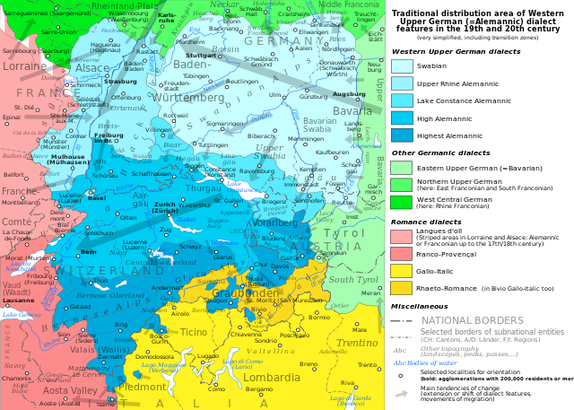
English: The traditional distribution area of the western Upper German (=Alemannic) dialects in the 19th and 20th century. Source: Mainly these articles in the German wikipedia:
plus the (younger) literature, which is mentioned there. This area, having been quite stable for at least some 300 years up to the 19th century, saw consecutively more or less strong changes by industrialisation, population growth, migrations and political developments. Deutsch: Das traditionelle Verbreitungsgebiet der westoberdeutschen (=alemannischen) Dialekte im 19. und 20. Jahrhundert. Grundlage: vor allem diese Artikel der deutschsprachigen Wikipedia:
sowie die dort jeweils genannte (jüngere) Literatur. Das bis ins 19. Jahrhundert für mindestens etwa 300 Jahre stabile Gebiet erfuhr nachfolgend durch Industrialisierung, Bevölkerungszuwächse und -bewegungen sowie politische Entwicklungen mehr oder weniger starke Änderungen. Français : Le secteur de distribution traditionnel des dialectes allemands supérieurs occidentaux (=alémannique) au 19e et 20e siècle. Source : Principalement ces articles dans le wikipedia allemand :
plus la littérature (plus jeune), qui est mentionnée là. Ce secteur, après avoir été stable jusqu'au 19e siècle pour au moins environ 300 années, scie consécutivement des changements plus ou moins forts par industrialisation, croissance démographique, migrations et développements politiques. |
| תאריך יצירה | (UTC) |
| מקור | |
| יוצר |
|
| גרסאות אחרות |
PNG:
PNG:
SVG:
SVG: SVG:
|


| זוהי תמונה מרוטשת, זאת אומרת שהתמונה שונתה בצורה דיגיטלית מהמקור. Modifications: English version. את התמונה המקורית ניתן לראות ב: Alemannic-Dialects-Map-German.svg. השינוי בוצע על ידי Testtube.
|
אני, בעל זכויות היוצרים על היצירה הזאת, מפרסם אותה בזאת תחת הרישיונות הבאים:
הקובץ הזה מתפרסם לפי תנאי רישיונות קריאייטיב קומונז ייחוס-שיתוף זהה 3.0 לא מותאם, 2.5 כללי, 2.0 כללי ו־1.0 כללי.
- הנכם רשאים:
- לשתף – להעתיק, להפיץ ולהעביר את העבודה
- לערבב בין עבודות – להתאים את העבודה
- תחת התנאים הבאים:
- ייחוס – יש לתת ייחוס הולם, לתת קישור לרישיון, ולציין אם נעשו שינויים. אפשר לעשות את זה בכל צורה סבירה, אבל לא בשום צורה שמשתמע ממנה שמעניק הרישיון תומך בך או בשימוש שלך.
- שיתוף זהה – אם תיצרו רמיקס, תשנו, או תבנו על החומר, חובה עליכם להפיץ את התרומות שלך לפי תנאי רישיון זהה או תואם למקור.

|
מוענקת בכך הרשות להעתיק, להפיץ או לשנות את המסמך הזה, לפי תנאי הרישיון לשימוש חופשי במסמכים של גנו, גרסה 1.2 או כל גרסה מאוחרת יותר שתפורסם על־ידי המוסד לתוכנה חופשית; ללא פרקים קבועים, ללא טקסט עטיפה קדמית וללא טקסט עטיפה אחורית. עותק של הרישיון כלול בפרק שכותרתו הרישיון לשימוש חופשי במסמכים של גנו. |
הנכם מוזמנים לבחור את הרישיון הרצוי בעיניכם.
יומן העלאה מקורי[עריכה]
This image is a derivative work of the following images:
- File:Alemannic-Dialects-Map-German.svg licensed with Cc-by-sa-3.0,2.5,2.0,1.0, GFDL
- 2010-08-10T18:15:19Z Testtube 1400x1000 (482884 Bytes) Bugfixes, additions, corrections.
- 2010-08-04T17:04:09Z Testtube 1400x1000 (448634 Bytes) Changed fonts to SVG fonts. Some other little corrections.
- 2010-08-02T21:59:37Z Testtube 1400x1000 (443758 Bytes) Bugfixes
- 2010-08-02T21:00:02Z Testtube 1400x1000 (454345 Bytes) Reverted to version as of 19:02, 2 August 2010. Bugfix unsuccessful.
- 2010-08-02T20:57:51Z Testtube 1400x1000 (443820 Bytes) Fehlerhafte Textdarstellung korrigiert
- 2010-08-02T19:02:57Z Testtube 1400x1000 (454345 Bytes) {{Information |Description={{{{en|The traditional distribution area of the western upper german (=alemannic) dialects about 1860. Source: Mainly these articles in the german wikipedia: "Alemanische Dialekte", "Grenzorte des a
Uploaded with derivativeFX
היסטוריית הקובץ
ניתן ללחוץ על תאריך/שעה כדי לראות את הקובץ כפי שנראה באותו זמן.
| תאריך/שעה | תמונה ממוזערת | ממדים | משתמש | הערה | |
|---|---|---|---|---|---|
| נוכחית | 11:08, 31 בינואר 2024 | | 1,000 × 1,400 (472 ק"ב) | Mahagaja (שיחה | תרומות) | a few more corrections |
| 16:08, 30 בינואר 2024 |  | 1,000 × 1,400 (472 ק"ב) | Mahagaja (שיחה | תרומות) | improved English | |
| 18:25, 6 במרץ 2017 |  | 1,000 × 1,400 (472 ק"ב) | Leandrod (שיחה | תרומות) | Orthography: oïl, provençal | |
| 16:59, 19 באוגוסט 2010 |  | 1,000 × 1,400 (472 ק"ב) | Testtube~commonswiki (שיחה | תרומות) | Bugfix. | |
| 20:11, 11 באוגוסט 2010 |  | 1,000 × 1,400 (471 ק"ב) | Testtube~commonswiki (שיחה | תרומות) | Bugfix | |
| 19:44, 11 באוגוסט 2010 |  | 1,000 × 1,400 (471 ק"ב) | Testtube~commonswiki (שיחה | תרומות) | Bugfix | |
| 15:14, 11 באוגוסט 2010 |  | 1,000 × 1,400 (471 ק"ב) | Testtube~commonswiki (שיחה | תרומות) | {{Information |Description={{en|1=The traditional distribution area of the western upper german (=alemannic) dialects in the 19th and 20th century. Source: Mainly these articles in the german wikipedia: * [http://de.wikipedia.org/wiki/Alemannische_Dialek |
אין באפשרותך לדרוס את הקובץ הזה.
שימוש בקובץ
הדפים הבאים משתמשים בקובץ הזה:
- User:Chumwa/OgreBot/Travel and communication maps/2017 March 1-10
- User:Chumwa/OgreBot/Travel and communication maps/2024 January 21-31
- File:AlemBeispielsatz Orte1 de.svg
- File:AlemByspylsatz Ort1.svg
- File:Alemannic-Dialects-Map-English.png
- File:Alemannic-Dialects-Map-English.svg
- File:Alemannic-Dialects-Map-French.png
- File:Alemannic-Dialects-Map-French.svg
- File:Alemannic-Dialects-Map-German.png
- File:Alemannic-Dialects-Map-German.svg
- File:Alemannic-Dialects-Map-Hungarian.png
- File:Alemannic-Dialects-Map-Hungarian.svg
- File:Alemannic language location map in 1950-de.svg
- File:Alemannic language location map in 1950-fr.svg
- File:Alemannic language location map in 1950 with countries-fr.svg
- File:Alemannisch-korrigiert.png
- File:Alemannisch.png
- File:Alemannisch blank.png
- File:Alemannisch hu.png
- File:Charte Alemannisch korrigiert2.svg
- File:Charte Alemannisch korrigiert 4.svg
- File:Charte Alemannisch korrigiert 5.svg
- Template:Alemannic-dialects-maps
שימוש גלובלי בקובץ
אתרי הוויקי השונים הבאים משתמשים בקובץ זה:
- שימוש באתר an.wikipedia.org
- שימוש באתר ar.wikipedia.org
- שימוש באתר en.wikipedia.org
- שימוש באתר en.wiktionary.org
- שימוש באתר he.wikipedia.org
- שימוש באתר id.wikipedia.org
- שימוש באתר it.wikipedia.org
- שימוש באתר lij.wikipedia.org
- שימוש באתר pt.wikipedia.org
- שימוש באתר simple.wikipedia.org
- שימוש באתר sq.wikipedia.org
- שימוש באתר sv.wikipedia.org
- שימוש באתר vi.wikipedia.org