File:Asie.svg
둘러보기로 이동
검색으로 이동

SVG 파일의 PNG 형식의 미리보기 크기: 788 × 600 픽셀. 다른 해상도: 316 × 240 픽셀 | 631 × 480 픽셀 | 1,009 × 768 픽셀 | 1,280 × 974 픽셀 | 2,560 × 1,948 픽셀 | 1,100 × 837 픽셀
원본 파일 (SVG 파일, 실제 크기 1,100 × 837 픽셀, 파일 크기: 567 KB)
캡션
설명
이 파일이 나타내는 바에 대한 한 줄 설명을 추가합니다
| 설명 |
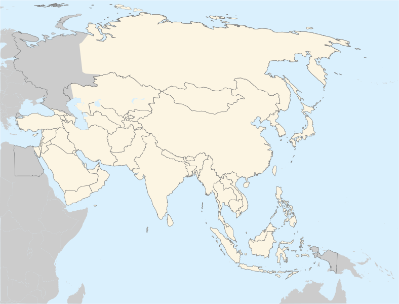
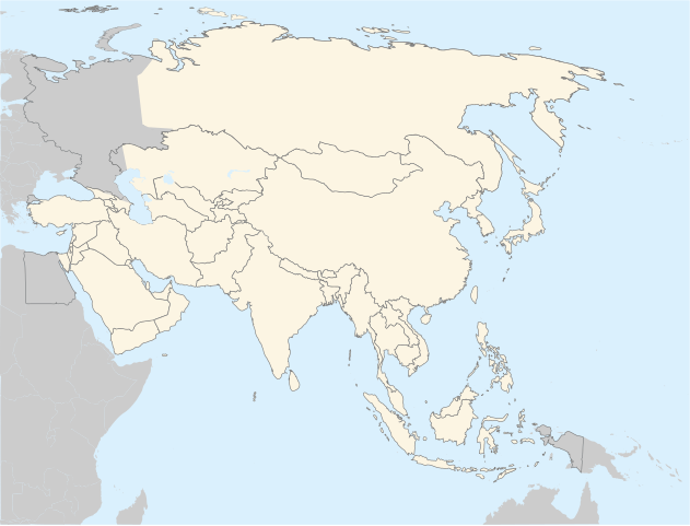
Français : Carte politique de l'Asie
English: Asia political map. The continental boundary to Europe follows the mainstream convention along the Urals, the Ural River, and the crest of the Greater Caucasus.
Português: Mapa politico da Ásia. |
||
| 날짜 | |||
| 출처 | http://en.wikipedia.org/wiki/Image:BlankMap-World5.svg | ||
| 저자 | historicair 20:31, 20 November 2006 (UTC) | ||
| 저작권 (이 파일을 인용하기) |
|
||
| 다른 버전 |
이 파일은 다음으로 파생됨: |
파일 역사
날짜/시간 링크를 클릭하면 해당 시간의 파일을 볼 수 있습니다.
| 날짜/시간 | 섬네일 | 크기 | 사용자 | 설명 | |
|---|---|---|---|---|---|
| 현재 | 2022년 9월 4일 (일) 18:27 | | 1,100 × 837 (567 KB) | Рагин1987 (토론 | 기여) | Correction |
| 2022년 8월 30일 (화) 20:07 |  | 2,560 × 1,948 (935 KB) | Рагин1987 (토론 | 기여) | More correct visualization of the dividing line on the territory of the Caucasus Range | |
| 2011년 4월 13일 (수) 02:37 |  | 1,100 × 837 (522 KB) | Gerge (토론 | 기여) | Reverted to version as of 06:06, 12 April 2011 | |
| 2011년 4월 12일 (화) 23:11 |  | 1,100 × 837 (522 KB) | Green, White and Gold (토론 | 기여) | Reverted to Dbachmann's version as of 06:52, 11 April 2011 | |
| 2011년 4월 12일 (화) 06:06 |  | 1,100 × 837 (522 KB) | Sigismun (토론 | 기여) | Reverted to version as of 00:55, 12 April 2011 | |
| 2011년 4월 12일 (화) 01:00 |  | 1,100 × 837 (522 KB) | Green, White and Gold (토론 | 기여) | Reverted to Dbachmann's version as of 06:52, 11 April 2011 | |
| 2011년 4월 12일 (화) 00:55 |  | 1,100 × 837 (522 KB) | Green, White and Gold (토론 | 기여) | Reverted to Dbachmann's version as of 06:52, 11 April 2011 | |
| 2011년 4월 11일 (월) 14:16 |  | 788 × 600 (197 KB) | ComtesseDeMingrelie (토론 | 기여) | Reverted to version as of 14:45, 5 April 2011 | |
| 2011년 4월 11일 (월) 06:52 |  | 1,100 × 837 (522 KB) | Dbachmann (토론 | 기여) | Reverted to version as of 20:44, 4 April 2011 | |
| 2011년 4월 5일 (화) 14:45 |  | 788 × 600 (197 KB) | ComtesseDeMingrelie (토론 | 기여) | Reverted to version as of 01:05, 5 April 2011 |
이 파일을 덮어쓸 수 없습니다.
이 파일을 사용하는 문서
다음 문서 26개가 이 파일을 사용하고 있습니다:
- Asia
- Commons:Graphic Lab/Map workshop/Archive/2018
- File:Belitung ship routes.svg
- File:China-Manchukuo-map-2.svg
- File:China-Manchukuo-map-fr.png
- File:Cyclemys atripons distribution map.png
- File:Cyclemys enigmatica distribution map.png
- File:Cyclemys fusca distribution map.png
- File:Cyclemys pulchristiata distribution map.png
- File:Die Chinesische Mauer - Karte.jpg
- File:Die Chinesische Mauer - blank-01.jpg
- File:Distribution Map Neofelis nebulosa.svg
- File:Distribution Map Neofelis nebulosa 1994.svg
- File:Distribution Map Neofelis nebulosa IUCN.svg
- File:Distribution Map Neofelis nebulosa Summit.svg
- File:Gemeiner Kurznasenflughund 2016.png
- File:Image-Die Chinesische Mauer - Karte (mit einfachen Linien).jpg
- File:Map of ASEAN member states.svg
- File:Map of the Great Wall of China.jpg
- File:Oriental field week world map.svg
- File:Qualifs AFC 1956.svg
- File:Qualifs AFC 1960.svg
- File:Qualifs AFC 1964.svg
- File:Qualifs AFC 1968.svg
- File:Qualifs AFC 1972.svg
- Template:Asia and Sea
.jpg)
이 파일을 사용하고 있는 모든 위키의 문서 목록
다음 위키에서 이 파일을 사용하고 있습니다:
- ar.wikipedia.org에서 이 파일을 사용하고 있는 문서 목록
- az.wikipedia.org에서 이 파일을 사용하고 있는 문서 목록
- bg.wikipedia.org에서 이 파일을 사용하고 있는 문서 목록
- bh.wikipedia.org에서 이 파일을 사용하고 있는 문서 목록
- ca.wikipedia.org에서 이 파일을 사용하고 있는 문서 목록
- cs.wikipedia.org에서 이 파일을 사용하고 있는 문서 목록
- el.wikipedia.org에서 이 파일을 사용하고 있는 문서 목록
- en.wikipedia.org에서 이 파일을 사용하고 있는 문서 목록
- fa.wikipedia.org에서 이 파일을 사용하고 있는 문서 목록
- gl.wikipedia.org에서 이 파일을 사용하고 있는 문서 목록
- hi.wikipedia.org에서 이 파일을 사용하고 있는 문서 목록
- hr.wikipedia.org에서 이 파일을 사용하고 있는 문서 목록
- incubator.wikimedia.org에서 이 파일을 사용하고 있는 문서 목록
- it.wikipedia.org에서 이 파일을 사용하고 있는 문서 목록
이 파일의 더 많은 사용 내역을 봅니다.