File:Australia Capital Territory location map.svg
קפיצה לניווט
קפיצה לחיפוש

גודל התצוגה המקדימה הזאת מסוג PNG של קובץ ה־SVG הזה: 414 × 600 פיקסלים. רזולוציות אחרות: 166 × 240 פיקסלים | 331 × 480 פיקסלים | 530 × 768 פיקסלים | 707 × 1,024 פיקסלים | 1,414 × 2,048 פיקסלים | 477 × 691 פיקסלים.
לקובץ המקורי (קובץ SVG, הגודל המקורי: 477 × 691 פיקסלים, גודל הקובץ: 272 ק"ב)
כיתובים
כיתובים
נא להוסיף משפט שמסביר מה הקובץ מייצג
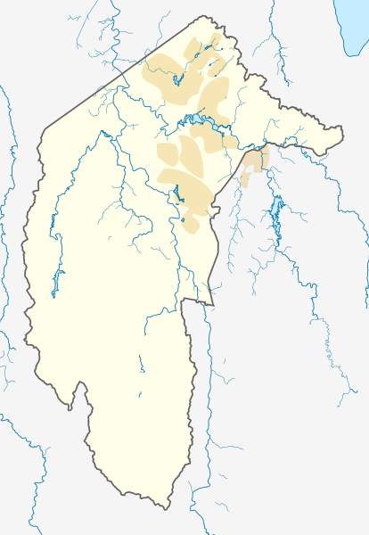
Location map of the Australian Capital Territory.
| תיאור |
Deutsch: Positionskarte des Australian Capital Territory, Australien.
Mercator-Projektion. Geographische Begrenzungen der Karte:
English: Location map of the Australian Capital Territory, Australia.
Mercator projection. Geographic limits of the map:
|
|||
| תאריך יצירה |
Original Version: 2012-12-19 |
|||
| מקור | נוצר על־ידי מעלה היצירה, using OpenStreetMap data. Urban areas redrawn using OpenStreetMap data current at date above. | |||
| יוצר |
Original Version: Carport |
|||
| אישורים והיתרים (שימוש חוזר בקובץ זה) |
הקובץ הזה מתפרסם לפי תנאי רישיון קריאייטיב קומונז ייחוס-שיתוף זהה 3.0 לא מותאם.
|
היסטוריית הקובץ
ניתן ללחוץ על תאריך/שעה כדי לראות את הקובץ כפי שנראה באותו זמן.
| תאריך/שעה | תמונה ממוזערת | ממדים | משתמש | הערה | |
|---|---|---|---|---|---|
| נוכחית | 09:39, 2 ביוני 2013 | | 691 × 477 (272 ק"ב) | Nbound (שיחה | תרומות) | Back to more neutral colours |
| 09:31, 2 ביוני 2013 |  | 691 × 477 (272 ק"ב) | Nbound (שיחה | תרומות) | Redraw urban areas | |
| 20:57, 19 בדצמבר 2012 |  | 691 × 477 (274 ק"ב) | Carport (שיחה | תרומות) | {{Information |Description={{de|1=Positionskarte des {{w|Australian Capital Territory|3=de}}, {{w|Australien|3=de}}. Mercator-Projektion. Geographische Begrenzungen der Karte: * N: 35.1° S * S: 35.96° S * W: 148.72° O * O: 149.45° O }} [[Category... |
אין באפשרותך לדרוס את הקובץ הזה.
שימוש בקובץ
אין דפים המשתמשים בקובץ זה.
שימוש גלובלי בקובץ
אתרי הוויקי השונים הבאים משתמשים בקובץ זה:
- שימוש באתר af.wikipedia.org
- שימוש באתר bg.wikipedia.org
- שימוש באתר bn.wikipedia.org
- שימוש באתר ceb.wikipedia.org
- שימוש באתר de.wikipedia.org
- Canberra
- Black Mountain Tower
- Flughafen Canberra
- Yarralumla
- Kaleen (Stadtteil)
- Mount Majura
- Mount Taylor (Australien)
- Mount Ainslie
- Black Mountain (Australian Capital Territory)
- Lake Burley Griffin
- Capital Hill
- Lake Ginninderra
- Lake Tuggeranong
- Canberra Stadium
- Mount Stromlo
- National Zoo and Aquarium
- Manuka Oval
- Giralang
- Vorlage:Infobox Stausee
- Vorlage:Infobox Stausee/Doku
- Wikipedia:Kartenwerkstatt/Positionskarten/Australien und Ozeanien
- Vorlage:Infobox Ort in Australien
- Vorlage:Infobox Ort in Australien/Doku
- Vorlage:Positionskarte Australien Capital Territory
- Benutzer:Rr2000/Vorlagentest Ort in Australien
- Bimberi Peak
- Mount Franklin (Australian Capital Territory)
- Strathnairn
- שימוש באתר en.wikipedia.org
- Namadgi National Park
- Tidbinbilla Nature Reserve
- Fyshwick, Australian Capital Territory
- Mount Ainslie
- Lake Burley Griffin
- Molonglo River
- Acton, Australian Capital Territory
- Weston, Australian Capital Territory
- Civic, Australian Capital Territory
- Yarralumla, Australian Capital Territory
- Deakin, Australian Capital Territory
- Black Mountain (Australian Capital Territory)
- Campbell, Australian Capital Territory
- Reid, Australian Capital Territory
- Canberra Airport
- Braddon, Australian Capital Territory
צפייה בשימושים גלובליים נוספים של קובץ זה.