File:Austria locator map (1000).svg
קפיצה לניווט
קפיצה לחיפוש

גודל התצוגה המקדימה הזאת מסוג PNG של קובץ ה־SVG הזה: 619 × 599 פיקסלים. רזולוציות אחרות: 248 × 240 פיקסלים | 496 × 480 פיקסלים | 793 × 768 פיקסלים | 1,058 × 1,024 פיקסלים | 2,116 × 2,048 פיקסלים | 1,875 × 1,815 פיקסלים.
לקובץ המקורי (קובץ SVG, הגודל המקורי: 1,875 × 1,815 פיקסלים, גודל הקובץ: 5.74 מ"ב)
כיתובים
כיתובים
נא להוסיף משפט שמסביר מה הקובץ מייצג

תקציר[עריכה]
. Inkscape עם נוצרה ה תמונה
| תיאור |
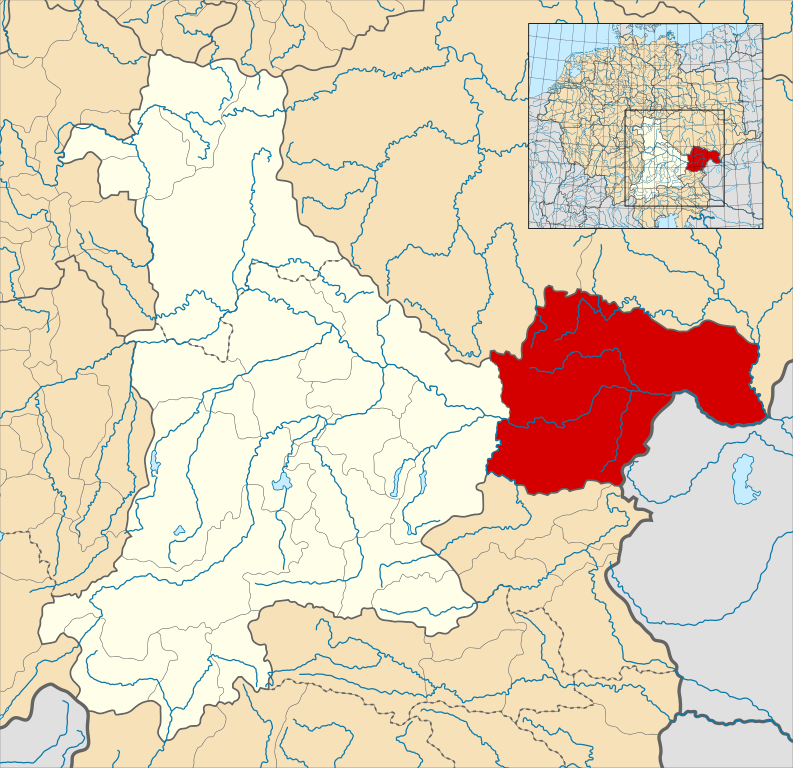
English: A map of the Margraviate of Austria (German: Markgrafschaft Österreich; Old High German: Ostarrîchi) within the Duchy of Bavaria around the year 1000.
The map is derived from a vectorised version of one found in Professor G. Droysens Allgemeiner Historischer Handatlas, which was published in 1886 by R. Andrée Plate, and is now in the public domain. Note that while it uses the same scheme as standard location/locator maps, this map technically does not conform to the standard, as it is not in equirectangular projection. Therefore grid lines for latitude and longitude are also included on the sub-map. |
| תאריך יצירה | |
| מקור |
File: own work Data: File:Droysens-22-23.jpg |
| יוצר | Alphathon /ˈæɫfə.θɒn/ (talk) |
| גרסאות אחרות |
|
.svg)
.svg)

.svg)
.svg)
.svg&action=edit§ion=1)
רישיון[עריכה]
.svg&action=edit§ion=2)
הקובץ הזה מתפרסם לפי תנאי רישיון קריאייטיב קומונז ייחוס-שיתוף זהה 4.0 בין־לאומי.
- הנכם רשאים:
- לשתף – להעתיק, להפיץ ולהעביר את העבודה
- לערבב בין עבודות – להתאים את העבודה
- תחת התנאים הבאים:
- ייחוס – יש לתת ייחוס הולם, לתת קישור לרישיון, ולציין אם נעשו שינויים. אפשר לעשות את זה בכל צורה סבירה, אבל לא בשום צורה שמשתמע ממנה שמעניק הרישיון תומך בך או בשימוש שלך.
- שיתוף זהה – אם תיצרו רמיקס, תשנו, או תבנו על החומר, חובה עליכם להפיץ את התרומות שלך לפי תנאי רישיון זהה או תואם למקור.
היסטוריית הקובץ
ניתן ללחוץ על תאריך/שעה כדי לראות את הקובץ כפי שנראה באותו זמן.
| תאריך/שעה | תמונה ממוזערת | ממדים | משתמש | הערה | |
|---|---|---|---|---|---|
| נוכחית | 16:32, 18 במאי 2016 | | 1,815 × 1,875 (5.74 מ"ב) | Alphathon (שיחה | תרומות) | == {{int:filedesc}} == {{Inkscape}} {{Information |Description={{en|A map of the en:Margraviate of Austria (German: ''Markgrafschaft Österreich''; Old High German: ''Ostarrîchi'') within the Duchy of Bavaria around the year 1000. The map is... |
אין באפשרותך לדרוס את הקובץ הזה.
שימוש בקובץ
הדפים הבאים משתמשים בקובץ הזה:
שימוש גלובלי בקובץ
אתרי הוויקי השונים הבאים משתמשים בקובץ זה:
- שימוש באתר arz.wikipedia.org
- שימוש באתר ast.wikipedia.org
- שימוש באתר cs.wikipedia.org
- שימוש באתר en.wikipedia.org
- שימוש באתר eo.wikipedia.org
- שימוש באתר es.wikipedia.org
- שימוש באתר fi.wikipedia.org
- שימוש באתר fr.wikipedia.org
- שימוש באתר he.wikipedia.org
- שימוש באתר hr.wikipedia.org
- שימוש באתר hy.wikipedia.org
- שימוש באתר id.wikipedia.org
- שימוש באתר it.wikipedia.org
- שימוש באתר ja.wikipedia.org
- שימוש באתר ko.wikipedia.org
- שימוש באתר pl.wikipedia.org
- שימוש באתר pt.wikipedia.org
- שימוש באתר ru.wikipedia.org
- שימוש באתר sl.wikipedia.org
- שימוש באתר uk.wikipedia.org
- שימוש באתר vi.wikipedia.org
- שימוש באתר www.wikidata.org
- שימוש באתר zh.wikipedia.org
.svg&oldid=808267761)