File:BahnTower, Potsdamer Platz, Berin-1750.jpg

לקובץ המקורי (2,953 × 4,430 פיקסלים, גודל הקובץ: 9.84 מ"ב, סוג MIME: image/jpeg)
כיתובים
כיתובים
תקציר
אובייקט
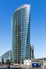
| הלמוט יאן: BahnTower
|
||||||||||||||||||||||||||
|---|---|---|---|---|---|---|---|---|---|---|---|---|---|---|---|---|---|---|---|---|---|---|---|---|---|---|
| אדריכל |
|
 | ||||||||||||||||||||||||
| כותרת |
BahnTower |
|||||||||||||||||||||||||
| סוג אובייקט |
גורד שחקים / בניין משרדים |
|||||||||||||||||||||||||
| תיאור |
Deutsch: BahnTower, Potsdamer Platz, Berin |
|||||||||||||||||||||||||
| תאריך יצירה | 13 במאי 2023 10:02:15.00 | |||||||||||||||||||||||||
| ממדים |
גובה: 103 מ' |
|||||||||||||||||||||||||
| אוסף | ||||||||||||||||||||||||||
| מיקום האובייקט |
|
|||||||||||||||||||||||||
| סימוכין |
https://3dwarehouse.sketchup.com/model.html?id=27d673e4d4137c2d956d23d59a179d02&prevstart=0 |
|||||||||||||||||||||||||
| גרסאות אחרות |
|
|||||||||||||||||||||||||


תצלום
| תיאור |
English: BahnTower at Potsdamer Platz in Berlin |
|||||||||||||||||
| תאריך יצירה |
|
|||||||||||||||||
| מקור | נוצר על־ידי מעלה היצירה | |||||||||||||||||
| יוצר |
|
|||||||||||||||||
| ייחוס (required by the license) | © Raimond Spekking / | |||||||||||||||||

| מיקום המצלמה | | תמונה זו ותמונות נוספות במיקום: OpenStreetMap |
|---|
I have published this image as author under the Creative-Commons-Licence CC BY-SA 4.0.. This means that free online usage outside of Wikimedia projects under the following terms of licence is possible:
- The image is credited with "© Raimond Spekking / CC BY-SA 4.0 (via Wikimedia Commons)"
For all other kind of usages (books, journales, flyers, etc.) click on the following button. You will get all information needed.
I would be happy to receive a specimen copy or the URL of the website where the image is used.
Please write an email to raimond.spekking@gmail.com (GPG encrypted emails are welcome: Key-ID: 0xB12BE7A6), if you
- need the image in a higher resolution
- need my postal address for sending a specimen copy
- have further questions to the terms of licence
רישיון
- הנכם רשאים:
- לשתף – להעתיק, להפיץ ולהעביר את העבודה
- לערבב בין עבודות – להתאים את העבודה
- תחת התנאים הבאים:
- ייחוס – יש לתת ייחוס הולם, לתת קישור לרישיון, ולציין אם נעשו שינויים. אפשר לעשות את זה בכל צורה סבירה, אבל לא בשום צורה שמשתמע ממנה שמעניק הרישיון תומך בך או בשימוש שלך.
- שיתוף זהה – אם תיצרו רמיקס, תשנו, או תבנו על החומר, חובה עליכם להפיץ את התרומות שלך לפי תנאי רישיון זהה או תואם למקור.
היסטוריית הקובץ
ניתן ללחוץ על תאריך/שעה כדי לראות את הקובץ כפי שנראה באותו זמן.
| תאריך/שעה | תמונה ממוזערת | ממדים | משתמש | הערה | |
|---|---|---|---|---|---|
| נוכחית | 16:30, 21 במאי 2023 | | 4,430 × 2,953 (9.84 מ"ב) | Raymond (שיחה | תרומות) | Uploaded with LrMediaWiki 1.3.0, LR 6.14 Win |
אין באפשרותך לדרוס את הקובץ הזה.
שימוש בקובץ
הדפים הבאים משתמשים בקובץ הזה:
- BahnTower
- Deutsche Bahn
- Potsdamer Platz
- Sony Center
- User:Nordlicht8/Rail Germany/2023 May 21-31
- File:BahnTower, Potsdamer Platz, Berin-1750.jpg
- File:Potsdamer platz 01.jpg
- Category:BahnTower
- Category:Deutsche Bahn
- Category:People associated with Deutsche Bahn
- Category:Rail vehicles of Deutsche Bahn
- Category:Views from BahnTower
שימוש גלובלי בקובץ
אתרי הוויקי השונים הבאים משתמשים בקובץ זה:
- שימוש באתר af.wikipedia.org
- שימוש באתר ar.wikipedia.org
- שימוש באתר arz.wikipedia.org
- שימוש באתר be.wikipedia.org
- שימוש באתר bg.wikipedia.org
- שימוש באתר ca.wikipedia.org
- שימוש באתר cs.wikipedia.org
- שימוש באתר da.wikipedia.org
- שימוש באתר de.wikipedia.org
- שימוש באתר el.wikipedia.org
- שימוש באתר en.wikipedia.org
- שימוש באתר eo.wikipedia.org
- שימוש באתר es.wikipedia.org
- שימוש באתר eu.wikipedia.org
- שימוש באתר fi.wikipedia.org
- שימוש באתר fr.wikipedia.org
- שימוש באתר gl.wikipedia.org
- שימוש באתר he.wikipedia.org
- שימוש באתר hu.wikipedia.org
- שימוש באתר it.wikipedia.org
- שימוש באתר nl.wikipedia.org
- שימוש באתר no.wikipedia.org
- שימוש באתר pl.wikipedia.org
- שימוש באתר pms.wikipedia.org
- שימוש באתר ro.wikipedia.org
- שימוש באתר ru.wikipedia.org
- שימוש באתר sk.wikipedia.org
- שימוש באתר sv.wikipedia.org
- שימוש באתר tk.wikipedia.org
- שימוש באתר tr.wikipedia.org
- שימוש באתר uk.wikipedia.org
- שימוש באתר www.wikidata.org