File:Battle of Savo Island map - disposition of forces.png
קפיצה לניווט
קפיצה לחיפוש
גודל התצוגה המקדימה הזאת: 800 × 525 פיקסלים. רזולוציות אחרות: 320 × 210 פיקסלים | 640 × 420 פיקסלים | 1,024 × 672 פיקסלים | 1,357 × 890 פיקסלים.
לקובץ המקורי (1,357 × 890 פיקסלים, גודל הקובץ: 331 ק"ב, סוג MIME: image/png)
כיתובים
כיתובים
נא להוסיף משפט שמסביר מה הקובץ מייצג
תקציר[עריכה]
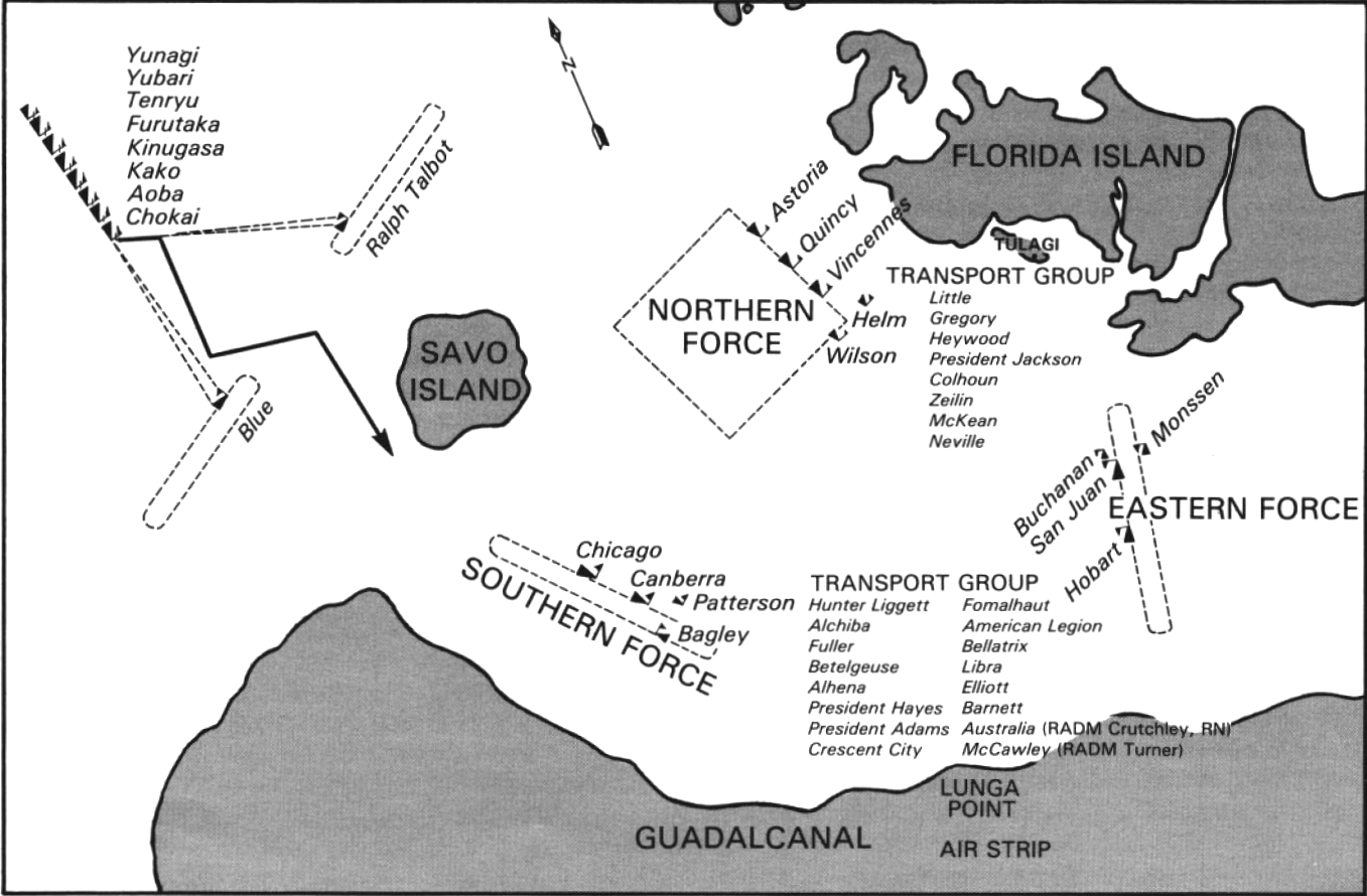
| תיאור | Map showing the disposition of the Imperial Japanese and U.S. forces at the beginning of the Battle of Savo Island, circa 0100-0120 hrs on 9 August 1942. |
| תאריך יצירה | |
| מקור | U.S. Navy All Hands magazine November 1980, p. 46. |
| יוצר | U.S. Navy |
| אישורים והיתרים (שימוש חוזר בקובץ זה) |
"All photographs published in ALL HANDS are official Department of Defense photographs unless otherwise designated." |
רישיון[עריכה]
This image is a work of a U.S. military or Department of Defense employee, taken or made as part of that person's official duties. As a work of the U.S. federal government, the image is in the public domain in the United States.
|
 |
היסטוריית הקובץ
ניתן ללחוץ על תאריך/שעה כדי לראות את הקובץ כפי שנראה באותו זמן.
| תאריך/שעה | תמונה ממוזערת | ממדים | משתמש | הערה | |
|---|---|---|---|---|---|
| נוכחית | 21:53, 24 בנובמבר 2014 | | 890 × 1,357 (331 ק"ב) | Cobatfor (שיחה | תרומות) | == {{int:filedesc}} == {{Information |Description=Map showing the disposition of the Imperial Japanese and U.S. forces at the beginning of the Battle of Savo Island, circa 0100-0120 hrs on 9 August 1942. |Source=[http://www.navy.mil/ah_online/departmen... |
אין באפשרותך לדרוס את הקובץ הזה.
שימוש בקובץ
הדף הבא משתמש בקובץ הזה:
שימוש גלובלי בקובץ
אתרי הוויקי השונים הבאים משתמשים בקובץ זה:
- שימוש באתר azb.wikipedia.org
- שימוש באתר en.wikipedia.org
- שימוש באתר he.wikipedia.org
- שימוש באתר it.wikipedia.org
- שימוש באתר pl.wikipedia.org