File:Borders of the Historical Habsburgian Lands in the Republic of Slovenia.png
둘러보기로 이동
검색으로 이동

미리 보기 크기: 800 × 555 픽셀 다른 해상도: 320 × 222 픽셀 | 640 × 444 픽셀 | 919 × 637 픽셀
원본 파일 (919 × 637 픽셀, 파일 크기: 49 KB, MIME 종류: image/png)
캡션
설명
이 파일이 나타내는 바에 대한 한 줄 설명을 추가합니다

파일 설명[편집]
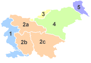
No. |
English |
||
| 1 | Littoral * | Primorska | Küstenland |
| 2 | Carniola | Kranjska | Krain |
| 2a | Upper Carniola | Gorenjska | Oberkrain |
| 2b | Inner Carniola | Notranjska | Innerkrain |
| 2c | Lower Carniola and White Carniola |
Dolenjska in Bela krajina |
Unterkrain und Weißkrain |
| 3 | Carinthia | Koroška | Kärnten |
| 4 | Styria | (Spodnja) Štajerska |
Untersteiermark |
| 5 | Prekmurje ** | Übermurgebiet ** | |
*Littoral used to be part of the historical Austrian Littoral.
**Prekmurje was not part of the historical Austrian crownland, but belonged to the Hungarian crown.

|
이 그림은 벡터 그래픽 버전(SVG)이 있습니다. 래스터 그림 대신 벡터 그래픽 그림을 사용해야 합니다.
File:Borders of the Historical Habsburgian Lands in the Republic of Slovenia.png → File:Borders of the Historical Habsburgian Lands in the Republic of Slovenia.svg
|
 |
라이선스[편집]

|
GNU 자유 문서 사용 허가서 1.2판 또는 자유 소프트웨어 재단에서 발행한 이후 판의 규정에 따라 본 문서를 복제하거나 개작 및 배포할 수 있습니다. 본 문서에는 변경 불가 부분이 없으며, 앞 표지 구절과 뒷 표지 구절도 없습니다. 본 사용 허가서의 전체 내용은 GNU 자유 문서 사용 허가서 부분에 포함되어 있습니다. |
| 이 파일은 크리에이티브 커먼즈 저작자표시-동일조건변경허락 3.0 Unported 라이선스로 배포됩니다. | ||
| ||
| 이 라이선스 틀은 GFDL 라이선스 변경의 일부로 이 파일에 추가되었습니다. |
파일 역사
날짜/시간 링크를 클릭하면 해당 시간의 파일을 볼 수 있습니다.
| 날짜/시간 | 섬네일 | 크기 | 사용자 | 설명 | |
|---|---|---|---|---|---|
| 현재 | 2012년 12월 18일 (화) 15:28 | | 919 × 637 (49 KB) | DancingPhilosopher (토론 | 기여) | color |
| 2012년 12월 18일 (화) 15:24 |  | 919 × 637 (49 KB) | DancingPhilosopher (토론 | 기여) | color | |
| 2012년 12월 17일 (월) 13:41 |  | 915 × 608 (46 KB) | DancingPhilosopher (토론 | 기여) | Corrected boundaries | |
| 2005년 7월 19일 (화) 22:22 |  | 400 × 289 (30 KB) | Besednjak~commonswiki (토론 | 기여) | Austrian Crownlands in todays Slovenia. 1: Primorska/Küstenland, 2: Kranjsko/Krain (Carniola), 2a: Gorenjska/Oberkrain (Upper Carniola), 2b: Notranjska/Innerkrain (Inner Carniola), 2c: Dolenjska/Unterkrain (Lower Carniola), 3: Koroška/Kärnten (Carinthi |
이 파일을 덮어쓸 수 없습니다.
이 파일을 사용하는 문서
다음 문서 1개가 이 파일을 사용하고 있습니다:
- File:Kronlander Slowenien.png (파일 넘겨주기)
이 파일을 사용하고 있는 모든 위키의 문서 목록
다음 위키에서 이 파일을 사용하고 있습니다:
- an.wikipedia.org에서 이 파일을 사용하고 있는 문서 목록
- ar.wikipedia.org에서 이 파일을 사용하고 있는 문서 목록
- ast.wikipedia.org에서 이 파일을 사용하고 있는 문서 목록
- be.wikipedia.org에서 이 파일을 사용하고 있는 문서 목록
- br.wikipedia.org에서 이 파일을 사용하고 있는 문서 목록
- ca.wikipedia.org에서 이 파일을 사용하고 있는 문서 목록
- cs.wikipedia.org에서 이 파일을 사용하고 있는 문서 목록
- cy.wikipedia.org에서 이 파일을 사용하고 있는 문서 목록
- en.wikipedia.org에서 이 파일을 사용하고 있는 문서 목록
- et.wikipedia.org에서 이 파일을 사용하고 있는 문서 목록
- eu.wikipedia.org에서 이 파일을 사용하고 있는 문서 목록
- fi.wikipedia.org에서 이 파일을 사용하고 있는 문서 목록
- fr.wikipedia.org에서 이 파일을 사용하고 있는 문서 목록
이 파일의 더 많은 사용 내역을 봅니다.