File:Budapest Székesföváros Térképe 01 (FL35076826 2552118).jpg

לקובץ המקורי (12,223 × 17,783 פיקסלים, גודל הקובץ: 276.2 מ"ב, סוג MIME: image/jpeg)
כיתובים
כיתובים
תקציר
[עריכה]| Budapest Székesföváros Térképe
( |
||||||||||||||||||||||||
|---|---|---|---|---|---|---|---|---|---|---|---|---|---|---|---|---|---|---|---|---|---|---|---|---|
| כותרת |
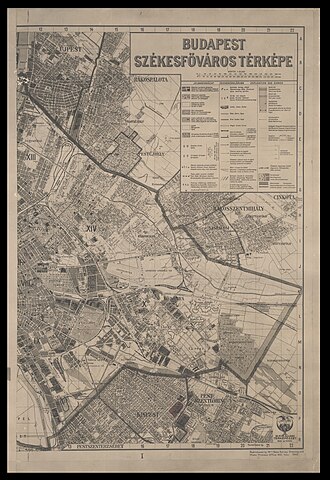
Budapest Székesföváros Térképe |
|||||||||||||||||||||||
| תיאור |
Budapest Székesföváros Térképe. |
|||||||||||||||||||||||
| שפה | הונגרית | |||||||||||||||||||||||
| תאריך הוצאה לאור | 1942 | |||||||||||||||||||||||
| טכניקה | 1 map on 2 sheets ; | |||||||||||||||||||||||
| ממדים | גובה: 74 ס"מ; רוחב: 51 ס"מ each sheet | |||||||||||||||||||||||
| אוסף |
|
|||||||||||||||||||||||
| מיקום נוכחי |
|
|||||||||||||||||||||||
| הערות | ||||||||||||||||||||||||
| קנה מידה | 1:25,000 cm | |||||||||||||||||||||||
| IE PID | IE35076824 | |||||||||||||||||||||||
| רוזטה שם קובץ | FL35076826 | |||||||||||||||||||||||
| מזהה רשומה בספרייה הלאומית (P3959) | 990025521180205171 | |||||||||||||||||||||||
| חיפוש בקטלוג מרחב | הונגרית | |||||||||||||||||||||||
| מקור/צלם |
|
|||||||||||||||||||||||
| גרסאות אחרות | ||||||||||||||||||||||||
| Jpg / Tif version |
|
|||||||||||||||||||||||

.jpg)

.jpg&action=edit§ion=1)
רישיון
[עריכה].jpg&action=edit§ion=2)
| This work is not covered by copyright.
This work was first published in Hungary in 1943 or before, and the identity of the author cannot be determined. According to the Hungarian copyright act of 1999 31. § (3): In the event the person of the author is unknown, the term of protection shall be seventy years and shall be counted from the first day of the year following the first disclosure of the work. For an explanation of the PD status in the US, see the template description page. Important: "the author is unknown" is NOT the same as "I don't know who the author is". You have to provide a reason why you think no one else can know it; otherwise the image shall be deleted. This work is in the public domain in the United States because it meets three requirements:
|
היסטוריית הקובץ
ניתן ללחוץ על תאריך/שעה כדי לראות את הקובץ כפי שנראה באותו זמן.
| תאריך/שעה | תמונה ממוזערת | ממדים | משתמש | הערה | |
|---|---|---|---|---|---|
| נוכחית | 00:16, 28 ביולי 2023 | | 17,783 × 12,223 (276.2 מ"ב) | Geagea (שיחה | תרומות) | c:User:Rillke/bigChunkedUpload.js: =={{int:filedesc}}== {{Artwork |artist = |author = |title = Budapest Székesföváros Térképe |description = Budapest Székesföváros Térképe. |language = {{Label|1=Q9067}} |date = |publication date = 1942 |medium = 1 map on 2 sheets ; |dimensions = {{size|cm|74|51}} each sheet |institution = {{Institution:Eran Laor Cartographic Collection}} |department = {{Institution:National Library of Israel}} |place of publication = |object history =... |
אין באפשרותך לדרוס את הקובץ הזה.
שימוש בקובץ
הדף הבא משתמש בקובץ הזה:
.jpg&oldid=836553865)