File:Cairo Tramways 01-map (FL50290394 4048653).jpg
![File:Cairo Tramways 01-map (FL50290394 4048653).jpg](https://upload.wikimedia.org/wikipedia/commons/thumb/8/89/Cairo_Tramways_01-map_%28FL50290394_4048653%29.jpg/800px-Cairo_Tramways_01-map_%28FL50290394_4048653%29.jpg?20230902130315)
לקובץ המקורי (6,642 × 4,870 פיקסלים, גודל הקובץ: 42.16 מ"ב, סוג MIME: image/jpeg)
כיתובים
כיתובים
תקציר
[עריכה]Cairo Tramways
(![]() ![]() ![]() |
||||||||||||||||||||||||
---|---|---|---|---|---|---|---|---|---|---|---|---|---|---|---|---|---|---|---|---|---|---|---|---|
כותרת |
Cairo Tramways |
|||||||||||||||||||||||
מפרסם |
publisher not identified |
|||||||||||||||||||||||
תיאור |
Cairo Tramways.. |
|||||||||||||||||||||||
שפה | אנגלית | |||||||||||||||||||||||
תאריך הוצאה לאור | 1942 ייתכן | |||||||||||||||||||||||
טכניקה | 1 map : color ; | |||||||||||||||||||||||
ממדים |
גובה: 16 ס"מ; רוחב: 24 ס"מ dimensions QS:P2048,16U174728 dimensions QS:P2049,24U174728 |
|||||||||||||||||||||||
אוסף |
institution QS:P195,Q111677119 |
|||||||||||||||||||||||
מיקום נוכחי |
institution QS:P195,Q188915 |
|||||||||||||||||||||||
מיקום הוצאה | unknown | |||||||||||||||||||||||
חיפוש בקטלוג מרחב InfoField | unknown | |||||||||||||||||||||||
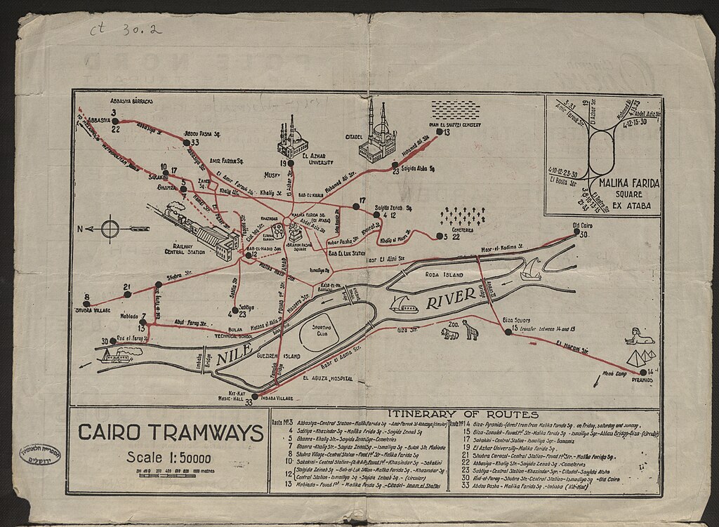
הערות | On verso commercial information and advertisments.; Pictorial map.; Inset map: Malika Farida square region.; Includes itinerary of routes. | |||||||||||||||||||||||
קנה מידה InfoField | 1:50,000 cm | |||||||||||||||||||||||
IE PID InfoField | IE50290392 | |||||||||||||||||||||||
רוזטה שם קובץ InfoField | FL50290394 | |||||||||||||||||||||||
מזהה רשומה בספרייה הלאומית (P3959) InfoField | 990040486530205171 | |||||||||||||||||||||||
חיפוש בקטלוג מרחב InfoField | אנגלית | |||||||||||||||||||||||
חיפוש בקטלוג מרחב InfoField | publisher not identified | |||||||||||||||||||||||
מקור/צלם |
|
|||||||||||||||||||||||
גרסאות אחרות | ||||||||||||||||||||||||
Jpg / Tif version InfoField |
|
![](https://upload.wikimedia.org/wikipedia/commons/thumb/e/e6/Nova_totius_terrarum_orbis_geographica_ac_hydrographica_tabula_%28990027185480205171%29_%28cropped%29.jpg/1240px-Nova_totius_terrarum_orbis_geographica_ac_hydrographica_tabula_%28990027185480205171%29_%28cropped%29.jpg)
רישיון
[עריכה]Public domainPublic domainfalsefalse |
![]() |
This UK artistic or literary work, of which the author is unknown and cannot be ascertained by reasonable enquiry, is in the public domain because it is one of the following:
|
![]() |
היסטוריית הקובץ
ניתן ללחוץ על תאריך/שעה כדי לראות את הקובץ כפי שנראה באותו זמן.
תאריך/שעה | תמונה ממוזערת | ממדים | משתמש | הערה | |
---|---|---|---|---|---|
נוכחית | 13:03, 2 בספטמבר 2023 | ![]() | 4,870 × 6,642 (42.16 מ"ב) | Geagea (שיחה | תרומות) | pattypan 22.03 |
אין באפשרותך לדרוס את הקובץ הזה.
שימוש בקובץ
הדף הבא משתמש בקובץ הזה:
מטא־נתונים
קובץ זה מכיל מידע נוסף, שכנראה הגיע ממצלמה דיגיטלית או מסורק שבהם הקובץ נוצר או עבר דיגיטציה.
אם הקובץ שונה ממצבו הראשוני, כמה מהנתונים להלן עלולים שלא לשקף באופן מלא את הקובץ הנוכחי.
תוכנה בשימוש | [[w:[global]dpi_mode= flexibledpi=600scanmode=waitcolormode=truecolordocmode=4docheight = 0wa_x = 1wa_y = 1serial=BE3-SGS-R2-0019999d6cd0FirmwareVersion=5.30e[autofocus]focus_x = -1000focus_y = 500focus_w = 2500[scan]autofocus=ondescreening=0cms=offspeed=1bright=109contr=109gamma=14gain_r=0gain_g=0gain_b=0aexp_black=10aexp =offdocsize=usersplitting=offsplitting_startpage=leftuser_x=-86user_w=11755user_y=178user_h=16602user_unit=milstarttimeout=1sharpen=2ies=off[preview]preview_scale=4preview_jpeg_quality=40[image]jpeg_quality=75fileformat=tiffmirror=offdeskew=0rotation=270despeckle=offtiff_compr=nonepdf_compr=nonedyn_bright=offinvert=offprofile=offimage_x=0image_y=0image_w=0image_h=0[autoborder]// 1/300 inch stepsautoformat_extra=302autoformat_density=60autoformat_docsize = maxl[bfc]bfc_cornerarea = 1000bfc_bcorr = 0bfc_threshold=60bfc_topmargin = 0bfc_bottommargin = 0bfc_leftmargin = 0bfc_rightmargin = 0bfc_retouchshadow=autobfc_retouchpattern = autobfc_leftcenter = 0bfc_rightcenter = 0bfc_surfaceproperties = 0[Settings]Button1=0Button2=0Button3=0Button4=0LeftPedal=0RightPedal=0[unused]lamp_pwm= 100bcf=0focal_plane_correction=off[Cradle]left=90 mmright=90 mmPosition=top[Height]Adjusted=YES|[global]dpi_mode= flexibledpi=600scanmode=waitcolormode=truecolordocmode=4docheight = 0wa_x = 1wa_y = 1serial=BE3-SGS-R2-0019999d6cd0FirmwareVersion=5.30e[autofocus]focus_x = -1000focus_y = 500focus_w = 2500[scan]autofocus=ondescreening=0cms=offspeed=1bright=109contr=109gamma=14gain_r=0gain_g=0gain_b=0aexp_black=10aexp =offdocsize=usersplitting=offsplitting_startpage=leftuser_x=-86user_w=11755user_y=178user_h=16602user_unit=milstarttimeout=1sharpen=2ies=off[preview]preview_scale=4preview_jpeg_quality=40[image]jpeg_quality=75fileformat=tiffmirror=offdeskew=0rotation=270despeckle=offtiff_compr=nonepdf_compr=nonedyn_bright=offinvert=offprofile=offimage_x=0image_y=0image_w=0image_h=0[autoborder]// 1/300 inch stepsautoformat_extra=302autoformat_density=60autoformat_docsize = maxl[bfc]bfc_cornerarea = 1000bfc_bcorr = 0bfc_threshold=60bfc_topmargin = 0bfc_bottommargin = 0bfc_leftmargin = 0bfc_rightmargin = 0bfc_retouchshadow=autobfc_retouchpattern = autobfc_leftcenter = 0bfc_rightcenter = 0bfc_surfaceproperties = 0[Settings]Button1=0Button2=0Button3=0Button4=0LeftPedal=0RightPedal=0[unused]lamp_pwm= 100bcf=0focal_plane_correction=off[Cradle]left=90 mmright=90 mmPosition=top[Height]Adjusted=YES]] |
---|---|
התאריך והשעה של שינוי הקובץ | 14:59, 6 ביולי 2017 |
התאריך והשעה של הפיכת הקובץ לדיגיטלי | 16:37, 18 ביוני 2017 |
תאריך השינוי האחרון של המטא־נתונים | 14:59, 6 ביולי 2017 |
מזהה ייחודי של המסמך המקורי | xmp.did:27322AE49F60E711A3958542B8B247B9 |
- Files with broken file links
- Information field template with formatting
- Files from the National Library of Israel
- Artworks without Wikidata item
- PD-UK
- Eran Laor Cartographic Collection maps/2023 batch
- Eran Laor Cartographic Collection maps/2023 batch/English-language maps
- Uploaded with pattypan
- Files with no machine-readable author