File:Cape Town 2011 population density map.svg
קפיצה לניווט
קפיצה לחיפוש

גודל התצוגה המקדימה הזאת מסוג PNG של קובץ ה־SVG הזה: 405 × 599 פיקסלים. רזולוציות אחרות: 162 × 240 פיקסלים | 324 × 480 פיקסלים | 519 × 768 פיקסלים | 692 × 1,024 פיקסלים | 1,385 × 2,048 פיקסלים | 771 × 1,140 פיקסלים.
לקובץ המקורי (קובץ SVG, הגודל המקורי: 771 × 1,140 פיקסלים, גודל הקובץ: 761 ק"ב)
כיתובים
כיתובים
נא להוסיף משפט שמסביר מה הקובץ מייצג
תקציר
[עריכה]
| תיאור |
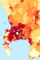
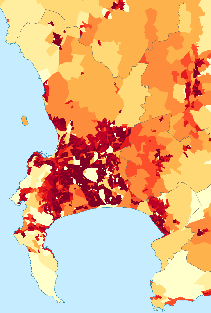
English: Population density map of the City of Cape Town, Western Cape, South Africa, from the 2011 Census, at the "Small Area" level.
<1 inhabitant/km²
1–3 inhabitants/km²
3–10 inhabitants/km²
10–30 inhabitants/km²
30–100 inhabitants/km²
100–300 inhabitants/km²
300–1000 inhabitants/km²
1000–3000 inhabitants/km²
>3000 inhabitants/km² |
| תאריך יצירה | |
| מקור | Statistics South Africa's Census 2011 is the source of the basic population data. The map results from my own processing of the data. |
| יוצר | Htonl |
| אישורים והיתרים (שימוש חוזר בקובץ זה) |
http://beta2.statssa.gov.za/?page_id=425 |
רישיון
[עריכה]
The following license applies to the population data on which the map is based:
 |
The copyright holder of this file allows anyone to use it
for any purpose, provided that the user acknowledges Stats SA as the source of the basic data wherever they process, apply, utilise, publish or distribute the data, and also that they specify that the relevant application and analysis (where applicable) result from their own processing of the data..
Usage notes:
|
|
Please check that the conditions given above are compliant to the Commons licensing policy. Most importantly, derivative work and commercial use must be allowed.
|
The following tag applies to the map itself:
| ברצוני, בעלי זכויות היוצרים על יצירה זו, לשחרר יצירה זו לנחלת הכלל. זה תקף בכל העולם. יש מדינות שבהן הדבר אינו אפשרי על פי חוק, אם כך: אני מעניק לכל אחד את הזכות להשתמש בעבודה זו לכל מטרה שהיא, ללא תנאים כלשהם, אלא אם כן תנאים כאלה נדרשים על פי חוק. |
היסטוריית הקובץ
ניתן ללחוץ על תאריך/שעה כדי לראות את הקובץ כפי שנראה באותו זמן.
| תאריך/שעה | תמונה ממוזערת | ממדים | משתמש | הערה | |
|---|---|---|---|---|---|
| נוכחית | 18:05, 26 בספטמבר 2015 | | 1,140 × 771 (761 ק"ב) | Htonl (שיחה | תרומות) | style/size tweak |
| 14:25, 13 באוקטובר 2013 |  | 1,045 × 718 (505 ק"ב) | Htonl (שיחה | תרומות) | == {{int:filedesc}} == {{Information |Description={{en|1=Population density map of the City of Cape Town, Western Cape, South Africa, from the 2011 Census, at the "Small Area" level. {{legend|#ffffcc|<1 inhabitant/km²}} {{legend|#ffeda0|1–3 inhab... |
אין באפשרותך לדרוס את הקובץ הזה.
שימוש בקובץ
הדף הבא משתמש בקובץ הזה:
- File:Cape Town population density map.svg (הפניה של קובץ)
שימוש גלובלי בקובץ
אתרי הוויקי השונים הבאים משתמשים בקובץ זה:
- שימוש באתר be.wikipedia.org
- שימוש באתר de.wikipedia.org
- שימוש באתר en.wikipedia.org
- שימוש באתר gl.wikipedia.org
- שימוש באתר gu.wikipedia.org
- שימוש באתר he.wikipedia.org
- שימוש באתר hu.wikipedia.org
- שימוש באתר hy.wikipedia.org
- שימוש באתר ja.wikipedia.org
- שימוש באתר ka.wikipedia.org
- שימוש באתר ko.wikipedia.org
- שימוש באתר mk.wikipedia.org
- שימוש באתר nso.wikipedia.org
- שימוש באתר pt.wikipedia.org
- שימוש באתר ro.wikipedia.org
- שימוש באתר sw.wikipedia.org
- שימוש באתר uk.wikipedia.org
- שימוש באתר xh.wikipedia.org