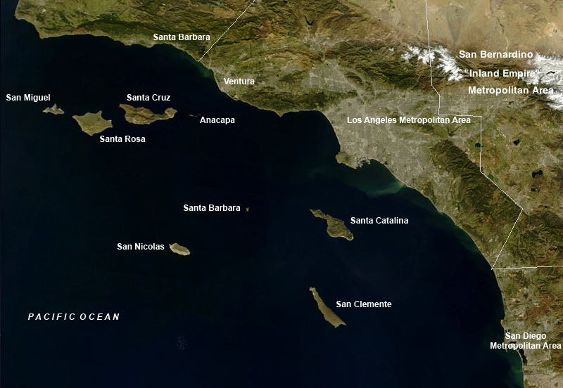
File:Channelislandsca.jpg
Wikimedia Commons, 자유로운 미디어 저장소
둘러보기로 이동
검색으로 이동
Channelislandsca.jpg (800 × 552 픽셀, 파일 크기: 129 KB, MIME 종류: image/jpeg)
파일 정보
구조화된 데이터
캡션
설명
이 파일이 나타내는 바에 대한 한 줄 설명을 추가합니다
Satellite image of the Channel Islands
파일 설명[편집]
| 설명Channelislandsca.jpg |
|
| 출처 |
이 미디어 파일은 출처 정보가 없습니다.
파일의 설명에 대한 내용을 편집해서 출처 정보를 제공해 주세요. |
| 저자 |
이 미디어 파일은 제작자 정보가 없습니다.
|
라이선스[편집]
| Public domainPublic domainfalsefalse |
| 이 파일은 NASA에서 제작하였으므로 퍼블릭 도메인입니다. NASA의 저작권 정책에 따르면 NASA의 자료는 명시하지 않는 이상 저작권의 보호를 받지 않습니다. (Template:PD-USGov, 또는 NASA 저작권 정책 문서, JPL 그림 사용 정책을 참고하세요.) |  | |
 |
주의사항:
|
기존 올리기 기록[편집]
The original description page was here. All following user names refer to en.wikipedia.
- 2005-10-02 06:06 Mikeetc 800×554×8 (318857 bytes) Map of Southern California with the Channel Islands identified Underlying map is an aerial map obtained from NASA (original: http://earthobservatory.nasa.gov/NaturalHazards/Archive/Nov2004/California_TMO_2004304_lrg.jpeg The labeling is by me {{PD}}
파일 역사
날짜/시간 링크를 클릭하면 해당 시간의 파일을 볼 수 있습니다.
| 날짜/시간 | 섬네일 | 크기 | 사용자 | 설명 | |
|---|---|---|---|---|---|
| 현재 | 2012년 2월 11일 (토) 23:05 |  | 800 × 552 (129 KB) | House1090 (토론 | 기여) | +SBD metro +divisions |
| 2012년 2월 11일 (토) 23:03 |  | 800 × 552 (129 KB) | House1090 (토론 | 기여) | +SBD metro +divisions | |
| 2007년 1월 1일 (월) 22:03 |  | 800 × 554 (311 KB) | Krzysier (토론 | 기여) | {{Information |Description=Map of Southern California with the Channel Islands identified Underlying map is an aerial map obtained from NASA (original: http://earthobservatory.nasa.gov/NaturalHazards/Archive/Nov2004/California_TMO_2004304_lrg.jpeg The |
이 파일을 덮어쓸 수 없습니다.
이 파일을 사용하는 문서
다음 문서 2개가 이 파일을 사용하고 있습니다:
이 파일을 사용하고 있는 모든 위키의 문서 목록
다음 위키에서 이 파일을 사용하고 있습니다:
- af.wikipedia.org에서 이 파일을 사용하고 있는 문서 목록
- ar.wikipedia.org에서 이 파일을 사용하고 있는 문서 목록
- br.wikipedia.org에서 이 파일을 사용하고 있는 문서 목록
- ca.wikipedia.org에서 이 파일을 사용하고 있는 문서 목록
- de.wikipedia.org에서 이 파일을 사용하고 있는 문서 목록
- en.wikipedia.org에서 이 파일을 사용하고 있는 문서 목록
- eo.wikipedia.org에서 이 파일을 사용하고 있는 문서 목록
- es.wikipedia.org에서 이 파일을 사용하고 있는 문서 목록
- eu.wikipedia.org에서 이 파일을 사용하고 있는 문서 목록
- fa.wikipedia.org에서 이 파일을 사용하고 있는 문서 목록
- fo.wikipedia.org에서 이 파일을 사용하고 있는 문서 목록
- fr.wikipedia.org에서 이 파일을 사용하고 있는 문서 목록
- he.wikipedia.org에서 이 파일을 사용하고 있는 문서 목록
- hy.wikipedia.org에서 이 파일을 사용하고 있는 문서 목록
- id.wikipedia.org에서 이 파일을 사용하고 있는 문서 목록
- it.wikipedia.org에서 이 파일을 사용하고 있는 문서 목록
- ja.wikipedia.org에서 이 파일을 사용하고 있는 문서 목록
- ko.wikipedia.org에서 이 파일을 사용하고 있는 문서 목록
- no.wikipedia.org에서 이 파일을 사용하고 있는 문서 목록
- pl.wikipedia.org에서 이 파일을 사용하고 있는 문서 목록
- pt.wikipedia.org에서 이 파일을 사용하고 있는 문서 목록
- ru.wikipedia.org에서 이 파일을 사용하고 있는 문서 목록
- tr.wikipedia.org에서 이 파일을 사용하고 있는 문서 목록
- uk.wikipedia.org에서 이 파일을 사용하고 있는 문서 목록
- www.wikidata.org에서 이 파일을 사용하고 있는 문서 목록
- zh.wikipedia.org에서 이 파일을 사용하고 있는 문서 목록
분류:
