File:Chariot spread.png
קפיצה לניווט
קפיצה לחיפוש
אין גרסה ברזולוציה גבוהה יותר.
Chariot_spread.png (400 × 231 פיקסלים, גודל הקובץ: 154 ק"ב, סוג MIME: image/png)
כיתובים
כיתובים
נא להוסיף משפט שמסביר מה הקובץ מייצג
| תיאור |
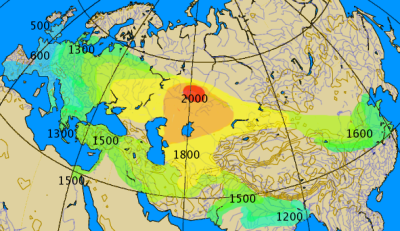
Historical spread of the chariot. This map combines various classes of information, historical and archaeological. The 'isochrones' as given should not be considered more than rough approximations, give or take a century.
|
||||||||
| תאריך יצירה | |||||||||
| מקור | נוצר על־ידי מעלה היצירה by by en:User:Dbachmann | ||||||||
| יוצר | by en:User:Dbachmann | ||||||||
| אישורים והיתרים (שימוש חוזר בקובץ זה) |
|
||||||||
| גרסאות אחרות |
|


היסטוריית הקובץ
ניתן ללחוץ על תאריך/שעה כדי לראות את הקובץ כפי שנראה באותו זמן.
| תאריך/שעה | תמונה ממוזערת | ממדים | משתמש | הערה | |
|---|---|---|---|---|---|
| נוכחית | 04:00, 27 בספטמבר 2021 | | 231 × 400 (154 ק"ב) | GPinkerton (שיחה | תרומות) | Reverted to version as of 14:14, 17 August 2005 (UTC) COM:CROP |
| 19:28, 2 במאי 2021 |  | 231 × 400 (161 ק"ב) | Claude Zygiel (שיחה | תרומות) | North Africa too (Raymond Vaufrey, Préhistoire de l'Afrique, tome II, Service des Publications de l'Université de Tunis, 1969) | |
| 14:14, 17 באוגוסט 2005 |  | 231 × 400 (154 ק"ב) | Dbachmann (שיחה | תרומות) | correction, labels | |
| 07:14, 17 באוגוסט 2005 |  | 202 × 350 (119 ק"ב) | Dbachmann (שיחה | תרומות) | by en:User:Dbachmann {{GFDL}} |
אין באפשרותך לדרוס את הקובץ הזה.
שימוש בקובץ
הדפים הבאים משתמשים בקובץ הזה:
שימוש גלובלי בקובץ
אתרי הוויקי השונים הבאים משתמשים בקובץ זה:
- שימוש באתר az.wikipedia.org
- שימוש באתר ba.wikipedia.org
- שימוש באתר bn.wikipedia.org
- שימוש באתר ca.wikipedia.org
- שימוש באתר cs.wikipedia.org
- שימוש באתר da.wikipedia.org
- שימוש באתר de.wikipedia.org
- שימוש באתר en.wikipedia.org
- שימוש באתר es.wikipedia.org
- שימוש באתר eu.wikipedia.org
- שימוש באתר fa.wikipedia.org
- שימוש באתר fi.wikipedia.org
- שימוש באתר fi.wikibooks.org
- שימוש באתר fr.wikipedia.org
- שימוש באתר hak.wikipedia.org
- שימוש באתר he.wikipedia.org
- שימוש באתר hu.wikipedia.org
- שימוש באתר hy.wikipedia.org
צפייה בשימושים גלובליים נוספים של קובץ זה.
מטא־נתונים
קטגוריות:
- Ancient four-wheeled chariots
- War chariots
- Maps of the Sintashta culture
- Archaeological maps
- Maps showing 2nd-millennium BC history
- Maps showing 1st-millennium BC history
- Maps showing 20th-century BC history
- Maps showing 19th-century BC history
- Maps showing 18th-century BC history
- Maps showing 17th-century BC history
- Maps showing 16th-century BC history
- 12th century BC
- 10th century BC
- 6th century BC
- 5th century BC
- Maps of the Bronze Age in China
- Isochrone maps
- Transport statistics