File:Charles Paultre, Carte physique & politique de la Syrie (FL37251427 3375223).jpg
קפיצה לניווט
קפיצה לחיפוש

גודל התצוגה המקדימה הזאת: 800 × 567 פיקסלים. רזולוציות אחרות: 320 × 227 פיקסלים | 640 × 454 פיקסלים | 1,024 × 726 פיקסלים | 1,280 × 907 פיקסלים | 2,560 × 1,815 פיקסלים | 22,160 × 15,707 פיקסלים.
לקובץ המקורי (22,160 × 15,707 פיקסלים, גודל הקובץ: 477.01 מ"ב, סוג MIME: image/jpeg)
כיתובים
כיתובים
נא להוסיף משפט שמסביר מה הקובץ מייצג
תקציר
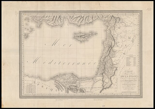
[עריכה]| Charles Paultre: Carte physique & politique de la Syrie
( |
||||||||||||||||||||||||
|---|---|---|---|---|---|---|---|---|---|---|---|---|---|---|---|---|---|---|---|---|---|---|---|---|
| אומן | ||||||||||||||||||||||||
| יוצרים נוספים | Lapie, M. (Pierre), 1779-1850 Blondeau, Alexandre Aubert, L. | |||||||||||||||||||||||
| כותרת |
Carte physique & politique de la Syrie |
|||||||||||||||||||||||
| מפרסם |
Lapie Picquet |
|||||||||||||||||||||||
| תיאור |
Carte physique & politique de la Syrie. Pour servier à l'Histoire des conquêtes du Général Bonaparte en Orient . Faite au Kaire en l'An 8, par Charles Paultre, Offier. d'Artrie. Légère, Aide-De-Camp du Général Kleber, Commt. en Chef, l'Armée Française en Egypte. Dessinée par Lapie, Ingr. Géographe. Gravé par Blondeau L'Ecriture gravée par L. Aubert. |
|||||||||||||||||||||||
| שפה | צרפתית | |||||||||||||||||||||||
| תאריך הוצאה לאור | 1803 | |||||||||||||||||||||||
| טכניקה | 1 sheet ; | |||||||||||||||||||||||
| ממדים | גובה: 66 ס"מ; רוחב: 92 ס"מ | |||||||||||||||||||||||
| אוסף |
|
|||||||||||||||||||||||
| מיקום נוכחי |
|
|||||||||||||||||||||||
| מיקום הוצאה | פריז | |||||||||||||||||||||||
| חיפוש בקטלוג מרחב | פריז | |||||||||||||||||||||||
| הערות | ||||||||||||||||||||||||
| IE PID | IE37251425 | |||||||||||||||||||||||
| רוזטה שם קובץ | FL37251427 | |||||||||||||||||||||||
| מזהה רשומה בספרייה הלאומית (P3959) | 990033752230205171 | |||||||||||||||||||||||
| חיפוש בקטלוג מרחב | צרפתית, Charles Paultre | |||||||||||||||||||||||
| חיפוש בקטלוג מרחב | Military mapsLapie Picquet | |||||||||||||||||||||||
| מקור/צלם |
|
|||||||||||||||||||||||
| גרסאות אחרות | ||||||||||||||||||||||||
| Jpg / Tif version |
|
|||||||||||||||||||||||

.jpg)

.jpg&action=edit§ion=1)
רישיון
[עריכה].jpg&action=edit§ion=2)
The copyright situation of this work is theoretically uncertain, because in the country of origin copyright lasts 70 years after the death of the author, and the date of the author's death is unknown. However, the date of creation of the work was over 120 years ago, and it is thus a reasonable assumption that the copyright has expired (see here for the community discussion). Do not use this template if the date of death of the author is known.
| |
| הקובץ הזה זוהה כקובץ חופשי מכל מגבלה ידועה תחת חוק זכויות היוצרים, כולל כל הזכויות הקשורות והסמוכות. | |
היסטוריית הקובץ
ניתן ללחוץ על תאריך/שעה כדי לראות את הקובץ כפי שנראה באותו זמן.
| תאריך/שעה | תמונה ממוזערת | ממדים | משתמש | הערה | |
|---|---|---|---|---|---|
| נוכחית | 20:02, 1 בספטמבר 2023 | | 15,707 × 22,160 (477.01 מ"ב) | Geagea (שיחה | תרומות) | pattypan 22.03 |
אין באפשרותך לדרוס את הקובץ הזה.
שימוש בקובץ
הדף הבא משתמש בקובץ הזה:
.jpg&oldid=854604689)