File:CharlestownSC1780.jpg
קפיצה לניווט
קפיצה לחיפוש

גודל התצוגה המקדימה הזאת: 800 × 548 פיקסלים. רזולוציות אחרות: 320 × 219 פיקסלים | 640 × 438 פיקסלים | 1,024 × 701 פיקסלים | 1,280 × 877 פיקסלים | 1,967 × 1,347 פיקסלים.
לקובץ המקורי (1,967 × 1,347 פיקסלים, גודל הקובץ: 859 ק"ב, סוג MIME: image/jpeg)
כיתובים
כיתובים
נא להוסיף משפט שמסביר מה הקובץ מייצג
תקציר
[עריכה]| תיאור |
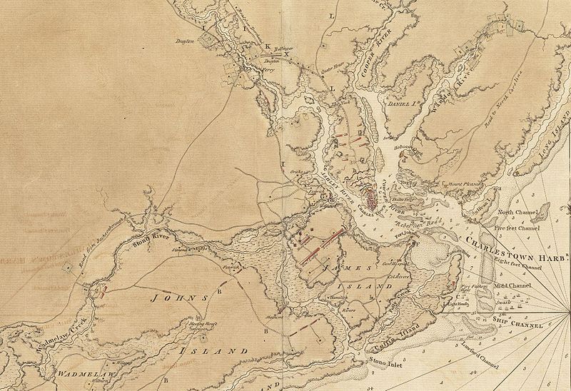
English: This is a detail of the source map, showing the port of Charleston, South Carolina and the coastline to the south as far as Johns Island. It has markings depicting Continental Army defenses set up in anticipation of British attack. The map was probably drawn by British engineers around the time of the 1780 Siege of Charleston. |
||||||
| תאריך יצירה | |||||||
| מקור |
From the Boston Public Library Digital Map Collection: http://maps.bpl.org/details_11098/ |
||||||
| יוצר | George Sproule | ||||||
| אישורים והיתרים (שימוש חוזר בקובץ זה) |
|


היסטוריית הקובץ
ניתן ללחוץ על תאריך/שעה כדי לראות את הקובץ כפי שנראה באותו זמן.
| תאריך/שעה | תמונה ממוזערת | ממדים | משתמש | הערה | |
|---|---|---|---|---|---|
| נוכחית | 13:13, 8 ביוני 2009 | | 1,347 × 1,967 (859 ק"ב) | Magicpiano (שיחה | תרומות) | {{Information |Description={{en|1=This is a detail of the source map, showing the port of Charleston, South Carolina and the coastline to the south as far as Johns Island. It has markings depicting Continental Army defenses set up in anticipation of Brit |
אין באפשרותך לדרוס את הקובץ הזה.
שימוש בקובץ
אין דפים המשתמשים בקובץ זה.
שימוש גלובלי בקובץ
אתרי הוויקי השונים הבאים משתמשים בקובץ זה:
- שימוש באתר ca.wikipedia.org
- שימוש באתר en.wikipedia.org
- שימוש באתר es.wikipedia.org
- שימוש באתר fr.wikipedia.org
- שימוש באתר he.wikipedia.org
- שימוש באתר ru.wikipedia.org
- שימוש באתר zh.wikipedia.org