File:Columbia Island - aerial view 2005.jpg
Columbia_Island_-_aerial_view_2005.jpg (473 × 406 פיקסלים, גודל הקובץ: 240 ק"ב, סוג MIME: image/jpeg)
כיתובים
כיתובים
תקציר
[עריכה]
| תיאור |
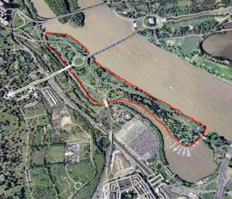
English: Aerial view of Columbia Island (outlined in red) in the Potomac River in Washington, D.C., in the United States.
Arlington Memorial Bridge enters the island from the northeast, connecting it to the Lincoln Memorial. A large memorial plaza and traffic circle, constructed in the 1930s, connects Arlington Memorial Bridge to Lee Highway, the George Washington Memorial Parkway, and the Boundary Channel Bridge. The many piers of the Columbia Island Marina jut into the Bounday Channel and Pentagon Lagoon on the southwest corner of the island. The Potomac River runs along the island to the northwest. The Lincoln Memorial and a portion of the Tidal Basin can also be seen. The Boundary Channel (west and southwest of the island) is part of the Potomac River. The Boundary Channel Bridge links Columbia Island to Memorial Drive and the ceremonial entrance to Arlington National Cemetery (left side of the image). The Pentagon can be seen to the bottom of the image, and just north of that its large parking lots. Upstream (upper center portion of this image) is the Theodore Roosevelt Bridge, and Theodore Roosevelt Island. The skyscrapers of Rossyln, Virginia, can just be seen in the far upper left corner of the image. |
| תאריך יצירה | |
| מקור | File:Washington_77.04477W_38.88819N.jpg |
| יוצר | NASA |
| קובץ זה נמצא ברשות הציבור מכיוון שהוא נוצר על ידי נאס"א. מדיניות זכויות היוצרים של נאס"א קובעת ש"חומרים של NASA אינם מוגנים בזכויות יוצרים אלא אם צוין אחרת". (דף מדיניות זכויות היוצרים ב-NASA או מדיניות שימוש בתמונות ב-JPL). | ||
 |
אזהרות:
|
רישיון
[עריכה]
היסטוריית הקובץ
ניתן ללחוץ על תאריך/שעה כדי לראות את הקובץ כפי שנראה באותו זמן.
| תאריך/שעה | תמונה ממוזערת | ממדים | משתמש | הערה | |
|---|---|---|---|---|---|
| נוכחית | 18:23, 6 במאי 2013 | | 406 × 473 (240 ק"ב) | Tim1965 (שיחה | תרומות) | {{Information |Description ={{en|1=Aerial view of Columbia Island (outlined in red) in the Potomac River in Washington, D.C., in the United States. Arlington Memorial Bridge enters the island from the northeast, connecting it to the Lincoln Memoria... |
אין באפשרותך לדרוס את הקובץ הזה.
שימוש בקובץ
הדפים הבאים משתמשים בקובץ הזה:
שימוש גלובלי בקובץ
אתרי הוויקי השונים הבאים משתמשים בקובץ זה:
- שימוש באתר ceb.wikipedia.org
- שימוש באתר en.wikipedia.org
- שימוש באתר fr.wikipedia.org
- שימוש באתר he.wikipedia.org
- שימוש באתר ur.wikipedia.org
- שימוש באתר www.wikidata.org