File:County Line Bridge west of Columbus Grove.jpg
קפיצה לניווט
קפיצה לחיפוש

גודל התצוגה המקדימה הזאת: 800 × 532 פיקסלים. רזולוציות אחרות: 320 × 213 פיקסלים | 640 × 426 פיקסלים | 1,024 × 681 פיקסלים | 1,280 × 851 פיקסלים | 2,560 × 1,702 פיקסלים | 6,016 × 4,000 פיקסלים.
לקובץ המקורי (6,016 × 4,000 פיקסלים, גודל הקובץ: 6.52 מ"ב, סוג MIME: image/jpeg)
כיתובים
כיתובים
נא להוסיף משפט שמסביר מה הקובץ מייצג
|
This is an image of a place or building that is listed on the National Register of Historic Places in the United States of America. Its reference number is 98000513. |
| מיקום המצלמה | | תמונה זו ותמונות נוספות במיקום: OpenStreetMap |
|---|
| תיאור |
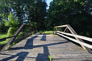
English: Southern end of the abandoned County Line Bridge, which formerly carried County Line Road (Louisa County to the right and Washington County to the left) over Long Creek just west of Columbus Grove, Iowa, United States. The old right-of-way remains on the map, but mosquitos, not humans, are its primary users, while the bridge's wooden floor and railings are unable to hold even the weight of a human. Built in 1893, it is listed on the National Register of Historic Places. |
||
| תאריך יצירה | צולם ב- 27 ביולי 2015 | ||
| מקור | נוצר על־ידי מעלה היצירה | ||
| יוצר | Nyttend | ||
| אישורים והיתרים (שימוש חוזר בקובץ זה) |
|
היסטוריית הקובץ
ניתן ללחוץ על תאריך/שעה כדי לראות את הקובץ כפי שנראה באותו זמן.
| תאריך/שעה | תמונה ממוזערת | ממדים | משתמש | הערה | |
|---|---|---|---|---|---|
| נוכחית | 03:27, 13 באוגוסט 2015 | | 4,000 × 6,016 (6.52 מ"ב) | Nyttend (שיחה | תרומות) | {{NRHP|98000513}} {{Location|41|16|1|N|91|29|6.5|W}} {{Information |Description={{en|Southern end of the abandoned {{w|County Line Bridge (Columbus Grove, Iowa)|County Line Bridge}}, which formerly carried County Line Road ({{w|Louisa County, Iowa|Loui... |
אין באפשרותך לדרוס את הקובץ הזה.
שימוש בקובץ
אין דפים המשתמשים בקובץ זה.
שימוש גלובלי בקובץ
אתרי הוויקי השונים הבאים משתמשים בקובץ זה:
- שימוש באתר de.wikipedia.org
- שימוש באתר en.wikipedia.org
- שימוש באתר www.wikidata.org
מטא־נתונים
קטגוריות:
- Built in Iowa in 1893
- Bridges in the United States completed in 1893
- 1890s bridges in Iowa
- Abandoned road bridges in the United States
- Bridges across county lines
- Bridges in Louisa County, Iowa
- Bridges in Washington County, Iowa
- National Register of Historic Places in Louisa County, Iowa
- National Register of Historic Places in Washington County, Iowa
- Pony truss bridges in Iowa