File:Delineatio Palaestinae sive Terre Sancta maxime Had Relandi mentem composita (FL48326069 3939345).jpg
קפיצה לניווט
קפיצה לחיפוש
גודל התצוגה המקדימה הזאת: 522 × 600 פיקסלים. רזולוציות אחרות: 209 × 240 פיקסלים | 418 × 480 פיקסלים | 668 × 768 פיקסלים | 891 × 1,024 פיקסלים | 1,782 × 2,048 פיקסלים | 3,023 × 3,474 פיקסלים.
לקובץ המקורי (3,023 × 3,474 פיקסלים, גודל הקובץ: 11.54 מ"ב, סוג MIME: image/jpeg)
כיתובים
כיתובים
נא להוסיף משפט שמסביר מה הקובץ מייצג
תקציר
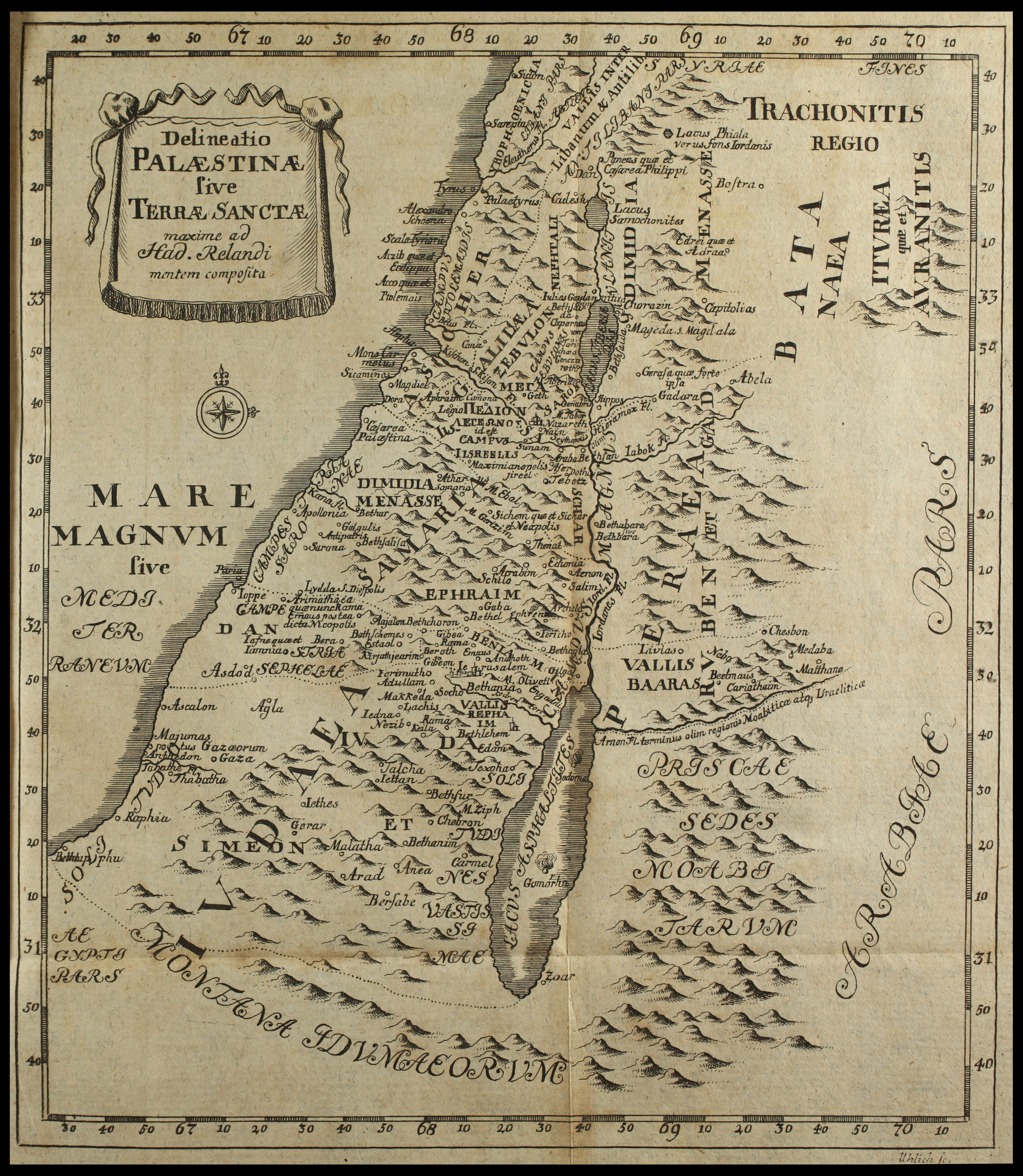
[עריכה]| Delineatio Palaestinae sive Terre Sancta maxime Had Relandi mentem composita
( |
||||||||||||||||||||||||
|---|---|---|---|---|---|---|---|---|---|---|---|---|---|---|---|---|---|---|---|---|---|---|---|---|
| כותרת |
Delineatio Palaestinae sive Terre Sancta maxime Had Relandi mentem composita |
|||||||||||||||||||||||
| מפרסם |
Samuel Benjamin Walther |
|||||||||||||||||||||||
| תיאור |
Delineatio Palaestinae sive Terre Sancta maxime Had Relandi mentem composita. Uhlich Sc. |
|||||||||||||||||||||||
| שפה | לטינית | |||||||||||||||||||||||
| תאריך הוצאה לאור | 1734 | |||||||||||||||||||||||
| טכניקה | 1 online resource (1 map). | |||||||||||||||||||||||
| אוסף |
|
|||||||||||||||||||||||
| מיקום נוכחי |
|
|||||||||||||||||||||||
| מיקום הוצאה | לייפציג | |||||||||||||||||||||||
| חיפוש בקטלוג מרחב | לייפציג | |||||||||||||||||||||||
| הערות | Digital image of the original in Amir Cahanovitc Collection, Israel. ACC 2095-1.; From: Biblia sacra : ex Sebastiani Castellionis interpretatione et postrema recognitione : Praeter diss. C. Wollii de eo quod pulchrum est in hac versione; Iam accesserunt notae ex margine subiectae chartae geographicae et Templi Salomonis delineatio. Versionem ex primis edd. emendavit et praefatus est Jo. Ludolph. Bunemann. | |||||||||||||||||||||||
| IE PID | IE48326067 | |||||||||||||||||||||||
| רוזטה שם קובץ | FL48326069 | |||||||||||||||||||||||
| מזהה רשומה בספרייה הלאומית (P3959) | 990039393450205171 | |||||||||||||||||||||||
| חיפוש בקטלוג מרחב | לטינית | |||||||||||||||||||||||
| חיפוש בקטלוג מרחב | Twelve tribes of IsraelMapsSamuel Benjamin Walther | |||||||||||||||||||||||
| מקור/צלם |
|
|||||||||||||||||||||||
| גרסאות אחרות | ||||||||||||||||||||||||
| Jpg / Tif version |
|
|||||||||||||||||||||||

.jpg)

.jpg&action=edit§ion=1)
רישיון
[עריכה].jpg&action=edit§ion=2)
The copyright situation of this work is theoretically uncertain, because in the country of origin copyright lasts 70 years after the death of the author, and the date of the author's death is unknown. However, the date of creation of the work was over 120 years ago, and it is thus a reasonable assumption that the copyright has expired (see here for the community discussion). Do not use this template if the date of death of the author is known.
| |
| הקובץ הזה זוהה כקובץ חופשי מכל מגבלה ידועה תחת חוק זכויות היוצרים, כולל כל הזכויות הקשורות והסמוכות. | |
היסטוריית הקובץ
ניתן ללחוץ על תאריך/שעה כדי לראות את הקובץ כפי שנראה באותו זמן.
| תאריך/שעה | תמונה ממוזערת | ממדים | משתמש | הערה | |
|---|---|---|---|---|---|
| נוכחית | 02:21, 4 בספטמבר 2023 | | 3,474 × 3,023 (11.54 מ"ב) | Geagea (שיחה | תרומות) | pattypan 22.03 |
אין באפשרותך לדרוס את הקובץ הזה.
שימוש בקובץ
הדף הבא משתמש בקובץ הזה:
.jpg&oldid=798622516)