File:Description de la Terre Saincte, contenant les lieux dont est faicte mention aux quatre Evangelistes (FL45604177 3939933).jpg
קפיצה לניווט
קפיצה לחיפוש
גודל התצוגה המקדימה הזאת: 383 × 600 פיקסלים. רזולוציות אחרות: 153 × 240 פיקסלים | 306 × 480 פיקסלים | 490 × 768 פיקסלים | 654 × 1,024 פיקסלים | 1,307 × 2,048 פיקסלים | 2,959 × 4,635 פיקסלים.
לקובץ המקורי (2,959 × 4,635 פיקסלים, גודל הקובץ: 5.83 מ"ב, סוג MIME: image/jpeg)
כיתובים
כיתובים
נא להוסיף משפט שמסביר מה הקובץ מייצג
תקציר
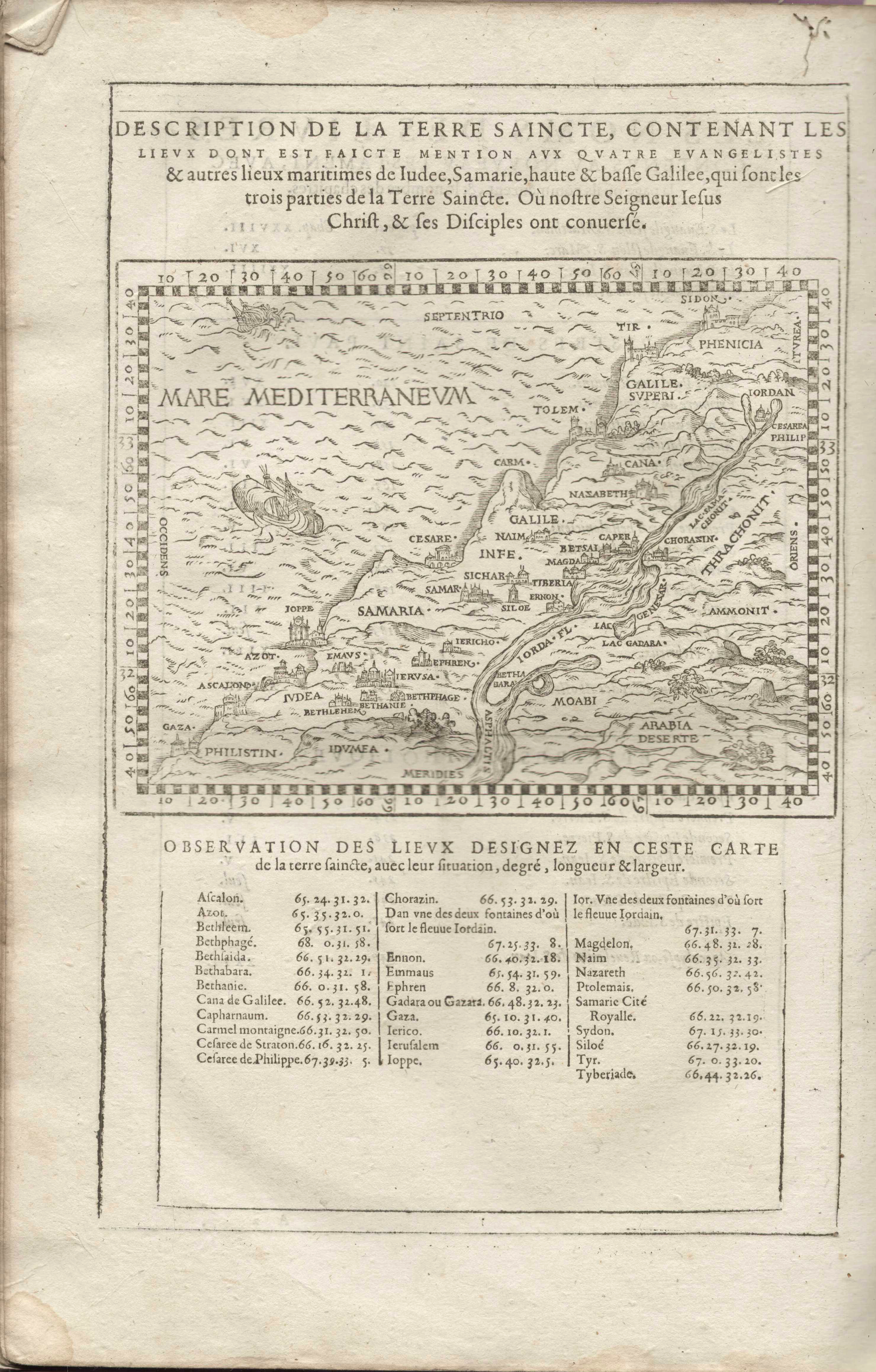
[עריכה]| Description de la Terre Saincte, contenant les lieux dont est faicte mention aux quatre Evangelistes
( |
||||||||||||||||||||||||
|---|---|---|---|---|---|---|---|---|---|---|---|---|---|---|---|---|---|---|---|---|---|---|---|---|
| כותרת |
Description de la Terre Saincte, contenant les lieux dont est faicte mention aux quatre Evangelistes |
|||||||||||||||||||||||
| מפרסם |
Jean Pillehotte |
|||||||||||||||||||||||
| תיאור |
Description de la Terre Saincte, contenant les lieux dont est faicte mention aux quatre Evangelistes & autres liux maritimes de Iudee, Samarie, haute & basse Galilee, qui sont les trois parties de la Terre Saincte. Ou nostre Seigneur Iesus Christ, & ses Diciples ont conuerse.. |
|||||||||||||||||||||||
| שפה | צרפתית | |||||||||||||||||||||||
| תאריך הוצאה לאור | 1603 | |||||||||||||||||||||||
| טכניקה | 1 online resource (1 map). | |||||||||||||||||||||||
| אוסף |
|
|||||||||||||||||||||||
| מיקום נוכחי |
|
|||||||||||||||||||||||
| מיקום הוצאה | ליון | |||||||||||||||||||||||
| חיפוש בקטלוג מרחב | ליון | |||||||||||||||||||||||
| הערות | Digital image of the original in Amir Cahanovitc Collection, Israel. ACC 1768-3.; Digital image received from donor.; From: La saincte bible contenant le vieil & nouveau testament, traduite de latin en françois par les docteurs en la faculté de théologie à Louvain. | |||||||||||||||||||||||
| IE PID | IE45604173 | |||||||||||||||||||||||
| רוזטה שם קובץ | FL45604177 | |||||||||||||||||||||||
| מזהה רשומה בספרייה הלאומית (P3959) | 990039399330205171 | |||||||||||||||||||||||
| חיפוש בקטלוג מרחב | צרפתית | |||||||||||||||||||||||
| חיפוש בקטלוג מרחב | Jean Pillehotte | |||||||||||||||||||||||
| מקור/צלם |
|
|||||||||||||||||||||||
| גרסאות אחרות | ||||||||||||||||||||||||
| Jpg / Tif version |
|
|||||||||||||||||||||||

.jpg)

.jpg&action=edit§ion=1)
רישיון
[עריכה].jpg&action=edit§ion=2)
The copyright situation of this work is theoretically uncertain, because in the country of origin copyright lasts 70 years after the death of the author, and the date of the author's death is unknown. However, the date of creation of the work was over 120 years ago, and it is thus a reasonable assumption that the copyright has expired (see here for the community discussion). Do not use this template if the date of death of the author is known.
| |
| הקובץ הזה זוהה כקובץ חופשי מכל מגבלה ידועה תחת חוק זכויות היוצרים, כולל כל הזכויות הקשורות והסמוכות. | |
היסטוריית הקובץ
ניתן ללחוץ על תאריך/שעה כדי לראות את הקובץ כפי שנראה באותו זמן.
| תאריך/שעה | תמונה ממוזערת | ממדים | משתמש | הערה | |
|---|---|---|---|---|---|
| נוכחית | 20:22, 5 בספטמבר 2023 | | 4,635 × 2,959 (5.83 מ"ב) | Geagea (שיחה | תרומות) | pattypan 22.03 |
אין באפשרותך לדרוס את הקובץ הזה.
שימוש בקובץ
הדף הבא משתמש בקובץ הזה:
.jpg&oldid=798742364)