File:Dust storm over Libya.jpg

원본 파일 (2,000 × 1,556 픽셀, 파일 크기: 839 KB, MIME 종류: image/jpeg)
캡션
설명
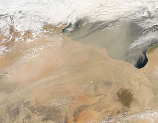
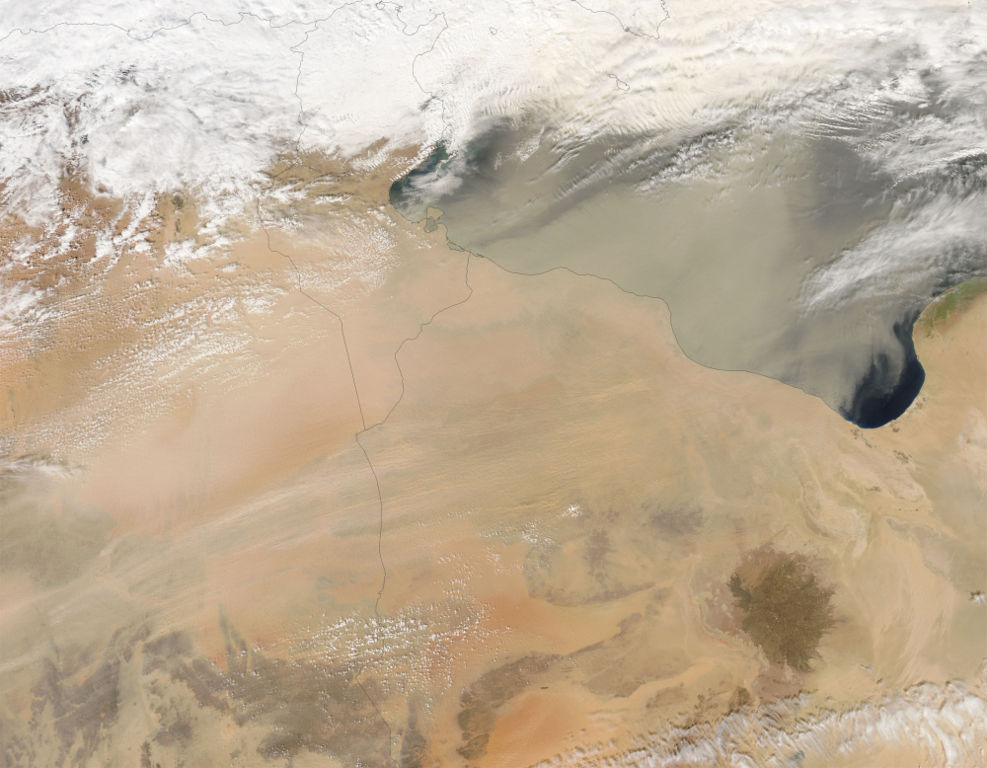
Dust Storm over Libya and Egypt A thin sheet of dust blew northeastward from deserts in northern Africa and out across the Mediterranean Sea (upper right) on March 1, 2005. The orange-colored sands of eastern Algeria are thickly veiled with light-colored dust, which thins as it spreads more widely over Tunisia and Libya. The dust weaves both under and over clouds in different places over the Mediterranean. At the far right edge, the clouds appear bright white, and appear to be casting a shadow on the dust plume below them. At top center, dust appears to be above the clouds, giving them a dirty appearance. This image was made from data collected by the Moderate Resolution Imaging Spectroradiometer (MODIS) on NASA’s Aqua satellite.
NASA image courtesy Jeff Schmaltz, MODIS Rapid Response Team, NASA-GSFC
http://earthobservatory.nasa.gov/NaturalHazards/natural_hazards_v2.php3?img_id=12746 archive copy at the Wayback Machine
| 이 파일은 NASA에서 제작하였으므로 퍼블릭 도메인입니다. NASA의 저작권 정책에 따르면 NASA의 자료는 명시하지 않는 이상 저작권의 보호를 받지 않습니다. (Template:PD-USGov, 또는 NASA 저작권 정책 문서, JPL 그림 사용 정책을 참고하세요.) | ||
 |
주의사항:
|
파일 역사
날짜/시간 링크를 클릭하면 해당 시간의 파일을 볼 수 있습니다.
| 날짜/시간 | 섬네일 | 크기 | 사용자 | 설명 | |
|---|---|---|---|---|---|
| 현재 | 2005년 10월 25일 (화) 12:56 | | 2,000 × 1,556 (839 KB) | Brian0918 (토론 | 기여) | Dust Storm over Libya and Egypt A thin sheet of dust blew northeastward from deserts in northern Africa and out across the Mediterranean Sea (upper right) on March 1, 2005. The orange-colored sands of eastern Algeria are thickly veiled with light-colored |
이 파일을 덮어쓸 수 없습니다.
이 파일을 사용하는 문서
다음 문서 1개가 이 파일을 사용하고 있습니다:
이 파일을 사용하고 있는 모든 위키의 문서 목록
다음 위키에서 이 파일을 사용하고 있습니다:
- ar.wikipedia.org에서 이 파일을 사용하고 있는 문서 목록
- bg.wikipedia.org에서 이 파일을 사용하고 있는 문서 목록
- bh.wikipedia.org에서 이 파일을 사용하고 있는 문서 목록
- bn.wikipedia.org에서 이 파일을 사용하고 있는 문서 목록
- da.wikipedia.org에서 이 파일을 사용하고 있는 문서 목록
- de.wikipedia.org에서 이 파일을 사용하고 있는 문서 목록
- el.wikipedia.org에서 이 파일을 사용하고 있는 문서 목록
- en.wikipedia.org에서 이 파일을 사용하고 있는 문서 목록
- eo.wikipedia.org에서 이 파일을 사용하고 있는 문서 목록
- eu.wikipedia.org에서 이 파일을 사용하고 있는 문서 목록
- fa.wikipedia.org에서 이 파일을 사용하고 있는 문서 목록
- fr.wikipedia.org에서 이 파일을 사용하고 있는 문서 목록
- gd.wikipedia.org에서 이 파일을 사용하고 있는 문서 목록
- ig.wikipedia.org에서 이 파일을 사용하고 있는 문서 목록
- ja.wikipedia.org에서 이 파일을 사용하고 있는 문서 목록
- ka.wikipedia.org에서 이 파일을 사용하고 있는 문서 목록
- kk.wikipedia.org에서 이 파일을 사용하고 있는 문서 목록
- ko.wikipedia.org에서 이 파일을 사용하고 있는 문서 목록
- lt.wikipedia.org에서 이 파일을 사용하고 있는 문서 목록
- mk.wikipedia.org에서 이 파일을 사용하고 있는 문서 목록
- ml.wikipedia.org에서 이 파일을 사용하고 있는 문서 목록
- nn.wikipedia.org에서 이 파일을 사용하고 있는 문서 목록
- no.wikipedia.org에서 이 파일을 사용하고 있는 문서 목록
- pt.wikipedia.org에서 이 파일을 사용하고 있는 문서 목록
- ru.wikipedia.org에서 이 파일을 사용하고 있는 문서 목록
- sv.wikipedia.org에서 이 파일을 사용하고 있는 문서 목록
- uk.wikipedia.org에서 이 파일을 사용하고 있는 문서 목록
메타데이터
- Photos of dust storms by the Aqua (satellite) MODIS
- NASA MODIS images of Africa
- Satellite pictures of Libya
- Satellite pictures of Tunisia
- Causes of erosion
- Khamsin
- Dust storms in Egypt
- Dust storms in Libya
- Aeolian sediment transport in Africa
- Aeolian sediment transport in Libya
- Dust storms in Tunisia
- Gulf of Sirte