File:Edinburgh tramway map.svg
קפיצה לניווט
קפיצה לחיפוש

גודל התצוגה המקדימה הזאת מסוג PNG של קובץ ה־SVG הזה: 800 × 259 פיקסלים. רזולוציות אחרות: 320 × 104 פיקסלים | 640 × 207 פיקסלים | 1,024 × 331 פיקסלים | 1,280 × 414 פיקסלים | 2,560 × 828 פיקסלים | 850 × 275 פיקסלים.
לקובץ המקורי (קובץ SVG, הגודל המקורי: 850 × 275 פיקסלים, גודל הקובץ: 202 ק"ב)
כיתובים
כיתובים
נא להוסיף משפט שמסביר מה הקובץ מייצג
תקציר[עריכה]
| תיאור |
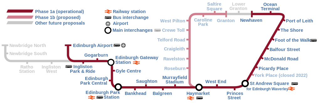
English: Map of the Edinburgh Trams system, showing the as built line (opened May 2014) alongside the various proposed lines that were ultimately abandoned or postponed indefinitely. |
| תאריך יצירה | |
| מקור | נוצר על־ידי מעלה היצירה |
| יוצר | DavidArthur |
רישיון[עריכה]
אני, בעל זכויות היוצרים על היצירה הזאת, מפרסם אותה בזאת תחת הרישיונות הבאים:

|
מוענקת בכך הרשות להעתיק, להפיץ או לשנות את המסמך הזה, לפי תנאי הרישיון לשימוש חופשי במסמכים של גנו, גרסה 1.2 או כל גרסה מאוחרת יותר שתפורסם על־ידי המוסד לתוכנה חופשית; ללא פרקים קבועים, ללא טקסט עטיפה קדמית וללא טקסט עטיפה אחורית. עותק של הרישיון כלול בפרק שכותרתו הרישיון לשימוש חופשי במסמכים של גנו. |
This file is licensed under the Creative Commons Attribution-Share Alike 4.0 International, 3.0 Unported, 2.5 Generic, 2.0 Generic and 1.0 Generic license.
- הנכם רשאים:
- לשתף – להעתיק, להפיץ ולהעביר את העבודה
- לערבב בין עבודות – להתאים את העבודה
- תחת התנאים הבאים:
- ייחוס – יש לתת ייחוס הולם, לתת קישור לרישיון, ולציין אם נעשו שינויים. אפשר לעשות את זה בכל צורה סבירה, אבל לא בשום צורה שמשתמע ממנה שמעניק הרישיון תומך בך או בשימוש שלך.
- שיתוף זהה – אם תיצרו רמיקס, תשנו, או תבנו על החומר, חובה עליכם להפיץ את התרומות שלך לפי תנאי רישיון זהה או תואם למקור.
הנכם מוזמנים לבחור את הרישיון הרצוי בעיניכם.
היסטוריית הקובץ
ניתן ללחוץ על תאריך/שעה כדי לראות את הקובץ כפי שנראה באותו זמן.
| תאריך/שעה | תמונה ממוזערת | ממדים | משתמש | הערה | |
|---|---|---|---|---|---|
| נוכחית | 14:58, 17 ביוני 2023 | 275 × 850 (202 ק"ב) | Cnbrb (שיחה | תרומות) | fix text embedding | |
| 14:30, 17 ביוני 2023 | 275 × 850 (159 ק"ב) | Cnbrb (שיחה | תרומות) | newhaven branch now operational; typographical and symbolic improvements | ||
| 14:06, 11 במאי 2020 | 275 × 850 (88 ק"ב) | Angryskies (שיחה | תרומות) | '''West End - Princes Street''' tram stop renamed to '''West End''' | ||
| 20:17, 21 באפריל 2020 | 275 × 850 (90 ק"ב) | Angryskies (שיחה | תרומות) | Updated details of line to Newhaven under construction. | ||
| 13:06, 25 בספטמבר 2017 | 275 × 850 (91 ק"ב) | Sladen (שיחה | תרומות) | Inclusion of Edinburgh Gateway Station. | ||
| 18:08, 28 בספטמבר 2013 | 275 × 850 (88 ק"ב) | Sladen (שיחה | תרומות) | Rename "Shandwick Place" to "West End – Princes Street" per {{cite news|url=http://www.edinburghnews.scotsman.com/news/transport/trams-shandwick-place-stop-renamed-princes-street-1-3106746|title=Trams: Shandwick Place stop renamed Princes Street|firs... | ||
| 13:13, 9 בפברואר 2013 | 275 × 850 (88 ק"ב) | Sladen (שיחה | תרומות) | Split Phase 1a (as built) from Phase 1a (not built) and show as dotted line. Reduce prominence of planned stations to focus on as-built section. Tweak key to include difference, and add "Airport" + pictogram for completeness. + remove errornous extr... | ||
| 13:12, 9 בפברואר 2013 | 275 × 850 (88 ק"ב) | Sladen (שיחה | תרומות) | Split Phase 1a (as built) from Phase 1a (not built) and show as dotted line. Reduce prominence of planned stations to focus on as-built section. Tweak key to include difference, and add "Airport" + pictogram for completeness. | ||
| 17:48, 17 בנובמבר 2007 | 275 × 850 (73 ק"ב) | DavidArthur (שיחה | תרומות) | {{Information |Description={{en|20px|English A map of the proposed Edinburgh tramway.}} |Source=self-made |Date=17 November 2007 |Author= DavidArthur |Permission= |
אין באפשרותך לדרוס את הקובץ הזה.
שימוש בקובץ
הדפים הבאים משתמשים בקובץ הזה:
- Edinburgh Trams: maps
- User:Chumwa/OgreBot/Potential transport maps/2017 September 25/Overflow 1
- User:Chumwa/OgreBot/Public transport information/2017 September 21-30
- User:Chumwa/OgreBot/Public transport information/2020 April 21-30
- User:Chumwa/OgreBot/Public transport information/2020 May 11-20
- User:Chumwa/OgreBot/Public transport information/2023 June 11-20
- User:Chumwa/OgreBot/Transport Maps/2017 September 25/Overflow 1
- User:Chumwa/OgreBot/Transport Maps/2020 April 21-30
- User:Chumwa/OgreBot/Transport Maps/2020 May 11-20
- User:Chumwa/OgreBot/Transport Maps/2023 June 11-20
- User:Chumwa/OgreBot/Travel and communication maps/2017 September 25/Overflow 1
- User:Mattbuck/Railways/2017 September 21-30
- User:Mattbuck/Railways/2020 April
- User:Mattbuck/Railways/2020 May
- User:Mattbuck/Railways/2023 June
- File:Edinburgh Trams line 1.png
- File:Edinburgh Trams line 2.png
- File:Edinburgh Trams line 3.png
- File:Edinburgh trams initial service.png
- Category:Edinburgh Trams
- Category:Edinburgh Trams stops
שימוש גלובלי בקובץ
אתרי הוויקי השונים הבאים משתמשים בקובץ זה:
- שימוש באתר cs.wikipedia.org
- שימוש באתר cy.wikipedia.org
- שימוש באתר de.wikipedia.org
- שימוש באתר en.wikipedia.org
- שימוש באתר eo.wikipedia.org
- שימוש באתר es.wikipedia.org
- שימוש באתר fi.wikipedia.org
- שימוש באתר fr.wikipedia.org
- שימוש באתר he.wikipedia.org
- שימוש באתר he.wikivoyage.org
- שימוש באתר ja.wikipedia.org
- שימוש באתר www.wikidata.org
- שימוש באתר zh.wikipedia.org