File:Ensanche - eixample - Barcelona.jpg
לקובץ המקורי (2,498 × 1,659 פיקסלים, גודל הקובץ: 887 ק"ב, סוג MIME: image/jpeg)
כיתובים
כיתובים
תקציר
[עריכה]
| תיאור |
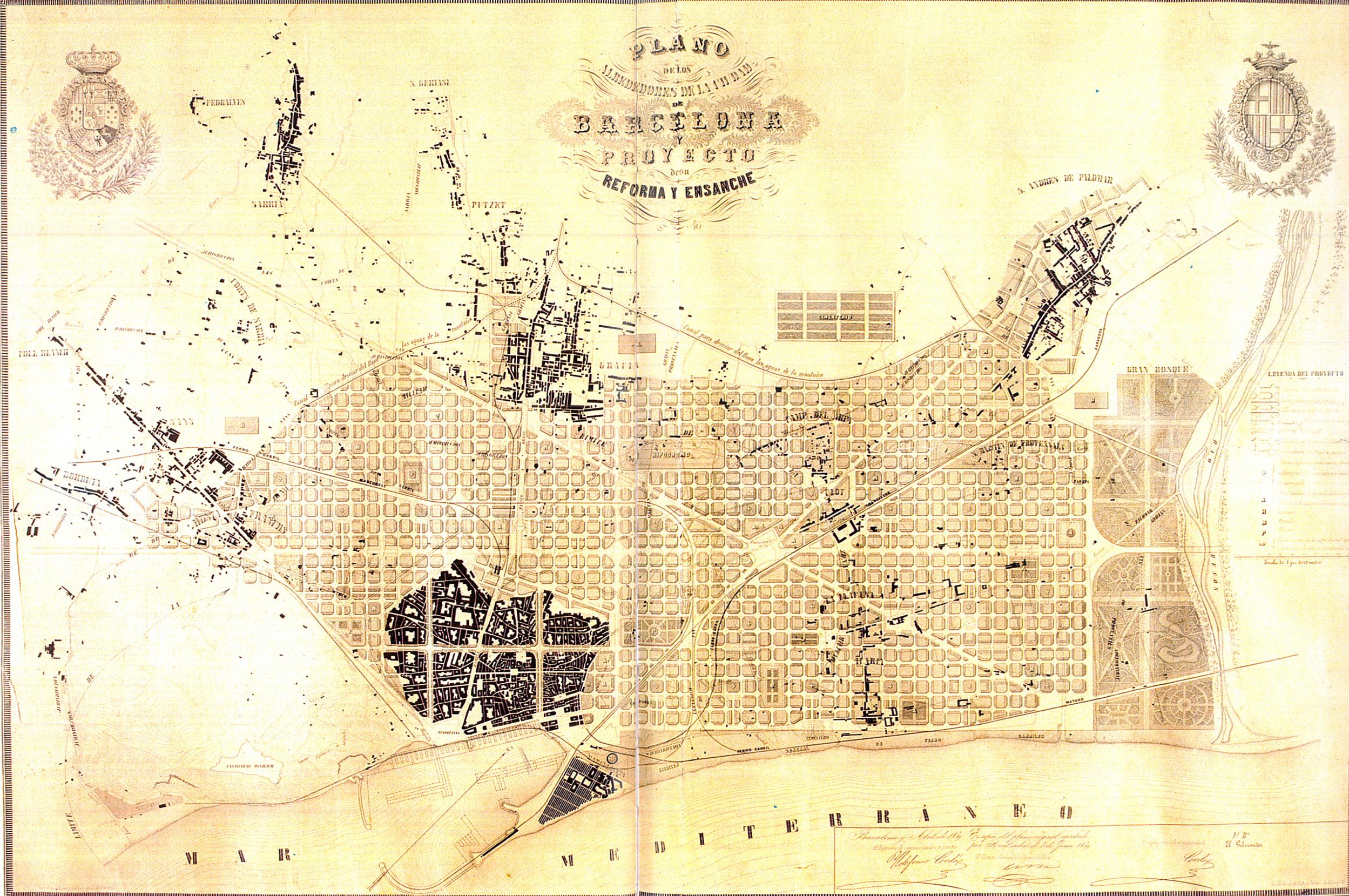
Català: Eixample de Barcelona. Pla dels voltants de la ciutat de Barcelona i del projecte per a la seva millora i ampliació, 1859.
English: Enlargement map of Barcelona. Map of the neighborhoods of the city of Barcelona and project for its improvements and enlargement, 1859.
Español: Ensanche de Barcelona. Plan de los alrededores de la ciudad de Barcelona y del proyecto para su mejora y ampliación, 1859.
Français : Aggrandissement de Barcelone. Carte des environs de la ville de Barcelone et projet d'amélioration et d'aggrandissement, 1859. |
|||||||||
| תאריך יצירה | ||||||||||
| מקור | Museu d'Historia de la Ciutat, Barcelona. | |||||||||
| יוצר |
Ildefons Cerdà i Sunyer |
|||||||||
| Geotemporal data | ||||||||||
| Bounding box |
|
|||||||||
| Georeferencing | ||||||||||
| גרסאות אחרות |
   |
|||||||||
רישיון
[עריכה]
|
עבודת אמנות דו-מימדית זו המוצגת בתמונה שוחררה לרשות הציבור בכל העולם בעקבות תאריך מותו של היוצר, או תאריך פרסום היצירה. לפיכך, תצלום היצירה גם הוא ברשות הציבור.
הודעה זו תקפה לגבי התצלומים שנוצרו בארצות הברית, בגרמניה ובמדינות רבות נוספות. {{PD-Art}} template without license parameter: please specify why the underlying work is public domain in both the source country and the United States
(Usage: {{PD-Art|1=|deathyear=''year of author's death''|country=''source country''}}, where parameter 1= can be PD-old-auto, PD-old-auto-expired, PD-old-auto-1996, PD-old-100 or similar. See Commons:Multi-license copyright tags for more information.) | ||||
היסטוריית הקובץ
ניתן ללחוץ על תאריך/שעה כדי לראות את הקובץ כפי שנראה באותו זמן.
| תאריך/שעה | תמונה ממוזערת | ממדים | משתמש | הערה | |
|---|---|---|---|---|---|
| נוכחית | 14:01, 12 באפריל 2010 | | 1,659 × 2,498 (887 ק"ב) | Lironcareto (שיחה | תרומות) | Larger image. Better resolution. Category:1850 Category:Maps of Eixample Category:Urban studies and planning Category:Maps of the history of Barcelona Category:Ildefons Cerdà |
| 15:55, 14 בספטמבר 2005 |  | 431 × 635 (43 ק"ב) | Tony Rotondas (שיחה | תרומות) | *'''Title''' {{english}} Eixample of Barcelona {{spanish}} Ensanche de Barcelona. *'''Description''' {{english}} Plan of the environs of the city of Barcelona and project for its improvements and enlargement, 1859. {{spanish}} Plan de los alrededores de |
אין באפשרותך לדרוס את הקובץ הזה.
שימוש בקובץ
הדפים הבאים משתמשים בקובץ הזה:
שימוש גלובלי בקובץ
אתרי הוויקי השונים הבאים משתמשים בקובץ זה:
- שימוש באתר an.wikipedia.org
- שימוש באתר ca.wikipedia.org
- שימוש באתר cs.wikipedia.org
- שימוש באתר de.wikipedia.org
- שימוש באתר en.wikipedia.org
- שימוש באתר eo.wikipedia.org
- שימוש באתר fi.wikipedia.org
- שימוש באתר gl.wikipedia.org
- שימוש באתר he.wikipedia.org
- שימוש באתר id.wikipedia.org
- שימוש באתר it.wikipedia.org
- שימוש באתר nl.wikipedia.org
- שימוש באתר oc.wikipedia.org
- שימוש באתר pl.wikipedia.org
- שימוש באתר pt.wikipedia.org
- שימוש באתר simple.wikipedia.org
- שימוש באתר sq.wikipedia.org
- שימוש באתר sr.wikipedia.org
- שימוש באתר sv.wikipedia.org
- שימוש באתר zh.wikipedia.org