File:Eta 2020 track.png
둘러보기로 이동
검색으로 이동

미리 보기 크기: 800 × 571 픽셀 다른 해상도: 320 × 228 픽셀 | 640 × 457 픽셀 | 1,024 × 730 픽셀 | 1,280 × 913 픽셀 | 2,700 × 1,926 픽셀
원본 파일 (2,700 × 1,926 픽셀, 파일 크기: 3.43 MB, MIME 종류: image/png)
캡션
설명
이 파일이 나타내는 바에 대한 한 줄 설명을 추가합니다
파일 설명
| 설명 |
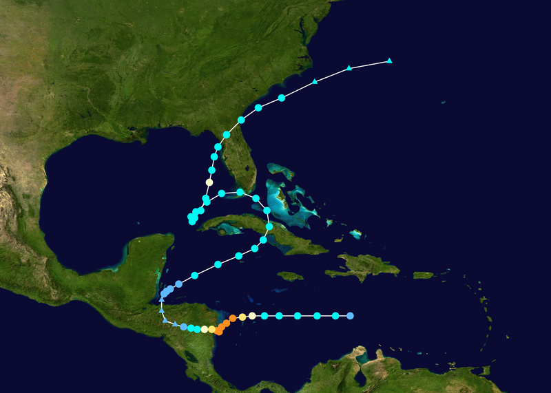
English: Track map of Hurricane Eta of the 2020 Atlantic hurricane season. The points show the location of the storm at 6-hour intervals. The colour represents the storm's maximum sustained wind speeds as classified in the (see below), and the shape of the data points represent the nature of the storm, according to the legend below. 열대저기압 (≤38 mph, ≤62 km/h)
열대폭풍 (39–73 mph, 63–118 km/h)
1등급 (74–95 mph, 119–153 km/h)
2등급 (96–110 mph, 154–177 km/h)
3등급 (111–129 mph, 178–208 km/h)
4등급 (130–156 mph, 209–251 km/h)
5등급 (≥157 mph, ≥252 km/h)
알 수 없음
|
||
| 날짜 | 2020-10-31–2020-11-14 | ||
| 출처 | Created by FleurDeOdile using Wikipedia:WikiProject Tropical cyclones/Tracks. The background image is from NASA. Tracking data is from the National Hurricane Center[1]. | ||
| 저자 | FleurDeOdile | ||
| Source code | Track map data table, if present below, is in HURDAT2 or ATCF format. See format details in [2] and [3], respectively.
|
라이선스
[편집]| 이 작품은 저작자인 FleurDeOdile에 의해 퍼블릭 도메인으로 공개된 작품입니다. 이 공개 선언은 전 세계적으로 유효합니다. 만약 저작권의 포기가 법률적으로 가능하지 않은 경우, FleurDeOdile은 이 작품을 법적으로 허용되는 한도 내에서 누구나 자유롭게 어떤 목적으로도 제한 없이 사용할 수 있도록 허용합니다. |
파일 역사
날짜/시간 링크를 클릭하면 해당 시간의 파일을 볼 수 있습니다.
| 날짜/시간 | 섬네일 | 크기 | 사용자 | 설명 | |
|---|---|---|---|---|---|
| 현재 | 2024년 1월 29일 (월) 22:35 | | 2,700 × 1,926 (3.43 MB) | Supportstorm (토론 | 기여) | Reverted to version as of 05:37, 10 June 2021 (UTC) Upload as separate file |
| 2024년 1월 29일 (월) 05:13 |  | 2,700 × 1,926 (4.32 MB) | 2003 LN6 (토론 | 기여) | recoloring | |
| 2021년 6월 10일 (목) 05:37 |  | 2,700 × 1,926 (3.43 MB) | Supportstorm (토론 | 기여) | TCR best track update | |
| 2020년 12월 11일 (금) 17:53 |  | 2,700 × 1,986 (2.91 MB) | Supportstorm (토론 | 기여) | Running best track update | |
| 2020년 11월 14일 (토) 09:49 |  | 2,700 × 2,148 (3.21 MB) | Supportstorm (토론 | 기여) | 11/14 00Z (Final operational update) | |
| 2020년 11월 13일 (금) 18:56 |  | 2,700 × 1,842 (2.42 MB) | FleurDeOdile (토론 | 기여) | 11/13 06Z (NHC final) | |
| 2020년 11월 13일 (금) 01:40 |  | 2,700 × 1,794 (2.32 MB) | FleurDeOdile (토론 | 기여) | 11/13 00Z | |
| 2020년 11월 12일 (목) 17:30 |  | 2,700 × 1,669 (1.89 MB) | FleurDeOdile (토론 | 기여) | 11/12 12Z | |
| 2020년 11월 12일 (목) 01:34 |  | 2,700 × 1,669 (1.92 MB) | FleurDeOdile (토론 | 기여) | 11/12 00Z | |
| 2020년 11월 11일 (수) 16:29 |  | 2,700 × 1,669 (1.97 MB) | FleurDeOdile (토론 | 기여) | 11/11 12Z |
이 파일을 덮어쓸 수 없습니다.
이 파일을 사용하는 문서
다음 문서 2개가 이 파일을 사용하고 있습니다:
이 파일을 사용하고 있는 모든 위키의 문서 목록
다음 위키에서 이 파일을 사용하고 있습니다:
- de.wikipedia.org에서 이 파일을 사용하고 있는 문서 목록
- en.wikipedia.org에서 이 파일을 사용하고 있는 문서 목록
- Template:Storm path
- Template:Storm path/doc
- List of Category 4 Atlantic hurricanes
- User:LightandDark2000/My Notable Storms
- Template:Storm path/sandbox
- User:Destroyeraa/Meteorological history of Hurricane Eta
- User:HurricaneTracker495/Effects of Hurricane Eta in Honduras
- User:Hurricaneboy23/2020 Tropical Cyclones
- User:TheWxResearcher/Tropical cyclones I've tracked
- es.wikipedia.org에서 이 파일을 사용하고 있는 문서 목록
- fi.wikipedia.org에서 이 파일을 사용하고 있는 문서 목록
- fr.wikipedia.org에서 이 파일을 사용하고 있는 문서 목록
- it.wikipedia.org에서 이 파일을 사용하고 있는 문서 목록
- kn.wikipedia.org에서 이 파일을 사용하고 있는 문서 목록
- ko.wikipedia.org에서 이 파일을 사용하고 있는 문서 목록
- nl.wikipedia.org에서 이 파일을 사용하고 있는 문서 목록
- pt.wikipedia.org에서 이 파일을 사용하고 있는 문서 목록
- shn.wikipedia.org에서 이 파일을 사용하고 있는 문서 목록
- simple.wikipedia.org에서 이 파일을 사용하고 있는 문서 목록
- te.wikipedia.org에서 이 파일을 사용하고 있는 문서 목록
- th.wikipedia.org에서 이 파일을 사용하고 있는 문서 목록
- tr.wikipedia.org에서 이 파일을 사용하고 있는 문서 목록
- tum.wikipedia.org에서 이 파일을 사용하고 있는 문서 목록
- vi.wikipedia.org에서 이 파일을 사용하고 있는 문서 목록
- www.wikidata.org에서 이 파일을 사용하고 있는 문서 목록
- zh.wikipedia.org에서 이 파일을 사용하고 있는 문서 목록
- zh.wikinews.org에서 이 파일을 사용하고 있는 문서 목록