File:Europe location SCO2.png
둘러보기로 이동
검색으로 이동

미리 보기 크기: 800 × 599 픽셀 다른 해상도: 320 × 240 픽셀 | 640 × 479 픽셀 | 1,024 × 767 픽셀 | 1,280 × 959 픽셀 | 1,594 × 1,194 픽셀
원본 파일 (1,594 × 1,194 픽셀, 파일 크기: 558 KB, MIME 종류: image/png)
캡션
설명
이 파일이 나타내는 바에 대한 한 줄 설명을 추가합니다
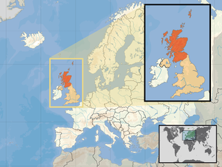
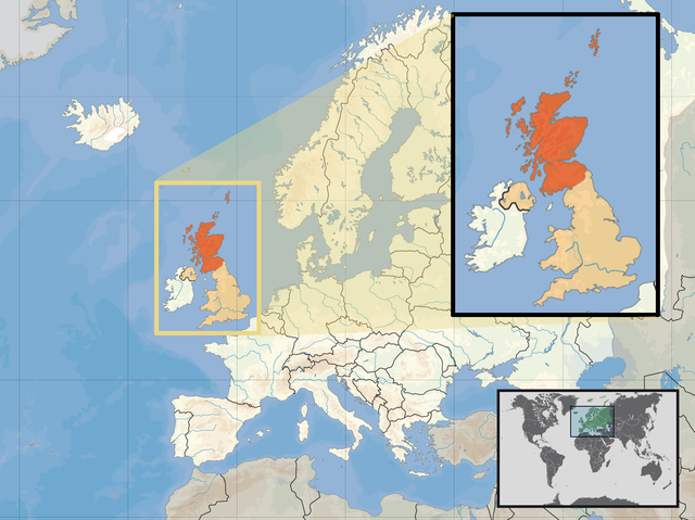
| 설명 | Location of Scotland in the UK and Europe, on terrain map showing surface and underwater contour areas. | |||
| 날짜 | ||||
| 출처 | Derived from Wikimedia Commons image of original work forming part of the "Europe location" map series created by David Liuzzo: derived from Image:Europe_location_SCO.png. | |||
| 저자 | uploaded by User:Kmusser (excerpt from User:David_Liuzzo) | |||
| 저작권 (이 파일을 인용하기) |
|
|||
| 다른 버전 |
|


파일 역사
날짜/시간 링크를 클릭하면 해당 시간의 파일을 볼 수 있습니다.
| 날짜/시간 | 섬네일 | 크기 | 사용자 | 설명 | |
|---|---|---|---|---|---|
| 현재 | 2017년 4월 10일 (월) 12:39 | | 1,594 × 1,194 (558 KB) | Von Sprat (토론 | 기여) | Reverted to version as of 12:25, 27 May 2010 (UTC) |
| 2017년 4월 10일 (월) 12:39 |  | 1,600 × 1,200 (788 KB) | Von Sprat (토론 | 기여) | greece/turkey border | |
| 2010년 5월 27일 (목) 12:25 |  | 1,594 × 1,194 (558 KB) | Ras67 (토론 | 기여) | cropped | |
| 2008년 9월 29일 (월) 17:31 |  | 1,600 × 1,200 (767 KB) | Kmusser (토론 | 기여) | re-cropped inset to include Shetlands | |
| 2008년 9월 29일 (월) 17:22 |  | 1,600 × 1,200 (807 KB) | Kmusser (토론 | 기여) | {{Information |Description= Location of Scotland in the UK and Europe, on terrain map showing surface and underwater contour areas. |Source=Derived from Wikimedia Commons image of original work forming part of the "Europe location" map series |
이 파일을 덮어쓸 수 없습니다.
이 파일을 사용하는 문서
이 파일을 사용하는 문서가 없습니다.
이 파일을 사용하고 있는 모든 위키의 문서 목록
다음 위키에서 이 파일을 사용하고 있습니다:
- als.wikipedia.org에서 이 파일을 사용하고 있는 문서 목록
- an.wikipedia.org에서 이 파일을 사용하고 있는 문서 목록
- az.wiktionary.org에서 이 파일을 사용하고 있는 문서 목록
- ca.wikipedia.org에서 이 파일을 사용하고 있는 문서 목록
- da.wikipedia.org에서 이 파일을 사용하고 있는 문서 목록
- en.wikipedia.org에서 이 파일을 사용하고 있는 문서 목록
- es.wikipedia.org에서 이 파일을 사용하고 있는 문서 목록
- eu.wiktionary.org에서 이 파일을 사용하고 있는 문서 목록
- ext.wikipedia.org에서 이 파일을 사용하고 있는 문서 목록
- fiu-vro.wikipedia.org에서 이 파일을 사용하고 있는 문서 목록
- fr.wikinews.org에서 이 파일을 사용하고 있는 문서 목록
- gag.wikipedia.org에서 이 파일을 사용하고 있는 문서 목록
- gl.wikipedia.org에서 이 파일을 사용하고 있는 문서 목록
- hr.wikipedia.org에서 이 파일을 사용하고 있는 문서 목록
- hr.wikiquote.org에서 이 파일을 사용하고 있는 문서 목록
- kn.wikipedia.org에서 이 파일을 사용하고 있는 문서 목록
- krc.wikipedia.org에서 이 파일을 사용하고 있는 문서 목록
- ml.wikipedia.org에서 이 파일을 사용하고 있는 문서 목록
- mnw.wikipedia.org에서 이 파일을 사용하고 있는 문서 목록
- mr.wikipedia.org에서 이 파일을 사용하고 있는 문서 목록
- my.wikipedia.org에서 이 파일을 사용하고 있는 문서 목록
- nov.wikipedia.org에서 이 파일을 사용하고 있는 문서 목록
- no.wikipedia.org에서 이 파일을 사용하고 있는 문서 목록
- pl.wikipedia.org에서 이 파일을 사용하고 있는 문서 목록
- pl.wikivoyage.org에서 이 파일을 사용하고 있는 문서 목록
- pl.wiktionary.org에서 이 파일을 사용하고 있는 문서 목록
- su.wikipedia.org에서 이 파일을 사용하고 있는 문서 목록
- sv.wikivoyage.org에서 이 파일을 사용하고 있는 문서 목록
- te.wikipedia.org에서 이 파일을 사용하고 있는 문서 목록
- tr.wikipedia.org에서 이 파일을 사용하고 있는 문서 목록
- ug.wikipedia.org에서 이 파일을 사용하고 있는 문서 목록
- vls.wikipedia.org에서 이 파일을 사용하고 있는 문서 목록
- yo.wikipedia.org에서 이 파일을 사용하고 있는 문서 목록