File:Eurozone map.svg
둘러보기로 이동
검색으로 이동

SVG 파일의 PNG 형식의 미리보기 크기: 454 × 450 픽셀. 다른 해상도: 242 × 240 픽셀 | 484 × 480 픽셀 | 775 × 768 픽셀 | 1,033 × 1,024 픽셀 | 2,066 × 2,048 픽셀
원본 파일 (SVG 파일, 실제 크기 454 × 450 픽셀, 파일 크기: 1.3 MB)
캡션
설명
이 파일이 나타내는 바에 대한 한 줄 설명을 추가합니다
파일 설명[편집]
| 설명 |
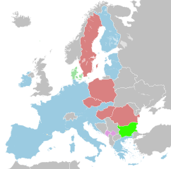
English:
English (en): A map of the Eurozone and the status of the surrounding countries and territories.
EU member states using the euro (Euro area) ERM II member states with an opt-out ERM II member states Other EU member states States using the euro as a result of a bilateral agreement with the EU States which have unilaterally adopted the euro
Magyar: magyar (hu): Európai unió és az eurózóna
Eurózóna ERM-2-es tag opt-out opcióval ERM-2-es tag Egyéb EU-s államok Európai Unión kívüli államok, amelyek megállapodás alapján használnak eurót Európai Unión kívüli államok, amelyek megállapodás nélkül használnak eurót
|
| 날짜 | |
| 출처 | 자작 |
| 저자 | Ssolbergj |
| SVG 발전 |
라이선스[편집]
| 나는 이 작품의 저작권자로서, 이 작품을 퍼블릭 도메인으로 모두에게 공개합니다. 이 공개 선언은 전 세계적으로 유효합니다. 만약 저작권의 포기가 법률적으로 가능하지 않은 경우, 나는 이 작품을 법적으로 허용되는 한도 내에서 누구나 자유롭게 어떤 목적으로도 제한없이 사용할 수 있도록 허용합니다. |
파일 역사
날짜/시간 링크를 클릭하면 해당 시간의 파일을 볼 수 있습니다.
| 날짜/시간 | 섬네일 | 크기 | 사용자 | 설명 | |
|---|---|---|---|---|---|
| 현재 | 2023년 9월 11일 (월) 02:52 | | 454 × 450 (1.3 MB) | Punkboy3401 (토론 | 기여) | Fixed code |
| 2023년 8월 31일 (목) 11:07 |  | 454 × 450 (1.3 MB) | Ahmetlii (토론 | 기여) | fix croatian border | |
| 2023년 8월 26일 (토) 21:30 |  | 454 × 450 (1.3 MB) | Punkboy3401 (토론 | 기여) | Correction of borders | |
| 2023년 1월 1일 (일) 14:48 |  | 454 × 450 (1.31 MB) | Iktsokh (토론 | 기여) | Correction of borders | |
| 2022년 12월 31일 (토) 20:42 |  | 454 × 450 (1.3 MB) | Edroeh (토론 | 기여) | Croatia introduced the Euro. | |
| 2022년 7월 13일 (수) 21:31 |  | 454 × 450 (1.3 MB) | EmmaCoop (토론 | 기여) | Cleaning up errors found on validator | |
| 2020년 1월 29일 (수) 21:20 |  | 454 × 450 (1.3 MB) | Edroeh (토론 | 기여) | Brexit update | |
| 2020년 1월 2일 (목) 03:39 |  | 454 × 450 (1.3 MB) | Edroeh (토론 | 기여) | Bulgaria and Croatia applied for ERMII | |
| 2019년 11월 16일 (토) 02:59 |  | 454 × 450 (1.3 MB) | Danlaycock (토론 | 기여) | rvt - colour to similar to ERM states to be usefull | |
| 2019년 11월 12일 (화) 16:08 |  | 454 × 450 (1.3 MB) | Edroeh (토론 | 기여) | Bulgaria/Croatia changed to ERM II membership applied |
이 파일을 덮어쓸 수 없습니다.
이 파일을 사용하는 문서
다음 문서 2개가 이 파일을 사용하고 있습니다:
이 파일을 사용하고 있는 모든 위키의 문서 목록
다음 위키에서 이 파일을 사용하고 있습니다:
- az.wikipedia.org에서 이 파일을 사용하고 있는 문서 목록
- be-tarask.wikipedia.org에서 이 파일을 사용하고 있는 문서 목록
- bg.wikipedia.org에서 이 파일을 사용하고 있는 문서 목록
- bn.wikipedia.org에서 이 파일을 사용하고 있는 문서 목록
- ca.wikipedia.org에서 이 파일을 사용하고 있는 문서 목록
- ckb.wikipedia.org에서 이 파일을 사용하고 있는 문서 목록
- en.wikipedia.org에서 이 파일을 사용하고 있는 문서 목록
- et.wikipedia.org에서 이 파일을 사용하고 있는 문서 목록
- fa.wikipedia.org에서 이 파일을 사용하고 있는 문서 목록
- fo.wikipedia.org에서 이 파일을 사용하고 있는 문서 목록
- hi.wikipedia.org에서 이 파일을 사용하고 있는 문서 목록
- hu.wikipedia.org에서 이 파일을 사용하고 있는 문서 목록
- hy.wikipedia.org에서 이 파일을 사용하고 있는 문서 목록
- id.wikipedia.org에서 이 파일을 사용하고 있는 문서 목록
- incubator.wikimedia.org에서 이 파일을 사용하고 있는 문서 목록
- io.wikipedia.org에서 이 파일을 사용하고 있는 문서 목록
- it.wikipedia.org에서 이 파일을 사용하고 있는 문서 목록
- ka.wikipedia.org에서 이 파일을 사용하고 있는 문서 목록
- ko.wikipedia.org에서 이 파일을 사용하고 있는 문서 목록
- lij.wikipedia.org에서 이 파일을 사용하고 있는 문서 목록
- li.wikipedia.org에서 이 파일을 사용하고 있는 문서 목록
- mi.wikipedia.org에서 이 파일을 사용하고 있는 문서 목록
- nl.wikipedia.org에서 이 파일을 사용하고 있는 문서 목록
- Euro
- Sjabloon:Zijbalk kaart eurozone
- Tijdlijn van de Europese staatsschuldencrisis (2010)
- Tijdlijn van de Europese staatsschuldencrisis (2011)
- Tijdlijn van de Europese staatsschuldencrisis (2012)
- Tijdlijn van de Europese staatsschuldencrisis (2013)
- Tijdlijn van de Europese staatsschuldencrisis (2014)
- os.wikipedia.org에서 이 파일을 사용하고 있는 문서 목록
이 파일의 더 많은 사용 내역을 봅니다.