File:Frederick Palmer, Plan of Jaffa (FL167448717 2370237).jpg
קפיצה לניווט
קפיצה לחיפוש
גודל התצוגה המקדימה הזאת: 528 × 600 פיקסלים. רזולוציות אחרות: 211 × 240 פיקסלים | 423 × 480 פיקסלים | 676 × 768 פיקסלים | 902 × 1,024 פיקסלים | 1,803 × 2,048 פיקסלים | 4,422 × 5,022 פיקסלים.
לקובץ המקורי (4,422 × 5,022 פיקסלים, גודל הקובץ: 16.53 מ"ב, סוג MIME: image/jpeg)
כיתובים
כיתובים
נא להוסיף משפט שמסביר מה הקובץ מייצג
תקציר
[עריכה]| פרדריק פלמר: Plan of Jaffa
( |
||||||||||||||||||||||||
|---|---|---|---|---|---|---|---|---|---|---|---|---|---|---|---|---|---|---|---|---|---|---|---|---|
| אומן |
|
|||||||||||||||||||||||
| כותרת |
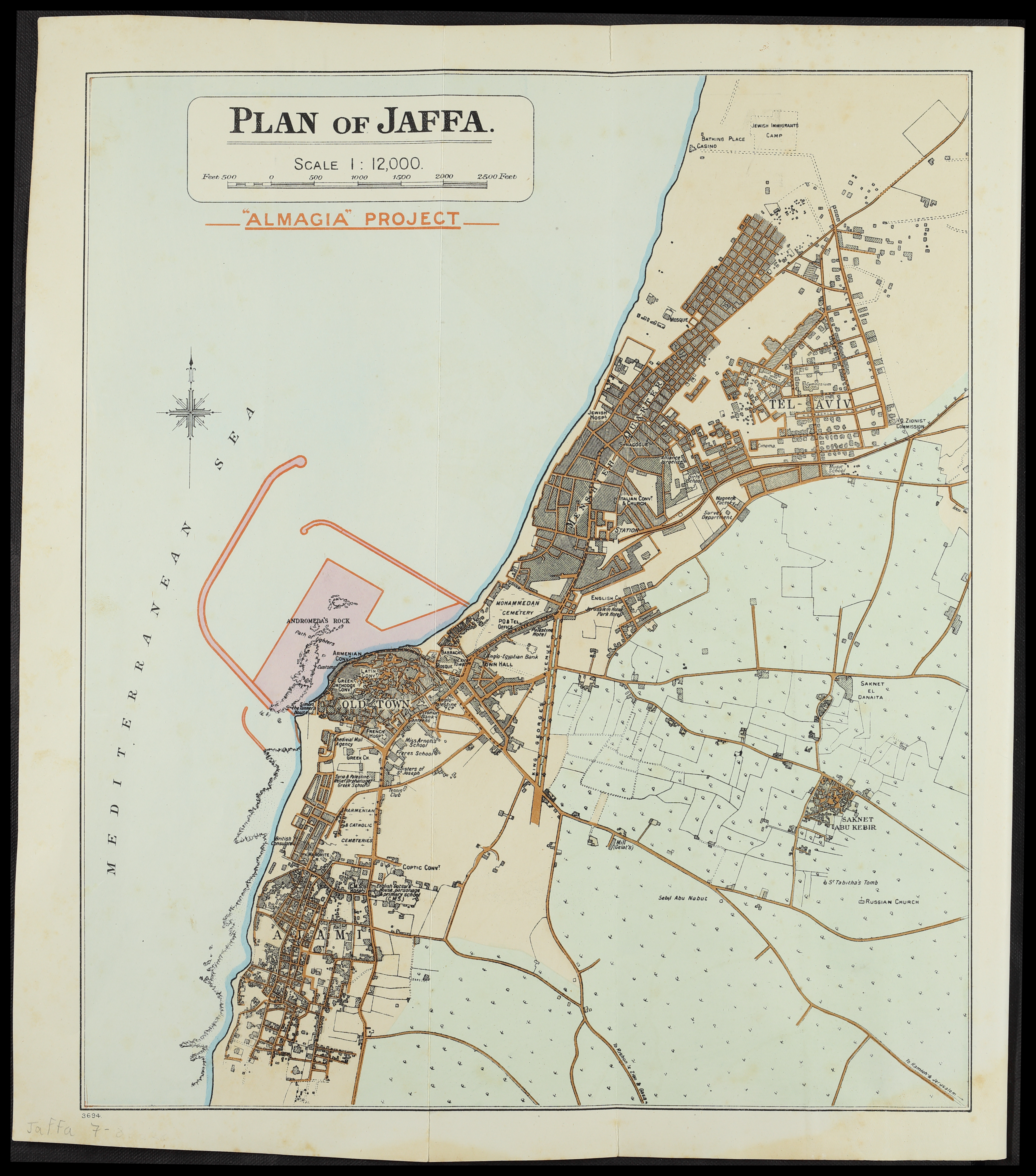
Plan of Jaffa |
|||||||||||||||||||||||
| מפרסם |
Eyre & Spottiswoode |
|||||||||||||||||||||||
| תיאור |
Plan of Jaffa. Almagia project.. |
|||||||||||||||||||||||
| שפה | אנגלית | |||||||||||||||||||||||
| תאריך הוצאה לאור | 1923 | |||||||||||||||||||||||
| אוסף |
|
|||||||||||||||||||||||
| מיקום נוכחי |
|
|||||||||||||||||||||||
| מיקום הוצאה | לונדון | |||||||||||||||||||||||
| חיפוש בקטלוג מרחב | לונדון | |||||||||||||||||||||||
| הערות | From: Palmer, F. Report on the provision of harbour facilities for Palestine, 1923. After p.14. | |||||||||||||||||||||||
| קנה מידה | 1:12,000 cm | |||||||||||||||||||||||
| IE PID | IE167448715 | |||||||||||||||||||||||
| רוזטה שם קובץ | FL167448717 | |||||||||||||||||||||||
| מזהה רשומה בספרייה הלאומית (P3959) | 990023702370205171 | |||||||||||||||||||||||
| חיפוש בקטלוג מרחב | אנגלית, פרדריק פלמר | |||||||||||||||||||||||
| חיפוש בקטלוג מרחב | Eyre & Spottiswoode | |||||||||||||||||||||||
| סימוכין | ||||||||||||||||||||||||
| מקור/צלם |
|
|||||||||||||||||||||||
| גרסאות אחרות | ||||||||||||||||||||||||
| Jpg / Tif version |
|
|||||||||||||||||||||||


.jpg)

.jpg&action=edit§ion=1)
רישיון
[עריכה].jpg&action=edit§ion=2)
The copyright situation of this work is theoretically uncertain, because in the country of origin copyright lasts 70 years after the death of the author, and the date of the author's death is unknown. However, the date of creation of the work was over 120 years ago, and it is thus a reasonable assumption that the copyright has expired (see here for the community discussion). Do not use this template if the date of death of the author is known.
| |
| הקובץ הזה זוהה כקובץ חופשי מכל מגבלה ידועה תחת חוק זכויות היוצרים, כולל כל הזכויות הקשורות והסמוכות. | |
היסטוריית הקובץ
ניתן ללחוץ על תאריך/שעה כדי לראות את הקובץ כפי שנראה באותו זמן.
| תאריך/שעה | תמונה ממוזערת | ממדים | משתמש | הערה | |
|---|---|---|---|---|---|
| נוכחית | 00:28, 26 ביולי 2023 | | 5,022 × 4,422 (16.53 מ"ב) | Geagea (שיחה | תרומות) | pattypan 22.03 |
אין באפשרותך לדרוס את הקובץ הזה.
שימוש בקובץ
הדף הבא משתמש בקובץ הזה:
.jpg&oldid=787630315)