File:Fukushima I NPP 1975 medium crop rotated labeled.jpg
קפיצה לניווט
קפיצה לחיפוש

גודל התצוגה המקדימה הזאת: 300 × 600 פיקסלים. רזולוציות אחרות: 120 × 240 פיקסלים | 240 × 480 פיקסלים.
לקובץ המקורי (800 × 1,600 פיקסלים, גודל הקובץ: 248 ק"ב, סוג MIME: image/jpeg)
כיתובים
כיתובים
נא להוסיף משפט שמסביר מה הקובץ מייצג
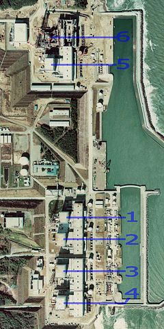
Aerial view of the plant area in 1975, showing separation between Units 5 & 6, and the majority of the complex
תקציר
[עריכה]
| תיאור |
English: Fukushima I Nuclear Power Plant. Medium crop showing reactors labeled 1 to 5 and site for reactor 6. North is up.
日本語: 福島第一原子力発電所。 |
| תאריך יצירה | |
| מקור | http://w3land.mlit.go.jp/cgi-bin/WebGIS2/WC_AirPhoto.cgi?IT=p&DT=n&PFN=CTO-75-30&PCN=C29B&IDX=21 |
| יוצר | Ministry of Land, Infrastructure, Transport and Tourism |
| גרסאות אחרות |
|
| מיקום המצלמה | | תמונה זו ותמונות נוספות במיקום: OpenStreetMap |
|---|
רישיון
[עריכה]

|
בעלי זכויות היוצרים על הקובץ הזה, משרד הקרקעות, התשתיות, התחבורה והתיירות (יפן), מאשרים לכולם להשתמש בו לכל מטרה, בתנאי שניתן לבעלי הזכויות ייחוס נאות. הפצה, יצירות נגזרות, שימושים מסחריים וכל שימוש אחר מותרים. |
ייחוס:
Copyright © National Land Image Information (Color Aerial Photographs), Ministry of Land, Infrastructure, Transport and Tourism
|
 |
This image is copyrighted by the Ministry of Land, Infrastructure, Transport and Tourism of Japan. For terms of use, see the stipulation to use of National Land Information (in Japanese) and message from MLIT (in Japanese and English). When you display this image on an article, include the following phrase in the description: "Made based on National Land Image Information (Color Aerial Photographs), Ministry of Land, Infrastructure, Transport and Tourism".
|
היסטוריית הקובץ
ניתן ללחוץ על תאריך/שעה כדי לראות את הקובץ כפי שנראה באותו זמן.
| תאריך/שעה | תמונה ממוזערת | ממדים | משתמש | הערה | |
|---|---|---|---|---|---|
| נוכחית | 23:54, 15 במרץ 2011 | | 1,600 × 800 (248 ק"ב) | 84user (שיחה | תרומות) | =={{int:filedesc}}== {{Information |Description={{en|1=Fukushima I Nuclear Power Plant. Medium crop showing reactors labeled 1 to 5 and site for reactor 6. North is up.}} {{ja|1=[[:ja:福島第一原子力発電所| |
אין באפשרותך לדרוס את הקובץ הזה.
שימוש בקובץ
הדפים הבאים משתמשים בקובץ הזה:
שימוש גלובלי בקובץ
אתרי הוויקי השונים הבאים משתמשים בקובץ זה:
- שימוש באתר ar.wikipedia.org
- שימוש באתר ast.wikipedia.org
- שימוש באתר be-tarask.wikipedia.org
- שימוש באתר ca.wikipedia.org
- שימוש באתר cs.wikipedia.org
- שימוש באתר cv.wikipedia.org
- שימוש באתר de.wikipedia.org
- שימוש באתר de.wikinews.org
- שימוש באתר en.wikipedia.org
- שימוש באתר en.wikibooks.org
- שימוש באתר es.wikipedia.org
- שימוש באתר fi.wikipedia.org
- שימוש באתר fr.wikipedia.org
- שימוש באתר gl.wikipedia.org
- שימוש באתר he.wikipedia.org
- שימוש באתר hi.wikipedia.org
- שימוש באתר ja.wikipedia.org
- שימוש באתר ko.wikipedia.org
- שימוש באתר ko.wikinews.org
- שימוש באתר ms.wikipedia.org
- שימוש באתר nl.wikipedia.org
- שימוש באתר pl.wikipedia.org
- שימוש באתר pt.wikipedia.org
- שימוש באתר rm.wikipedia.org
- שימוש באתר ru.wikipedia.org
- שימוש באתר sq.wikinews.org
- שימוש באתר ta.wikipedia.org
- שימוש באתר th.wikipedia.org
- שימוש באתר tr.wikipedia.org
- שימוש באתר zh.wikipedia.org