File:Gaza (FL32714071 3435742).jpg
קפיצה לניווט
קפיצה לחיפוש

גודל התצוגה המקדימה הזאת: 416 × 599 פיקסלים. רזולוציות אחרות: 167 × 240 פיקסלים | 333 × 480 פיקסלים | 533 × 768 פיקסלים | 711 × 1,024 פיקסלים | 1,422 × 2,048 פיקסלים | 2,953 × 4,252 פיקסלים.
לקובץ המקורי (2,953 × 4,252 פיקסלים, גודל הקובץ: 15.85 מ"ב, סוג MIME: image/jpeg)
כיתובים
כיתובים
נא להוסיף משפט שמסביר מה הקובץ מייצג
תקציר
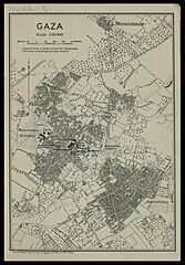
[עריכה]| Gaza
( |
||||||||||||||||||||||||
|---|---|---|---|---|---|---|---|---|---|---|---|---|---|---|---|---|---|---|---|---|---|---|---|---|
| כותרת |
Gaza |
|||||||||||||||||||||||
| מפרסם |
Survey of Egypt |
|||||||||||||||||||||||
| תיאור |
Gaza. Reproduced by the Survey of Egypt. |
|||||||||||||||||||||||
| שפה | אנגלית | |||||||||||||||||||||||
| תאריך הוצאה לאור | 1917 | |||||||||||||||||||||||
| טכניקה | 1 map : col ; | |||||||||||||||||||||||
| ממדים | גובה: 16 ס"מ; רוחב: 11 ס"מ | |||||||||||||||||||||||
| אוסף |
|
|||||||||||||||||||||||
| מיקום נוכחי |
|
|||||||||||||||||||||||
| מיקום הוצאה | קהיר | |||||||||||||||||||||||
| חיפוש בקטלוג מרחב | קהיר | |||||||||||||||||||||||
| הערות | In: Military handbook on Palestine. Cairo, 1917. 2010 B 9042. Between pp.32-33. | |||||||||||||||||||||||
| קנה מידה | 1:15,000 cm | |||||||||||||||||||||||
| IE PID | IE32714069 | |||||||||||||||||||||||
| רוזטה שם קובץ | FL32714071 | |||||||||||||||||||||||
| מזהה רשומה בספרייה הלאומית (P3959) | 990034357420205171 | |||||||||||||||||||||||
| חיפוש בקטלוג מרחב | אנגלית | |||||||||||||||||||||||
| חיפוש בקטלוג מרחב | Survey of Egypt | |||||||||||||||||||||||
| מקור/צלם |
|
|||||||||||||||||||||||
| גרסאות אחרות | ||||||||||||||||||||||||
| Jpg / Tif version |
|
|||||||||||||||||||||||

.jpg)

.jpg&action=edit§ion=1)
רישיון
[עריכה].jpg&action=edit§ion=2)
This work was published before January 1, 1918 and it is anonymous or pseudonymous due to unknown authorship. It is in the public domain in the United States as well as countries and areas where the copyright terms of anonymous or pseudonymous works are 106 years or fewer since publication.
|
היסטוריית הקובץ
ניתן ללחוץ על תאריך/שעה כדי לראות את הקובץ כפי שנראה באותו זמן.
| תאריך/שעה | תמונה ממוזערת | ממדים | משתמש | הערה | |
|---|---|---|---|---|---|
| נוכחית | 06:45, 10 באוגוסט 2023 | | 4,252 × 2,953 (15.85 מ"ב) | Geagea (שיחה | תרומות) | pattypan 22.03 |
אין באפשרותך לדרוס את הקובץ הזה.
שימוש בקובץ
הדפים הבאים משתמשים בקובץ הזה:
.jpg&oldid=791789074)